Quick wins for a faster PC:
Repair Windows errors before they cause bigger problemsFix Now →Scan for outdated or missing drivers - takes under a minuteDriver Scan →Yes—being outside a high-risk flood zone does not mean a home cannot flood, or that flood insurance is unnecessary. A FEMA flood map is an important starting point, not a guarantee about a particular parcel’s drainage, erosion, future conditions, insurability, or ability to rebuild. Before committing to a shoreline property, check the parcel and its history, get a property-specific insurance quote, and find out which rules apply to the work you may want to do.
What a flood zone can—and cannot—tell you
Use the effective FEMA/National Flood Insurance Program (NFIP) map for the actual address or parcel. FEMA flood zones describe mapped flood hazards; they do not capture every factor that may affect a home. Local drainage, erosion, changing conditions, the building’s elevation and construction, and access or egress still matter.


| Map designation | What it indicates |
|---|---|
| A-family zones | High-risk flood areas. |
| V and VE zones | Coastal high-risk areas with additional wave hazard. |
Record the zone, any base flood elevation shown, and the map panel and effective date. If the result is unclear, or you suspect a map amendment or revision affects the parcel, ask the local floodplain administrator to clarify. Check community flood history separately; a map classification is not a record of every event at the property.
FloodSmart says “Every home has some flood risk.” On its current “What Is My Flood Risk” page, the National Flood Insurance Program reports that 99% of U.S. counties experienced a flood event over the past 20 years. It also reports that 29% of NFIP flood claims from 2014–2024 came from outside current high-risk areas. These national figures provide context; they are not a forecast for an individual home. FloodSmart also reports an average payment of $82,614 for all claims between 2020–2024. That period-specific figure is not an estimate of what a claim at a particular property would pay.
For coastal parcels, NOAA’s Coastal Flood Exposure Mapper can add screening layers for hazards and exposure, including storm surge, high-tide flooding, and sea-level rise. NOAA cautions that the tool shows the scale of potential flooding rather than exact locations, does not account for every process, and should be checked against a site visit and local information. It says the tool is for planning reference, not navigation, permitting, or other legal purposes.
How to decide whether to buy flood insurance
Most standard homeowners policies exclude flood damage. Ask an insurer or agent for a quote tied to the specific property before your purchase becomes difficult to reverse. A lender’s mandatory-purchase condition generally applies to a federally backed mortgage on a property in a high-risk zone in an NFIP-participating community. That requirement is not a finding that a home outside such a zone cannot flood or does not need coverage.
Rank #2
NFIP homeowner coverage has separate building and contents categories. The program’s stated maximums are not a recommendation for how much protection a buyer needs:
| NFIP homeowner coverage category | Stated maximum | What to confirm |
|---|---|---|
| Building | Up to $250,000 | Whether the limit and replacement-cost treatment suit the structure. |
| Contents | Up to $100,000 | Whether the limit suits the belongings and the policy’s terms. |
These are separate coverage categories and typically have separate deductibles. Premiums depend on factors including location, construction, and replacement cost. Do not assume a uniform price from a map zone or a national average; request a written, property-specific quote.
Rank #3
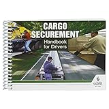
- Handbook helps cargo trailer drivers stay safe and in compliance with U.S. and Canadian load securement requirements.
- Load securement book combines cargo securement regulations with practical hands-on guidance and illustrated best practices in one convenient source.
- Helps drivers determine the best approach to securing cargo and cargo trailer accessories they're transporting, based on government recommendations.
- Provides need-to-know guidelines on proper use of blocks, ropes, chains, bars, and more for flatbeds, dry vans, reefers, and other widely used types of trailers. Also provides critical information about general load securement requirements, commodity-specific requirements, cargo securement regulations, tiedown quick reference, frequently asked questions, and much more.
- 7" x 5" English spiral bound handbook with 190+ pages. Copyright 2017.
Compare an NFIP option with any available private policy on the terms that affect your actual exposure:
- Total premium and renewal terms.
- Building and contents limits, deductibles, and exclusions.
- Waiting period and claims handling.
- Whether the policy covers the specific structure and intended use.
- Eligibility and how replacement cost is treated.
Ask the insurer to explain any limitations in writing. A low premium is not useful if the coverage, deductible, or exclusions do not match the property and your budget.
Rank #4
What to verify about the building and its history
Request available records from the seller and relevant local offices, and check how each record relates to the current building and parcel. Useful documents may include:
- Flood or water-damage history and available claim information.
- Elevation certificates or other prior elevation documentation.
- Flood-map change, amendment, or revision records.
- Permits and records for prior shoreline work or repairs.
- Surveys, easements, and recorded restrictions.
Compare documented building elevation and construction with relevant flood elevations and the insurance quote. A prior certificate or permit is evidence about a particular measurement or activity; it does not by itself establish current insurance terms or authorize future work. FEMA’s coastal construction guidance identifies siting, land-use restrictions, floodplain management, setbacks, and erosion as factors relevant to coastal building vulnerability.
Free tools Windows power users keep installed
One-click scans. No signup required.
Can you build a dock, seawall, or other shoreline improvement?
Do not assume an existing improvement can be repaired, replaced, or extended—or that an undeveloped shoreline can be altered. Requirements depend on the location and exact activity. Work in or over navigable waters may require federal review under Section 10. Discharging dredged or fill material into waters, including some wetlands, may require authorization under Section 404. A federal permit does not replace state or local approvals.
Before assigning value to a dock, seawall, bulkhead, beach nourishment, fill, grading, or similar proposal, ask which agencies have jurisdiction and what approvals apply to that exact work. Also check state coastal boundaries and setbacks, wetlands requirements, floodplain ordinances, zoning, building codes, easements, and recorded restrictions. A national screening map cannot answer whether a specific project is permitted.
State disclosures and the Florida example
Disclosure requirements differ by state and sometimes by locality. For a Florida property partially or entirely seaward of the coastal construction control line, 2026 Florida Statutes § 161.57 requires a written coastal-property disclosure no later than contract execution. The statute’s disclosure says: “The property being purchased may be subject to coastal erosion and to federal, state, or local regulations that govern coastal property, including the delineation of the coastal construction control line, rigid coastal protection structures, beach nourishment, and the protection of marine turtles.”
At closing, unless waived in writing, the seller must provide an affidavit or qualifying survey delineating the line’s location on the property. The statute also says that failure to provide the disclosure or survey does not itself invalidate the contract or create a purchaser’s right to rescind. This is a Florida-specific example, not a nationwide rule. Have transaction counsel and the relevant state or local office confirm what applies to the property you are considering.
Recommended Free Tools
A due-diligence sequence before your purchase is final
- Map the parcel. Search the exact address or parcel in the FEMA Flood Map Service Center. Save the zone, base flood elevation if shown, map panel, and effective date; ask the local floodplain administrator about unclear results or map changes.
- Add local and coastal context. Review community flood history and, for coastal property, use NOAA’s mapper as a screening aid. Follow up with a site visit and local information; do not treat the map output as a parcel-level legal or permitting decision.
- Get an insurance quote. Ask about NFIP and private-market availability, limits, premium, deductibles, exclusions, waiting period, replacement-cost treatment, eligibility, and renewal terms for the actual structure.
- Review the property file. Request available claims and damage history, elevation documents, surveys, map-change records, permits, and shoreline-work records. Verify their relevance with local authorities and transaction counsel.
- Check intended work before valuing it. Identify the federal, state, and local agencies for any proposed dock, shoreline protection, fill, repair, or other change. Confirm approvals and restrictions before relying on the improvement or assuming it can be rebuilt.
For parcel-specific answers, speak with the local floodplain administrator, state coastal management office, relevant permitting agencies, insurer, and qualified local surveyor, engineer, or construction professional. A nationwide overview cannot establish a specific parcel’s risk, premium, title or easement constraints, disclosure duties, or right to alter or rebuild.
Quick Recap
Product prices and availability are accurate as of the date/time indicated and are subject to change. Any price and availability information displayed on Amazon at the time of purchase will apply.