Free tools Windows power users keep installed
One-click scans. No signup required.
Some links on this page are affiliate links: if you buy through them we may earn a commission, at no extra cost to you.
Reality capture is moving beyond one-off 3D scans. The useful end state is an operational digital twin: a digital representation of a building, bridge, factory, road or other asset that stays connected to its physical counterpart, carries lifecycle information and supports decisions such as maintenance, design changes and emergency response.
That shift combines terrestrial and mobile LiDAR, photogrammetry, drones, sensors, artificial intelligence and interoperable data services. A scan supplies geometry; a trustworthy twin adds context, time, uncertainty, permissions and a route for updated information to flow back from the asset.
As an Amazon Associate I earn from qualifying purchases.
What is reality capture?
The Digital Twin Consortium describes reality capture as devices and processes that record the condition of a physical object or space and create a digital duplicate. A digital twin, in the National Institute of Standards and Technology (NIST) definition, is an electronic representation of a real-world or non-physical entity that can represent states and transitions and support monitoring, simulation and control.
That distinction matters on a construction project. A point cloud from a site visit is a dataset. It becomes part of a twin only when it is aligned to a known coordinate system, linked to drawings, specifications and asset records, governed over time and connected to a decision or operation. A model that cannot be updated, traced to its source or interpreted with its uncertainty is not automatically a dependable twin.
Popular on Amazon
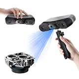
- 【Industrial-Grade Accuracy】Achieve single-frame accuracy up to 0.03 mm and volumetric accuracy of 0.03 mm + 0.05 mm x L(m), faithfully reproducing the finest surface details and complex geometries with exceptional consistency. Full-Field Structured Light accuracy reaches 0.08 mm; VCSEL mode delivers 0.10 mm @ 300-500 mm and 0.20 mm @ 500-800 mm. Engineered to meet the demanding requirements of 3D printing, reverse engineering, and precision modeling applications.
- 【Ultra-Fast Scanning & Robust Frame Rate】Multi-line Laser mode delivers up to 105 fps with NVIDIA GPU acceleration. Full-Field Structured Light mode achieves up to 5,000,000 points/s. The high frame rate ensures a smooth, uninterrupted scanning experience, especially suited for rapidly capturing large objects and complex scenes, significantly boosting overall workflow efficiency.
- 【AI-Powered & Photo-Grade Retopology】 AI object segmentation (Windows only) identifies your target in one click, tracks it throughout the scan, and auto-filters background noise — delivering clean data and streamlining post-processing. The patented 3D Gaussian Splatting converts point cloud and RGB data into true-to-life 1:1 photorealistic models; import photos from your phone or camera to apply real textures, then export in splat format for gaming, animation, and VR.
- 【All-Weather Outdoor Scanning】Multi-line Laser mode operates reliably up to 50,000 lux; with an outdoor filter attached, scanning remains stable in lighting conditions of up to 100,000 lux; VCSEL mode operates reliably in up to 100,000 lux ambient light. Designed to overcome lighting challenges, it provides consistent all-weather performance for construction sites, archaeological digs, and industrial fieldwork.
- 【5 Scanning Modes】NIR band supports Full-Field HD Scanning (markerless, fine structured light), Hybrid HD Scanning (dual projectors, fast high-quality modeling), and VCSEL Rapid Scanning (high-density pattern, fast markerless capture). Blue light band supports 30-Cross Laser Lines Scanning (handles high-reflectivity metals & dark objects) and Single-Line Deep Hole Scanning (captures from deep holes & narrow grooves). Five modes for comprehensive indoor and outdoor coverage.
Which capture method fits the job?
There is no single “best 3D scanner for a building.” Select the capture class according to required accuracy, coverage, speed, surface and lighting conditions, portability, registration effort, file size, software interoperability and how often the asset must be refreshed. LiDAR is a ranging method; a 3D scanner is the instrument that uses it, often alongside cameras.
| Capture class | Best-fit work | Typical performance or constraint | Trade-off |
|---|---|---|---|
| Tripod terrestrial scanner | Rooms, buildings, industrial assets, survey and high-consequence as-built checks | Typically survey-grade, below 5 mm according to the Digital Twin Consortium | Very accurate, but each setup, target and registration step takes time; dense files need capable processing and storage |
| Vehicle- or aircraft-mounted outdoor LiDAR | Roads, rail, utilities, terrain and other long linear or broad horizontal corridors | Typically within a few centimetres | Covers large areas quickly, while access, trajectory control and coordinate registration remain critical |
| Backpack or handheld indoor LiDAR | Fast interior mapping, renovation surveys and spaces where tripods are impractical | Trades some accuracy for portability and speed | Efficient coverage, but movement, occlusion and drift require careful control and review |
| Photogrammetry and sensor fusion | Visual documentation, drones, broad coverage, frequent updates and mixed camera, radar, IoT and LiDAR projects | Performance depends on image quality, overlap, lighting, texture and the sensors combined | Can add appearance and update frequency, but weak texture, glare, shadows and inconsistent sensor timing complicate processing |
“3D scanning versus LiDAR” is therefore a false either-or in many projects: LiDAR scanners and cameras can be fused, and photogrammetry can supply colour and visual context that a range-only survey does not.
How a scan becomes a digital twin
- Define the decision. State whether the deliverable is an as-built verification, clash investigation, maintenance baseline, inspection record, emergency scene or simulation input. This determines tolerances and the data that must be retained.
- Set control and permissions. Establish the coordinate reference, control points, site access, privacy rules, safety plan and retention policy before capture. Record equipment, calibration status, operator, date, weather and lighting where relevant.
- Capture with overlap and coverage. Plan scanner positions, trajectories or flight lines so that critical surfaces are seen from more than one angle. Add targets or surveyed control where registration and repeat surveys require it.
- Register and clean. Align stations or sensor streams, remove noise and classify points. Keep the raw observations and processing log; a smoothed or decimated cloud without lineage cannot support a defensible audit.
- Extract usable information. Convert geometry into walls, structural members, pipes, roads, defects, clearances or other assets. AI can accelerate registration, feature extraction and point-cloud processing, but specialists still need to check ambiguous surfaces, occlusions and outliers.
- Connect the model to operations. Attach drawings, specifications, serial numbers, inspection history, warranties, work orders and sensor feeds. Define which system is authoritative for each field and how changes are approved.
- Validate and refresh. Compare the twin with control measurements and known tolerances, quantify uncertainty and schedule recapture when construction progresses, assets move or condition changes. A two-way data path is what turns a static model into an operational twin.
Where the approach is already useful
Construction and the built environment
Teams can verify as-built conditions, coordinate trades, document progress and compare the site with design intent before installing work that would be expensive to remove. Repeat captures create an evidence trail, provided dates, coordinate systems and tolerances are retained.
Also popular on Amazon

- EASY TO USE FOR BEGINNERS – Perfect for entry-level users, DIY creators, and 3D printing enthusiasts. Quick start, with simple practice giving optimal scan results.
- SMOOTH WIRELESS SCANNING – WiFi6-powered Ferret Pro ensures fast, stable scanning. Works with Windows, macOS, Android, and iOS for flexible cross-platform use.
- HIGH-PRECISION 3D MODELS – Capture detailed 3D models with full-color 24-bit scanning and anti-shake technology. Offers up to 0.1mm accuracy with full-color scanning. Ideal for objects from 50mm to 2000mm. Not suitable for very small or highly detailed items like jewelry or precision parts.cccc
- VERSATILE OUTPUT & ENVIRONMENT – Export in OBJ, STL, or PLY. Works reliably in most settings, including outdoor light (<30,000 lux). Avoid reflective, transparent, or very dark surfaces for best results.
- LIGHTWEIGHT & PORTABLE – Weighing just 105g, carry and scan anywhere—home, studio, or on the go. Compact, convenient, and ready for travel.
Infrastructure
Road, rail, bridge, utility and public-asset owners can combine corridor mapping with inspection and condition data to prioritize intervention, renewal and future design. The UK Department for Transport describes an infrastructure digital twin as a virtual model linked to its real-world counterpart through a two-way flow of real-time data.
Manufacturing
Reality capture supports design, production, inspection and lifecycle management. A validated geometry baseline can feed predictive simulations, while sensor updates reveal how the physical process is diverging from the intended state.
Forensics and emergency response
NIST reports that investigators use terrestrial laser scanners and LiDAR to preserve spatial relationships. Its ForensiTwin project converts point clouds into an immersive virtual crime-scene twin for remote analysis, courtroom presentation and training, reducing the need to repeatedly access a scene.
Do these 3 things before closing this tab:
1Repair Windows errors before they cause bigger problems2Scan for outdated or missing drivers - takes under a minute3Clear out junk files and repair common Windows errorsAlso popular on Amazon
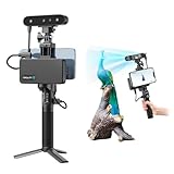
- 【High Accuracy & Fast Scanning】The Creality CR-Scan Ferret Pro 3D scanner delivers up to 0.1mm accuracy, 0.16mm resolution, and 30FPS scanning speed. It captures detailed dimensional data and complex shapes smoothly, creating highly realistic 3D models with ease.
- 【WiFi6 Wireless Transmission】Featuring advanced WiFi6, this handheld 3D scanner offers speeds 3x faster than WiFi5. The high bandwidth ensures stable, efficient data transfer for high-precision scanning and smoother workflow.
- 【Outdoor Scanning & Flexible File Export】Powered by upgraded optical technology and intelligent algorithms, the scanner delivers reliable performance in outdoor environments with ambient light up to 30,000 lux. Export models in OBJ, STL, or PLY formats for seamless integration with 3D printing, design, and reverse engineering workflows. For optimal results, avoid scanning highly reflective, transparent, or extremely dark surfaces.
- 【Anti-Shake Tracking】Equipped with one-shot 3D imaging, the Ferret Pro improves tracking accuracy and scanning success rates. Even with hand movements or quick object shifts, it ensures smooth, error-free scanning—perfect for beginners.
- Ferret Series Performance requirements: Windows: i5-Gen8 CPU or later Windows 10/11 (64-bit), RAM: >8GB, Software: >V2.3.0 Mac OS: M1/M2/M3/M4 series, macOS 11.7.7+ or Intel i5-Gen8+, RAM: >8GB Android: OS: Android 10.0+, RAM: >8GB, Connectivity: Wi-Fi 6, App: V2.0.2 iOS: Model: iPhone 11+, iOS 15+, RAM: >4GB
Media, heritage and immersive environments
Photogrammetry and LiDAR can produce navigable digital environments. Rights to imagery, provenance of the source data and long-term management of large files must be handled alongside the visual result.
Why AI does not make scanning automatic
AI is increasingly useful for registration, object and feature extraction, classification and conversion of point clouds into actionable models. It can reduce repetitive work and make frequent updates economically practical. It cannot, by itself, establish whether a hidden surface was missed, whether a coordinate transformation is correct or whether a model is safe to use for an engineering decision.
Human review remains necessary for uncertainty, occlusion, unusual geometry, sensor artefacts and changes that the training data did not represent. Keep confidence or uncertainty metadata with derived objects, not just a final rendered model.
Also popular on Amazon

- AI Visual Tracking Technology: Equipped with a new generation of single-frame encoded structured light units that improve surface feature detection for smooth, marker free scanning
- High Precision Scanning: Achieves 0.05mm accuracy using blue light technology, making your model size closely approach reality for detailed reproduction
- Fine Resolution Capability: Features 0.10mm resolution with detailed point clouds that preserve object details providing refined models for printing or display projects
- Versatile Scan Range: Capable of scanning objects ranging from 15mm to 1500mm, accommodating a wide variety of object sizes
- Integrated Software Solution: JMStudio scanning software integrates scanning, editing, and optimizing into one seamless process for efficient workflow
What still blocks adoption?
- Wrong equipment choice: a fast mobile system may not meet a survey tolerance, while a tripod workflow may be too slow for a moving project.
- Scale and access: large point clouds are expensive to process, view and share, and often require specialist hardware and software.
- Registration and documentation: poorly documented control, coordinate systems or processing steps make repeat surveys and audits unreliable.
- Time pressure: construction progress and emergency scenes can change before a complete capture is finished.
- Interpretation: extracting meaningful assets and defects still requires technical expertise.
- Interoperability: proprietary formats and disconnected systems can trap geometry away from BIM, geographic information, maintenance and sensor platforms.
- Workforce readiness: operators, surveyors, engineers, data stewards and security teams need shared procedures, not just new hardware.
NIST workshop findings published in 2026 add verification and validation, uncertainty quantification, cybersecurity and standards to the continuing research needs. These are governance requirements, not optional extras for a model that informs public safety or capital spending.
Windows Errors? Fix Them Before They Spread
Repair common Windows errors and clear accumulated junk for a smoother, more stable PC - no reinstall needed.Free scan · no reinstallOutdated Drivers Are Slowing You Down
One free scan finds every outdated or missing driver and matches the right update for your exact hardware.Free scan · exact hardware matchSecurity, standards and trust
NIST IR 8356 (2025) warns that digital twins introduce cybersecurity and trust concerns because they represent entities, states and transitions and may support monitoring or control. IEC’s 2025 industrial-metaverse report likewise identifies standardization gaps for industrial use cases.
During procurement, ask whether the platform provides open exchange formats, role-based access control, audit logs, versioning, uncertainty metadata, retention and deletion controls, and a clearly documented path for updates from the physical asset to the twin. Test an export and re-import with the systems that will actually use it instead of accepting an interoperability claim at face value.
Also popular on Amazon

- HIGH ACCURACY & FASTER: Boasting an impressive accuracy of up to 0.1mm, a resolution of 0.16mm, and a scanning speed of 30FPS, the Creality CR-Scan Ferret SE 3D scanner demonstrates outstanding performance in capturing extensive dimensional data and intricate details to shape highly realistic models smoothly and quickly
- ANTI-SHAKE TACKING: CR-Scan Ferret SE 3D scanner equipped with the new one-shot 3D imaging technology, this advanced feature enhances tracking efficiency and significantly increases the success rate of scans , ensures smooth, error-free scanning results even with shaky hands or rapid movements, ideal for beginners
- COLORFUL & VIVID TEXTURES: The CR Scan Ferret SE color 3D scanner built-in with the 2MP high-resolution color camera, captures intricate details and colored 3D models in their original colors, vividly bringing every intricate detail to life
- FLEXIBLE SCANNING RANGE: Provides a flexible scanning range of 150mm to 2000mm and a single capture range of up to 560*820mm, easily and efficiently handles the scanning of medium to large objects
- SCAN BLACK/METAL OBJECTS WITHOUT SPRAYING: The Ferret SE is optimized for scanning black or metal objects, it doesn't required you to use a white powder or spray to create a contrasting surface for black objects, much easier and faster to help you to finish your work
How to choose equipment and a workflow
Buy the class first and the model second. Choose a tripod terrestrial scanner when accuracy and traceability dominate; a handheld or backpack indoor LiDAR system when portability and rapid interior coverage matter; and vehicle- or drone-mounted LiDAR for large outdoor corridors. Budget for compatible tripods, targets, calibration tools, protective cases and high-capacity storage, then verify that each accessory works with the scanner and processing software.
Specify deliverables before requesting prices: raw data, registered point cloud, coordinate reference, classification, mesh or BIM output, tolerance report, metadata, retention period, update interval and responsibility for validation. Include software, cloud processing, workstation capacity, training and repeat-capture labour in the total workflow cost; the instrument price alone is not the project cost.
Quick wins for a faster PC:
Fix the driver behind crashes, sound loss and screen glitchesFind Drivers →Clear out junk files and repair common Windows errorsFree Scan →Scan for outdated or missing drivers - takes under a minuteDriver Scan →Are digital twins worth it?
They are most defensible where the cost of a wrong decision, a repeat site visit or an unplanned outage exceeds the cost of maintaining current, validated data. Deloitte reported on June 6, 2025 that a third-party estimate puts the global digital-twin market at nearly US$13 billion in 2023 and US$259 billion by 2032. That is a market forecast, not a measured total for reality-capture hardware or services.
For a construction owner, the practical test is smaller: can the team name the decision the twin improves, the data that must stay current, the person accountable for validation and the system that will consume the result? If those answers are clear, reality capture can progress from a one-time deliverable to a maintained operational asset.
Quick Recap
Product prices and availability are accurate as of the date/time indicated and are subject to change. Any price and availability information displayed on Amazon at the time of purchase will apply.

