What’s actually slowing this PC down?
Pick the symptom - the matching free tool is one click away.
Check the specific trail’s current status and the weather feeding its drainage before you leave. After rain, stay on marked paths, keep well back from waterfall edges, and never cross a stream that is swift, rising, muddy, or carrying debris. Storms upstream can send a surge into a canyon or gorge while the sky above you looks clear. If flooding is possible, a closure is posted, water is changing, or a crossing does not look plainly safe, postpone the hike, choose a different route, or turn around early.
This approach follows National Park Service guidance on river and stream safety, Great Smoky Mountains water safety, and Zion’s monsoon-season warnings. Footwear or a hiking stick may help on appropriate, stable sections, but no item makes a flooded channel, slick waterfall rock, or exposed edge safe.
As an Amazon Associate I earn from qualifying purchases.
Make the go, wait, or turn-back decision first
Waterfall trails are not automatically safe just because rain has stopped. Decide whether the route is appropriate before setting out, and be willing to change the plan at the trailhead or on the path. Treat the following as a decision gate rather than a score: one serious warning is enough to postpone or leave.
| Decision axis | What to check | Practical choice |
|---|---|---|
| Forecast and upstream weather | Local forecast, flash-flood potential, and weather in the drainage that feeds the trail | Postpone or select terrain outside flood-prone drainages when storms are possible |
| Current route status | Official trail alerts, hazard notices, and closures for the exact area | Obey a closure and use another open route |
| Route terrain | Canyons, gorges, washes, exposed stream banks, and required crossings | Avoid these features during storm conditions; do not cross swollen water |
| Water behavior | Rising or brown water, sticks or other debris, or a wash that has just begun flowing | Leave the drainage and reach high ground if flooding is developing |
| Waterfall proximity | How close the path and viewing area are to wet rock and an edge | Remain on the designated trail and view from a distance |
The National Park Service presents these hazards in separate park advisories; the table combines them into a practical choice for hikers. Conditions and closures can change quickly, so repeat the check before every outing.
#1 Best Overall

- OMNI-TECH: For prolonged exposure to moderate rain and snow. Multilayered, waterproof, seam-sealed construction that allows the inside to breathe, keeping feet dry and comfortable no matter the conditions.
- TECHLITE: For lightweight impact absorption on varied surfaces. Long-lasting cushioning with high energy return.
- OMNI-GRIP: For multi-terrain traction on rock, dirt, and gravel, in wet/dry conditions. Specially formulated compounds and tread design for cross-terrain stability and grip with strategically blended lug patterns.
- HANDY FEATURES: This adventure-ready hiker features a durable leather and mesh upper, metal hardware, and a cushioned collar for comfort.
- BUILT TO LAST: Columbia’s attention to detail is what sets our footwear apart. Specifying only the highest quality materials, expert stitching, and craftsmanship. This is long-lasting footwear you will enjoy for seasons to come.
Postpone when the route depends on a crossing
If a waterfall walk requires stepping through a stream, crossing a wash, or following a narrow bank, rain can remove your margin for error. A route that is normally easy may become impassable or dangerous before you arrive. Select a trail that stays on higher, stable ground instead of planning to “see how it looks” at the crossing.
Turn around before the hazard, not at it
Set a turnaround rule before you enter a canyon or drainage. If water rises, becomes opaque, starts carrying branches, or reaches a place where you cannot keep a stable footing, retreat along the route you know rather than moving farther toward the falls. Turning back is a successful safety decision, not a failed hike.
Check current information for the exact trail
General weather apps are not enough for a waterfall route. Look for the land manager’s current trail page, alerts, closure map, and flash-flood or severe-weather notices. Conditions at a park entrance may differ from conditions in the watershed above the falls.
- Identify the drainage. Note the creek, canyon, gorge, or wash the trail follows and the higher terrain that drains into it.
- Read the official forecast and hazard outlook. Check for thunderstorms, heavy rain, flash-flood potential, and storms expected upstream, not only at your starting point.
- Confirm the route is open. Search the official park or land-manager page for the trail name, recent closures, rockfall notices, washed-out crossings, and temporary viewing restrictions.
- Check again immediately before departure. A notice issued overnight or a storm that formed over the headwaters can change the decision after you made your plan.
- Tell someone the route and turnaround plan. Give a contact your trail, expected return, and the point at which you will turn back; update them if the route changes.
Zion National Park Superintendent Jeff Bradybaugh said in a National Park Service release published July 29, 2026: “For the health and safety of all visitors, Zion National Park provides numerous online tools and visitor center resources that can help visitors plan for a safe trip through the park.” Those tools are useful only when you consult the current information for your particular trail; a general park page cannot guarantee that a specific crossing or overlook is open.
Understand why upstream rain matters
Rainfall at the overlook is only one part of the hazard. Water from higher slopes can converge into a narrow drainage and arrive later, carrying more force than the local sky suggests. The Great Smoky Mountains National Park warns that localized rain on high peaks can produce sudden flooding lower down. Zion describes storms forming upstream and funneling water, rocks, debris, and tree limbs into drainages even when nearby skies are clear. Read the park warnings at Great Smoky Mountains water safety and Zion’s monsoon-season guidance.
Drainages amplify a small change
A broad trail can become a channel for runoff where the route enters a gorge, canyon, wash, or low bank. Water may rise rapidly, and the current can undermine edges or move rocks and branches. Do not assume that a familiar crossing is safe because it was shallow on a previous visit or because the rain fell miles away.
Do not wait for dramatic weather at your location
Blue sky, light local drizzle, or a dry parking area does not rule out a surge from the headwaters. If the forecast shows storms in the drainage, treat that information as a route hazard and choose higher, non-channel terrain or postpone.
Rank #2
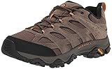
- Pigskin leather and mesh upper
- 100% recycled laces and webbing
- Bellows tongue keeps out debris
- Protective toe cap
- 100% recycled mesh lining
Recognize rising-water and flash-flood signs
Capitol Reef National Park identifies several visible warnings: muddy or brown water that is rising, sticks or debris moving in the flow, and formerly dry washes beginning to run. If you see any of these signs, stop moving toward the water.
- Rising level: Mark where the water is relative to a fixed bank feature; if it is climbing, leave the channel area immediately.
- Color change: Brown or opaque water can indicate sediment and a larger upstream flow.
- Floating material: Sticks, branches, rocks, or tree limbs show that the current is transporting debris.
- New flow: A dry wash or side channel that has begun running is a warning that more water may follow.
- Sound or force change: Louder, faster water and spray reaching areas that were dry on arrival mean conditions are changing.
During a flash flood, move to high ground and do not hike or drive through floodwater. Follow Capitol Reef’s flash-flood guidance for these warning signs and the instruction to leave the drainage.
A rainfall number is not a universal “safe” limit
Capitol Reef states that less than one half inch of rain within an hour can cause a flash flood. That figure is a warning specific to Capitol Reef’s terrain and watershed, and the page was last updated January 16, 2024; it is not a universal threshold for every waterfall trail. Watershed shape, soil, slope, channel size, and where the rain falls all change the outcome. Use local official forecasts and notices instead of applying one number to another park.
Keep away from waterfall edges and wet rock
Waterfall viewing areas combine a drop, moving water, and surfaces that become deceptively slick. Great Smoky Mountains hiking guidance says not to climb on rocks near waterfalls or walk near waterfall edges. Rocky Mountain National Park’s swift-water guidance likewise emphasizes that banks and rocks beside moving water can be slippery; see Great Smoky Mountains hiking safety and Rocky Mountain swift-water safety.
Quick wins for a faster PC:
Fix the driver behind crashes, sound loss and screen glitchesFind Drivers →Clear out junk files and repair common Windows errorsFree Scan →Scan for outdated or missing drivers - takes under a minuteDriver Scan →Use the trail as your safety boundary
- Stay behind railings, barriers, and signs, and keep both feet on the marked route.
- Do not climb above a waterfall for a photograph or step onto a lip, ledge, or wet boulder.
- Keep children and dogs close enough that they cannot reach the edge before you can intervene.
- View the falls from a stable, designated area rather than searching for a closer angle.
- Leave if crowding, slippery footing, or poor visibility prevents you from maintaining a safe position.
Extra traction can reduce slips on ordinary trail surfaces, but it does not make smooth, algae-covered, or water-sheened rock reliable. The hazard is the combination of footing, current, and a fall; equipment cannot remove those consequences.
Handle stream crossings conservatively
The safest crossing after heavy rain is often no crossing. Great Smoky Mountains guidance says to turn back, wait for conditions to improve, or use another route rather than crossing a rain-swollen or swift stream. Its water-safety video notes that a hiking stick can help prevent slips on appropriate crossings, but the same advice says not to cross swift streams after heavy rain. Read the guidance at the Great Smoky Mountains water-safety video and the park’s water-safety page.
Stop and assess from the bank
Do not enter the water to test its depth or current. Look for a designated bridge or an official alternate route. If no safe, marked option exists, return the way you came or postpone. A stick is a balance aid on stable ground, not permission to enter dangerous flow.
Rank #3

- TOWN OR TRAIL: Experience heel-to-toe comfort wherever you roam, and keep your style streamlined in this versatile low cut men’s shoe
- NIMBLE PERFORMANCE: A great all-around performer, made with a mesh upper, suede heel cap, and a wrap-around front tread that delivers nimble and durable performance
- FLEXIBLE WEBBING EYELETS: Integrated webbing eyelets provide a flexible lacing structure that adapts with your feet while providing a secure fit
- ALL-DAY SUPPORT: Our TechLite lightweight midsole provides lasting comfort, superior cushioning and high energy return for all-day comfort
- ALL TERRAIN TRACTION: Our Omni-Grip non-marking traction rubber outsole is indoor safe while providing high grip across a wide variety of wet and dry terrain
Why apparently shallow water can still be unsafe
Fast current can push a foot off balance, and submerged rocks may be uneven or loose. Muddy water hides the bottom and floating debris can strike a person. Banks may be undercut or slippery, so stepping close to the edge to “find a better spot” can create a second hazard.
What to do when conditions change on the hike
- Stop moving toward the water. Tell your group to pause together; do not split up to scout farther downstream.
- Identify the nearest high ground. Leave the wash, canyon floor, stream bank, or other low drainage using the safest marked route available.
- Watch for debris and rising flow. Give the channel a wide berth; never stand on a bridge or bank to watch a surge pass.
- Do not cross floodwater on foot or in a vehicle. Turn around and wait in a safe, elevated location or follow official evacuation instructions.
- Contact park staff or emergency services when appropriate. Use the location information you recorded before the hike and describe the trail, drainage, and visible hazard.
If a route is closed, do not bypass a barrier or take an unofficial social path. A detour can put you on unstable slopes or directly above the moving water the closure is intended to protect you from.
Choose safer alternatives after rain
You can still make a worthwhile outing without entering a flood-prone drainage. Choose a route that remains on a broad, established surface away from channels and waterfall rims, or visit a designated viewpoint that can be reached without a crossing. A shorter walk on higher ground is a better alternative than a longer route that depends on changing water.
Use a “route swap” instead of a forced decision
- Replace a canyon or gorge walk with an upland loop that has no stream crossing.
- Choose a maintained overlook set back from the falls rather than a path that approaches the brink.
- Visit a visitor center or official viewing area for current conditions and a recommended open trail.
- Reschedule the waterfall route for a period with a stable forecast and confirmed access.
Do not treat an alternative as safe merely because it is shorter. Apply the same checks for drainage, closures, wet rock, and upstream weather.
Independent reader supportYour contribution helps us test, update, and keep practical guides available for everyone.Use gear as support, not as a justification
Footwear
Great Smoky Mountains hiking guidance recommends suitable hiking shoes or boots. Select footwear with tread appropriate to the maintained trail, keep laces secure, and replace footwear that has lost its grip. No shoe is slip-proof on wet waterfall rock, and footwear does not reduce the force of moving water.
Recommended Free Tools
Hiking stick or trekking pole
A stick can provide an additional point of balance on an appropriate, stable section and is mentioned as a slip aid in the Great Smoky Mountains water-safety video. Keep the limitation in view: a pole cannot make a swift stream, unstable bank, or slick ledge safe to cross.
Planning items
Carry a charged phone, a map that works where reception is limited, water, weather-appropriate layers, and a light source if the return may extend. These items help you manage an ordinary hike and communicate a change of plan; they are not substitutes for obeying closures or turning back.
Rank #4

- OMNI-TECH: For prolonged exposure to moderate rain and snow. Multilayered, waterproof, seam-sealed construction that allows the inside to breathe, keeping feet dry and comfortable no matter the conditions.
- TECHLITE: For lightweight impact absorption on varied surfaces. Long-lasting cushioning with high energy return.
- OMNI-GRIP: For multi-terrain traction on rock, dirt, and gravel, in wet/dry conditions. Specially formulated compounds and tread design for cross-terrain stability and grip with strategically blended lug patterns.
- HANDY FEATURES: This adventure-ready hiker features a durable suede and mesh upper, metal hardware, and a cushioned collar for comfort.
- BUILT TO LAST: Columbia’s attention to detail is what sets our footwear apart. Specifying only the highest quality materials, expert stitching, and craftsmanship. This is long-lasting footwear you will enjoy for seasons to come.
A practical pre-hike and on-trail checklist
Before leaving
- Read the exact trail’s current status and hazard notices.
- Check local weather, flash-flood potential, and conditions upstream in the feeding drainage.
- Identify every canyon, wash, stream bank, and required crossing on the route.
- Choose a turnaround point and a high-ground option before starting.
- Tell someone your route, expected return, and any alternate plan.
- Wear suitable hiking footwear and carry basic navigation, communication, water, and lighting equipment.
At the trailhead
- Recheck posted closures, barriers, ranger instructions, and recent conditions.
- Look at the water from a safe distance; do not approach the edge to inspect it.
- Cancel or swap routes if rain is falling in the drainage or storms are building upstream.
On the trail
- Stay on marked paths and behind designated barriers.
- Keep away from waterfall edges, wet ledges, and rocks beside moving water.
- Stop at every crossing and use a bridge or official alternate when available.
- Turn back at the first sign of rising, muddy, debris-filled, or newly flowing water.
- Move to high ground if flooding begins; never hike or drive through floodwater.
Common mistakes that turn a wet hike into an emergency
“The rain stopped, so the danger is over”
Upstream runoff can arrive after local rain ends. Check the whole drainage and leave if water behavior changes.
“It is shallow enough to cross”
Depth is only one factor. Current, hidden rocks, debris, and an unstable bank can make shallow-looking water unsafe. Use the no-crossing decision for rain-swollen or swift flow.
Windows Errors? Fix Them Before They Spread
Repair common Windows errors and clear accumulated junk for a smoother, more stable PC - no reinstall needed.Free scan · no reinstallCrashes, No Sound, or Screen Glitches?
Random freezes, missing sound and display glitches usually trace back to one bad driver. Find and replace yours safely.Free scan · under a minute“I can get closer for one photograph”
Wet edges and rocks are fall hazards. Stay on the marked route and use the designated viewing distance.
“My gear will solve the problem”
Tread and a hiking stick may help on ordinary footing, but neither changes flood conditions or protects against a fall into moving water.
“The park is open, so every trail feature is open”
Park-wide access does not guarantee that a particular trail, crossing, overlook, or drainage is safe. Check the exact route and obey local barriers and notices.
The safest rule to remember
After rain, choose the route with the fewest water-related decisions. Confirm current conditions, account for weather upstream, stay on marked ground away from waterfall edges, and refuse any swollen or swift crossing. When water is rising, muddy, debris-filled, or newly flowing, leave the drainage for high ground. Waiting, changing trails, or turning around preserves the next opportunity to see the falls under safer conditions.
Free tools Windows power users keep installed
One-click scans. No signup required.
Quick Recap
Product prices and availability are accurate as of the date/time indicated and are subject to change. Any price and availability information displayed on Amazon at the time of purchase will apply.

