Free tools Windows power users keep installed
One-click scans. No signup required.
Urban soil has no universal “good” score. A parcel is performing well only when its soil can safely and reliably support the use you planned—such as food production, landscape vegetation, habitat, infiltration, or another construction-related function. Start by defining that use, then investigate site history, map distinct soil zones, inspect physical conditions, and order laboratory tests that answer the risks and performance questions for those zones.
This U.S.-focused workflow follows USDA Natural Resources Conservation Service (NRCS) and U.S. Environmental Protection Agency (EPA) guidance. Local regulations, cleanup standards, laboratory methods, and acceptable uses vary by state and municipality, so a site decision requires local interpretation rather than a generic pass/fail label.
As an Amazon Associate I earn from qualifying purchases.
Urban soil performance is a use-specific decision
USDA NRCS Technical Note 470-03 (January 2024) describes urban soils as having “great potential for agriculture and ecosystem services; however, soil health in urban sites is highly variable, ranging from robust conditions to highly degraded.” That range can occur within one city block. Construction fill, buried debris, former industrial activity, demolition, traffic, landscaping, and years of compaction can create sharply different conditions across a single parcel.
For that reason, evaluate performance against the job the soil must do:
#1 Best Overall

- Quick, at home results for Soil pH, Nitrogen, Phosphorous and Potash Innovative and inexpensive soil test kit features an easy-to-use capsule system and patented color comparators
- Contains all components needed for 20 tests. 5 for each of pH, N, P and K
- Contains all components needed to test all variables in several spots in the yard or garden
- Simple, detailed instructions included. Great for beginners and experienced gardeners alike.
- Soil pH preference list for over 450 plants included
- Food garden or edible landscaping: plants need suitable structure, water and air movement, nutrients, pH, organic matter, and a contaminant assessment appropriate to human exposure.
- Ornamental or native planting: rooting depth, drainage, compaction, salinity or other chemical constraints, and long-term maintenance may matter more than crop fertility.
- Habitat or ecosystem planting: biological condition, vegetation establishment, hydrology, and the ability to maintain desired species are central.
- Rain garden, bioswale, or other green infrastructure: infiltration rate, subsurface drainage, slope, runoff pathways, and compaction determine whether the installation stores and moves water as designed.
- Redevelopment or construction-adjacent land: exposure pathways, buried materials, grading, load-related compaction, and the proposed final surface must be evaluated together.
A soil that is excellent for a native planting may be unsuitable for vegetables. Soil that supports turf may still be too compacted for infiltration. A routine fertility report cannot establish that a former industrial surface is free of lead or other contaminants.
1. Define the planned use and assessment boundaries
Write down the intended use before collecting samples. Include who may contact the soil, whether anything will be eaten, whether stormwater will enter the area, and what construction or maintenance will occur. A community garden, residential side yard, public park, rain garden, and redevelopment parcel create different exposure and performance questions.
Create management units
Divide the property into areas that are likely to share a history and condition: an old driveway, a former building footprint, a fill pad, a lawn, a drainage low point, a demolished structure area, and an undisturbed edge should not automatically be combined. Record boundaries on a sketch or geographic map and keep every sample and recommendation tied to its unit.
Set the decision you need the assessment to support
- Can this zone support the planned planting or crop?
- Does it infiltrate enough water for the proposed green-infrastructure design?
- Should soil be amended, capped, removed, or replaced?
- Are there exposure concerns that require professional or regulatory review?
These are different decisions. Stating the decision first prevents buying a broad test package that does not answer the site’s actual risk.
2. Reconstruct site history before digging
NRCS Technical Note 470-03 recommends reviewing parcel boundaries, the Web Soil Survey, SSURGO data, other available maps, and the site’s use history. Search property records, historic maps, aerial imagery, permits, and interviews with owners or neighbors where available. A former factory, auto-related business, commercial yard, painted older residence, demolition site, or imported fill can suggest different contaminant and physical-condition concerns.
NRCS cautions that urban soil information is incomplete in many locations. Mapping is a starting point, not proof that the soil at a particular address matches a mapped unit. Grading, utility work, imported fill, and small-scale dumping can change soil conditions over short distances. The USDA NRCS Urban Soil Survey explains the uses and limits of urban mapping.
History changes the sampling question
If a zone has no known history, you still need a representative screening plan; “unknown” does not mean “clean.” If a zone has a plausible source of contamination, use that history to select laboratory analytes and locations with help from a qualified laboratory, Extension professional, environmental consultant, or public agency. Do not infer safety from vegetation appearance or from a single clean-looking surface.
PC Slower Than It Used to Be?
A free scan shows the junk files, broken settings and background clutter dragging Windows down - then fixes them in one click.Free scan · Windows 10 & 11Crashes, No Sound, or Screen Glitches?
Random freezes, missing sound and display glitches usually trace back to one bad driver. Find and replace yours safely.Free scan · under a minute3. Inspect physical and biological conditions in the field
Walk every management unit in wet and dry conditions when possible. NRCS includes physical and biological field assessment as part of urban soil evaluation. Use repeatable observations so one attractive corner does not stand in for the parcel.
Rank #2

- KNOW BEFORE YOU GROW | Grow the healthiest, sustainable lawn and garden with the most accurate and easy to use professional soil test kit on the market
- FAST & ACCURATE | Unlike at-home pH meters and test strips, our mail-in professional lab analysis accurately measures 13 plant-available nutrient levels, including Nitrogen and pH. Results in 6-8 days
- FOR ANY GROWING SCENARIO | Tests any soil type and growing condition - lawn & turf, vegetable gardening, flowers, compost, trees, vines, ornamental landscape, house plants, soil-less media or hydroponics
- SAVE TIME & MONEY | Stop applying products you don’t need. Learn exactly what products and amounts you need to grow the healthiest plants possible
- CUSTOM RECOMMENDATIONS | What to apply, how much to apply, and when to apply it. Provides both organic and non-organic fertilizer recommendations to effectively amend your soil
Record structure, hardness, and compaction
- Note whether soil breaks into stable aggregates or appears massive and sealed.
- Probe several points for a hard layer, shallow rooting, or abrupt changes between imported and native material.
- Look for wheel tracks, construction traffic, crusting, ponding, and roots confined to a thin surface layer.
- Compare high-traffic areas with vegetated or apparently undisturbed areas.
Compaction reduces pore space and can restrict roots, air exchange, and water movement. NRCS Technical Note 470-02 links compaction with reduced infiltration and increased runoff. Visual and tactile observations can reveal patterns, but they do not replace measurements where design or risk decisions depend on them.
Observe water, erosion, and surface cover
Map slopes, low points, roof and pavement runoff routes, standing water, rills, exposed subsoil, mulch, pavement, and bare ground. For a rain garden or other infiltration feature, the receiving area and the path water takes toward it are as important as the soil directly beneath the proposed footprint.
Consider biological indicators without overreading them
Vegetation density, root distribution, earthworm activity, residue, and organic matter clues can help describe soil function. Vigorous weeds do not prove that soil is suitable for crops, and sparse vegetation can reflect shade, mowing, drought, or compaction rather than contamination. Treat biological observations as evidence about condition, not as a contaminant screen.
4. Match tests to the intended function
Testing should answer a defined question and reflect the site’s history, local guidance, and laboratory method. EPA’s Evaluation of Urban Soils: Suitability for Green Infrastructure or Urban Agriculture separates growing-medium needs from potential contamination. Routine fertilizer testing alone is not clearance for contaminants.
Food-growing sites
For urban agriculture, NRCS identifies laboratory analysis of contaminants and a laboratory nutrient test, with soil-health indicators considered as appropriate. Ask the laboratory or an Extension service which analytes, sample depths, digestion or screening methods, quality controls, and interpretation fit the site’s history and the crops’ exposure pathways. The University of Connecticut Extension guidance on lead in garden soils (July 2026) distinguishes screening from confirmatory analysis and discusses test selection.
Include pH, nutrients, organic matter, and physical measurements when they will guide planting or amendment decisions. Add contaminant testing when history, fill, nearby sources, or intended exposure warrants it. A result from one bed cannot be generalized to another management unit.
Stormwater and green-infrastructure sites
EPA’s Urban Soils, Ecosystem Services, and the Application of Green Infrastructure Practices emphasizes infiltration and subsurface drainage. Assess infiltration at representative locations and depths, while documenting slope, groundwater or restrictive layers, nearby foundations, utilities, and the contributing drainage area. Compacted construction soil may shed water even when its surface looks dry. A design based on one convenient test pit can fail if the basin crosses contrasting fill or a shallow dense layer.
Recommended Free Tools
Planting, habitat, and general landscape areas
Prioritize rooting depth, structure, compaction, drainage, pH, salinity or other locally relevant chemical constraints, organic matter, and the tolerance of the proposed species. Native plants are not universally tolerant of saturated or compacted soil. If imported soil or unusual debris is present, include a contaminant question rather than assuming a non-food planting eliminates exposure concerns.
Rank #3
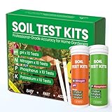
- Complete 4-in-1 Soil Test Kit (pH, N, P, K) – This garden soil test kit measures soil pH, Nitrogen, Phosphorus, and Potassium, giving you a full picture of your soil condition to improve fertilization and plant growth.
- 40 Accurate Tests for Long-Term Use – Includes 10 tests for each element (40 total tests), making this soil testing kit ideal for repeated use across multiple areas of your lawn, vegetable garden, or flower beds.
- Fast & Easy Soil Testing at Home – No calibration or complex tools needed. Simply mix soil with water, add the reagent, and compare the color chart for instant results. Perfect for beginners and experienced gardeners.
- All Tools Included for Convenience – This soil testing kit comes with test tubes, reagents, droppers, and a color comparison chart. Everything you need is included to perform reliable soil tests right at home.
- Improve Plant Growth & Save Fertilizer – By using this soil test kit for lawns and gardens, you can accurately balance soil nutrients, reduce waste, and grow healthier vegetables, flowers, and grass.
Redevelopment and construction-adjacent areas
Coordinate soil assessment with the project’s environmental and geotechnical requirements. A physical test may inform grading, drainage, or planting; it does not establish regulatory closure, worker safety, or suitability for unrestricted reuse. If contamination is suspected or results are elevated, the EPA report directs users toward Brownfields or state cleanup programs for assessment and remediation.
5. Keep physical condition separate from contamination
Two assessment tracks are necessary:
| Assessment track | Questions it answers | Typical evidence |
|---|---|---|
| Physical and biological performance | Can roots, air, and water move through the soil? Can the planned vegetation establish? Will stormwater infiltrate and drain? | Structure, hardness, compaction, infiltration, drainage, rooting depth, erosion, organic matter, and biological observations |
| Chemical and exposure condition | Are contaminants or chemical constraints present at levels relevant to the proposed use and exposure pathways? | History-informed laboratory contaminant analysis, pH, nutrients, and other locally relevant measurements interpreted by a qualified professional |
Improving structure with compost, ripping, replacement soil, or vegetation may improve infiltration and growth while leaving a contaminant problem unchanged. Conversely, a contaminant result does not tell you whether the soil is compacted or hydraulically suitable. Keep reports, maps, and recommendations for both tracks linked to the same management unit.
6. Build a representative sampling plan
Sampling quality often matters more than the size of the test package. Before collection, mark each management unit, choose sample locations that represent its variability, and document depth, date, weather, surface cover, and any unusual material. Avoid mixing visibly different soils into one composite unless the laboratory or sampling plan specifically calls for it.
Quick wins for a faster PC:
Repair Windows errors before they cause bigger problemsFix Now →Fix the driver behind crashes, sound loss and screen glitchesFind Drivers →Clear out junk files and repair common Windows errorsFree Scan →- Map distinct zones. Separate former structures, fill, pavement edges, gardens, low areas, slopes, and areas with different vegetation or disturbance.
- Choose locations within each zone. Include ordinary conditions and visible suspect areas; record coordinates or measured distances so the result can be relocated.
- Use the correct depth. Surface exposure, crop rooting depth, and deeper drainage questions may require different intervals. Follow the laboratory’s instructions rather than selecting a single depth for every purpose.
- Prevent cross-contamination. Use clean tools and containers, change gloves or clean equipment between zones, and follow laboratory handling and shipping requirements.
- Request interpretation with the method. Ask how the laboratory reports detection limits, screening results, confirmatory results, and comparison criteria for the intended use.
For homeowners asking which numbers deserve attention, Penn State Extension’s Gardening From the Ground Up frames interpretation as a question of what the result means for the particular yard. That is the right approach: a number without its method, sampled zone, intended use, and applicable local criterion is not a complete decision.
7. Use a penetrometer correctly
A soil penetrometer can help identify relative resistance and compacted layers. NRCS Technical Note 470-02 lists it as a specialized field assessment tool alongside visual and tactile assessment. Use repeated readings at comparable moisture conditions and depths, and record where each reading was taken.
A penetrometer does not identify lead or other contaminants, measure nutrient sufficiency, establish biological health, or certify that a site is suitable for a crop, park, or stormwater installation. Moisture, stones, roots, and operator technique affect readings. Treat it as one piece of a physical assessment, not as a safety test.
Independent reader supportYour contribution helps us test, update, and keep practical guides available for everyone.8. Interpret results for a management decision
Do not assign a generic “pass” or “fail.” Instead, compare findings with the planned use and the criteria that apply in your state or municipality.
If physical condition is limiting
Possible responses include reducing traffic, changing grading, adding site-appropriate organic amendments, establishing cover, improving surface drainage, replacing a planting medium, or using raised beds. The remedy depends on the depth and cause of the restriction; aggressive tillage can damage structure or utilities and may not solve a deep compacted layer. Base the action on test findings and local technical advice.
Rank #4

- Accurate Soil pH Testing: Dewildetradingco Soil pH Test Strips offer measurements of soil pH levels (pH 3.5-9). As an essential tool for every gardener and grower, these test strips help determine the optimal pH for various plants, such as outdoor plants, indoor plants, gardens, grass lawns, fruit trees, flowers, vegetables, and forest shrubs.
- User-Friendly Testing Procedure: The testing process is simple and efficient. Mix the sample soil with water, let the solution sit for 30 minutes, dip one strip into the solution for 3 seconds, and then hold it horizontally for 60 seconds. Compare the results against the provided color chart on the bottle for quick and reliable readings.
- Cost-Effective and Versatile: With 100 Soil PH checker strips included in each package, Dewildetradingco provides a cost-effective solution for soil testing. It caters to various planting needs, offering valuable insights for a wide range of horticultural applications.
- Optimize Plant Health and Growth: Maintaining the correct pH is crucial for optimal plant growth and bountiful yields. Dewildetradingco Soil pH Test Strips enable gardeners and growers to adjust their soil conditions, ensuring nutrient availability and preventing wasteful spending on ineffective amendments.
- Convenient On-the-Go Monitoring: The Dewildetradingco Soil pH Test Strips are designed for portability, allowing gardeners to perform quick soil testing in various locations. As an essential tool in every gardener's soil tester kit, these pH strips help ensure thriving plant life and efficient resource management.
If contamination is suspected or results are elevated
Pause recommendations that increase contact or consumption. Obtain qualified local public-health, environmental, or laboratory guidance. Options may include confirmatory sampling, clean cover, a raised growing medium, restricted use, soil removal, or formal remediation, but the appropriate choice depends on contaminant, concentration, exposure pathway, depth, and regulatory requirements.
If the site must support infiltration
Use measured infiltration and drainage evidence with topography and runoff calculations. A treatment area that receives more water than it can safely infiltrate may pond, bypass, or threaten adjacent structures. EPA’s green-infrastructure guidance should be read with current local design standards and project-specific engineering requirements.
A practical comparison framework for site or design options
When comparing candidate areas or management approaches, score each one against the same questions rather than collapsing everything into one soil-health number.
Do these 3 things before closing this tab:
1Fix the driver behind crashes, sound loss and screen glitches2Clear out junk files and repair common Windows errors3Scan for outdated or missing drivers - takes under a minute| Comparison axis | What to document | Why it changes the decision |
|---|---|---|
| Intended function | Crop production, vegetation, habitat, infiltration, or another planned use | Determines the relevant tests, exposure pathways, and performance criteria |
| Physical condition | Compaction, structure, rooting depth, infiltration, drainage, slope | Shows whether soil can provide the required support and water movement |
| Chemical condition | Contaminants, pH, nutrients, and locally relevant chemistry | Separates plant fertility from human or ecological exposure concerns |
| Biological condition | Organic matter, vegetation, roots, residue, and biological observations | Indicates resilience and likely maintenance needs |
| Spatial variability and history | Distinct zones, fill, prior uses, grading, debris, and sampling coverage | Determines whether a result can be applied beyond the sampled spot |
| Exposure and maintenance | Who contacts soil, whether crops are eaten, access, irrigation, traffic, and future disturbance | Connects test findings to controls that remain effective over time |
Common mistakes that produce unsafe or failed projects
- Using one sample for the whole parcel: urban conditions can change over short distances.
- Calling a nutrient test a contamination clearance: fertility and contaminant methods answer different questions.
- Ignoring fill and demolition history: buried materials and imported soil can create localized risks.
- Testing only when the soil is convenient to reach: drainage low points, pavement edges, and former footprints may be the decision-critical areas.
- Relying on a penetrometer as a safety instrument: resistance readings do not detect contaminants.
- Designing infiltration from surface appearance: a dense subsurface layer can cause ponding and runoff.
- Applying a result outside its zone: every laboratory result needs its sampled area, depth, method, and intended use.
- Using outdated or out-of-area criteria: verify current state and local requirements before selecting a remedy.
Frequently asked questions
Which tests are appropriate for an urban agriculture site with no site history?
Begin with a representative sampling plan, a laboratory nutrient and soil-health assessment suited to crop production, and contaminant screening selected with a qualified laboratory or Extension service. No site history is a reason to plan carefully, not a reason to skip contaminant questions. The laboratory should explain whether a screening result requires confirmatory analysis and how the method relates to edible-crop exposure.
Can healthy-looking vegetation prove that urban soil is safe?
No. Plants can grow in soil with physical limitations or contaminants, and sparse growth can have many non-contaminant causes. Visual condition is useful for mapping patterns but cannot replace history-informed laboratory analysis where exposure is possible.
Who should interpret an elevated result?
Use a qualified local laboratory, public-health or environmental professional, Extension service, or the relevant state cleanup program. Interpretation should consider the analyte, concentration, method, depth, sampled zone, exposure pathway, and proposed use.
What should a contractor retain in the project file?
Keep the site-history sources, zone map, field notes, photographs, sample locations and depths, chain-of-custody or laboratory instructions, complete laboratory reports, design assumptions, and the professional basis for any amendment, cover, replacement, or access-control decision. Those records make future maintenance and redevelopment decisions traceable.
The Tool Desk
Outbyte Driver Updater FREEFix the driver behind crashes, sound loss and screen glitchesFind Drivers →Outbyte PC Repair FREERepair Windows errors before they cause bigger problemsFix Now →Frequently Asked Questions
Can a soil penetrometer replace laboratory testing?
No. It indicates relative resistance and possible compaction only; it cannot detect contaminants, determine nutrient sufficiency, or certify suitability.
Does a clean result from one part of a lot apply to the entire lot?
Only if the sampling design demonstrates that the areas share the same history and conditions. Otherwise, keep results tied to the sampled management unit.
Quick Recap
Product prices and availability are accurate as of the date/time indicated and are subject to change. Any price and availability information displayed on Amazon at the time of purchase will apply.

