To check whether a proposed building could reduce sunlight or obstruct a view, find its latest planning application, compare the proposal with existing conditions, and inspect shadow and visibility evidence for the places and times that matter to you. Start with the local planning authority: it can tell you which studies and local policies apply. A shadow or viewshed image can show a possible physical effect, but it does not by itself determine whether the proposal is acceptable or whether a view is protected.
Find the latest planning application
Search the relevant planning authority’s application portal by address, application number, parcel, or development name. Check the file for revisions and dates: drawings can change during review, so identify the version you are assessing. If the record is difficult to navigate, contact the authority and ask for the case officer or application file.
Look for the site plan, elevations, sections, design statement, proposed heights and massing, and any 3D model or verified views. Also check for a daylight, sunlight, shadow, or visual-impact study. The Victorian Government’s Department of Transport and Planning explains that 3D models can help assess impacts including sun shading and views.
Establish what is proposed and what surrounds it
Use the drawings to identify the site boundary and orientation, building footprint, roof and parapet heights, and site levels. Note existing buildings, trees, open spaces, and terrain that could affect the particular window, garden, public space, or sightline you care about. Height, footprint, orientation, and context all influence where shadows fall and what a building may obscure.
What’s actually slowing this PC down?
Pick the symptom - the matching free tool is one click away.
#1 Best Overall

- 【Important Note】Not suitable for testing the pH value of any other liquids. Ensure the soil is adequately watered before testing if it is too dry
- 【3-in-1 Functionality】Measures soil moisture, pH value, and sunlight levels with a simple switch of the function button
- 【No Battery Required】Accurate test results displayed on the readout panel without the need for batteries.
- 【Sturdy and Scientific Design】Made with reliable materials and advanced technology for durability and precision
- 【Versatile and Portable】Ideal for indoor and outdoor use in gardens, lawns, farms, and more
A simple massing image can help you understand the proposal’s general shape, but it is not the same as a verified model or professional study. The Royal Borough of Kingston upon Thames says its case officer will advise whether an application needs a 3D model; its 3D modelling guidance describes uses including assessment of form, scale, layout, views, cumulative impacts, and environmental effects.
Check shadows where and when they matter
Identify the affected places
Be specific about the locations you want assessed: for example, a room or window, garden, terrace, park, schoolyard, or other open space. In a submitted study, check the legend, north arrow, scale, dates, time zone, time intervals, and the surrounding area included in the model.
Rank #2

- DUAL PROBES VS. A SINGLE PROBE—WHY IT MATTERS. Typical single-probe meters read mainly from one small point in the soil, so a wet pocket or dry patch can strongly influence the result. EVO10 uses two separated stainless-steel probes to measure across a wider root-zone area, helping provide more stable and representative soil moisture readings.
- DESIGNED TO STAY IN THE SOIL LONG TERM. Unlike spot-check meters that must be inserted and removed for every reading, EVO10 is installed once and left near the plant’s roots. Same-material stainless-steel probes, a corrosion-resistant structure, and a rain-resistant housing support long-term indoor and outdoor monitoring while reducing repeated disturbance around delicate roots. Do not submerge in water.
- SEE THE FULL WATERING PATTERN—UP TO 6 MONTHS. Spot checks show only isolated moments. EVO10 automatically records soil moisture history, showing how quickly soil dries after watering, when moisture rises again, and whether the soil remains wet for too long. Use real trends to understand your plant’s watering cycle instead of relying on guesswork.
- DAILY DLI—NOT JUST INSTANT BRIGHTNESS. Many basic soil meters show only Low, Medium, High, or an instant Lux reading. EVO10 tracks Daily Light Integral across the whole day and classifies the location as Full Sun, Partial Sun, Partial Shade, or Shade—helping you understand whether the plant is receiving the right amount of daily sunlight.
- SOIL TEMPERATURE TRENDS AND INDEPENDENT RECORDING. EVO10 records root-zone temperature for up to six months and uses temperature compensation to help reduce temperature-related drift in moisture readings. After the first Bluetooth setup, it records independently without a constant phone, Wi-Fi, or internet connection. Reconnect anytime to view stored daily or monthly trends. One AA battery provides more than six months of typical use.
Compare the baseline with the proposal
Look at existing and proposed conditions side by side, and focus on the additional shadow attributable to the development and how long it lasts. A single frame can make an effect look larger or smaller than its pattern over a day or season. Check whether approved but unbuilt developments are shown separately from the proposal. Toronto’s terms of reference call for surrounding context sufficient to show impacts and distinguish existing from proposed conditions; this is a useful comparison principle, though other authorities may set different requirements.
Use local study schedules, not borrowed thresholds
Study rules vary by authority and application type. As a specific local example, the City of Toronto says a sun/shadow study may be required for certain zoning by-law amendment applications involving development over six storeys or 20 metres; shorter proposals near shadow-sensitive areas may also be asked to provide one. Toronto’s terms, effective June 1, 2022, specify hourly tests on March 21 and September 21 from 9:18 a.m. to 6:18 p.m. Eastern Time, with supplementary hourly tests on June 21 and December 21 for certain proposals that add shadows on parks and open space. These are Toronto criteria, not universal standards. Check the authority’s current requirements for your location and proposal.
Recommended Free Tools
Rank #3

- PRECISION PLANT CARE: Ensure your houseplants thrive with the Houseplant Resource Center's 3-in-1 Soil Moisture Meter. Expertly measure soil moisture, light exposure, and pH levels to provide your plant with the perfect growing conditions. Dual sensor design so you can know when to water and when to fertilize. Perfect for fiddle leaf figs, monsteras, Pothos and more!
- COMPREHENSIVE SOIL HEALTH ANALYSIS: This specialized tool is a game-changer for plant enthusiasts. It's your best defense against common problems like root rot and leaf burn, thanks to its ability to test for crucial soil conditions in real-time. Take your gardening to the next level!
- YOUR HOUSEPLANTS BEST FRIEND: Designed specifically for potted plants, this meter works wonders in loose, aerated soils. Its elongated probe delivers deep insights into your plant's root environment, ensuring your fig receives the care it needs.
- EFFORTLESS OPERATION & VERSATILITY: Say goodbye to batteries and complicated setups! This user-friendly meter, with a simple 3-position toggle, is ideal for both indoor and outdoor use, making it a must-have for every plant lover's toolkit.
- PROACTIVE PLANT MAINTENANCE: Stay ahead in plant care with this meter's dual functionality as a moisture reader, sunlight detector and ph meter. It's the perfect companion for maintaining optimal watering and sunlight levels, fostering healthy, vigorous growth in your fiddle leaf fig and other houseplants.
Check whether a view is obstructed
Define the view before judging it: record the observer’s location, camera or eye position, viewing direction, and the landmark or landscape target. Compare a view of existing conditions with a verified view showing the proposal. A 3D viewshed or line-of-sight analysis can help show whether a specified target or area would be visible from a chosen point. Kingston’s guidance discusses view cameras and verified views; Esri’s visibility-analysis documentation describes workflows for assessing a proposed development from surrounding locations.
Visibility analysis answers a physical question about what can be seen from a specified viewpoint. It does not establish that the view is legally protected or determine what weight the planning authority will give it. That depends on applicable local policy and the authority’s assessment.
Rank #4

- Make the critical measurements needed for installing, testing, maintaining and reporting on solar panels or photovoltaic systems with one, easy-to-use tool.
- High precision mono-crystalline solar sensor: instantaneous irradiance measurements up to 1400 w/m2
- Two options for temperature measurement: use built-in temperature sensor or external suction mount temperature probe to measure ambient and panel temperature
- Integrated compass and inclination sensor: measure and document site and panel orientation and inclination
Judge the quality and limits of the evidence
An interactive display is useful for exploring dates, times, and viewpoints, but it may not calculate the scale or duration of an impact. Esri distinguishes quick shadow visualization from workflows that calculate cumulative shadow duration and area, and exploratory visibility results from analysis that measures visible areas. Its development impact analysis guidance and shadow-impact workflow describe these distinctions. Persistent shadow analysis uses ArcGIS Pro with 3D Analyst; check current product terms and licensing before relying on a particular workflow.
Any model is only as dependable as its inputs. Check whether building heights, terrain, trees, surrounding structures, viewpoints, and the proposal version are represented accurately and completely. A model is evidence to assess, not an automatic planning decision. The authority determines whether a formal study or model is needed and what it must include.
Best Value
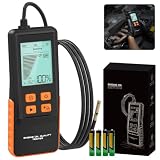
- 【Transmission & Oil Temperature Measurement】: Insert the probe into the oil reservoir to measure light transmission, which provides a clear visual indicator of oil impurities or contamination. The built-in temperature sensor simultaneously measures and displays the current oil temperature, helping you assess engine performance. Temperature range: -10°C to 125°C (14°F to 257°F).The engine oil quality tester determines the degree of engine oil degradation based on light transmittance (0%–100%). Below 30%: Oil needs to be replaced,30% - 60%: Replacement is recommended,60% - 100%: Oil is in good condition.
- 【Dual Fuel Type Compatibility】:This engine oil quality tester supports simultaneous detection of both gasoline and diesel engine oil types, compatible with multiple lubricant standards. It works with most commercial gasoline and diesel engine lubricants, helping you monitor lubricant condition. Switch between Celsius/Fahrenheit display modes to show real-time oil temperature, ensuring operation within safe temperature ranges (-10°C to 60°C).
- 【50" Flexible PTFE Probe & Rugged Build】:The 800mm oil-resistant Teflon hose reaches deep into various engine oil compartments. It provides outstanding oil resistance, oxidation resistance, and corrosion resistance. The high-precision photoelectric sensor ensures lab-grade accuracy, while the silicone grip provides comfortable, slip-resistant handling.
- 【2.8" Backlit LCD & High-Precision Probe】: The large backlit LCD clearly displays transmittance percentage, temperature, oil type and status indicators for easy reading in bright sunlight or dim workspaces. The probe adopts optical sensing technology to deliver high accuracy and sensitivity. Stable test results are generated in seconds once contacting engine oil for fast, reliable readings without long waiting.
- 【User-Friendly Design & Full Accessory Package】: This engine oil quality tester has a large 2.8-inch backlit LCD screen for clear readouts under bright sunlight or dim working conditions. It comes with an ergonomic non-slip silicone handle for comfortable one-handed operation. Compact and lightweight at only 0.44 lbs, it is simple to carry and store. An auto-shutoff function triggers after 5 minutes of inactivity to save battery power. The package includes 4 AAA batteries for immediate use and an English user manual.
For state and local government users in Victoria, the Victorian Government describes Vic3D as a 3D viewer with date-and-time shadow display, measurement, line-of-sight and viewshed tools, and proposed-massing sketches. This is a government-oriented service example, not an assurance of general public access.
Compare proposal versions or assessments consistently
When reviewing revisions or deciding whether an assessment addresses your concern, compare the same factors each time:
- Baseline: existing conditions and, where relevant, approved but unbuilt developments, distinguished from the proposal.
- Affected place or viewpoint: the actual window, outdoor area, public space, observer point, or target view that matters.
- Time and season: dates, local time zone, intervals, and duration, checked against the authority’s requirements and the use of the affected place.
- Magnitude: added shadow area and duration, or the extent to which a specified target or view becomes obscured.
- Model inputs: heights, terrain, trees, surrounding buildings, camera position, and the correct proposal version.
- Evidence type: an illustrative image or interactive display versus saved, quantified analysis; neither replaces local planning judgment.
Ask the planning authority before drawing conclusions
Contact the case officer to ask which local daylight, sunlight, shadow, verified-view, or visual-impact requirements apply; whether the submitted study uses the latest proposal; and whether its context, dates, viewpoints, and affected places match the authority’s scope. Planning criteria, protected-view policies, study formats, and access to 3D tools vary by jurisdiction. A visible impact is a reason to examine the evidence and applicable policy, not by itself a prediction of the planning outcome.
Quick Recap
Product prices and availability are accurate as of the date/time indicated and are subject to change. Any price and availability information displayed on Amazon at the time of purchase will apply.
The Tool Desk
Outbyte PC Repair FREEClear out junk files and repair common Windows errorsFree Scan →Outbyte Driver Updater FREEFix the driver behind crashes, sound loss and screen glitchesFind Drivers →



