Quick wins for a faster PC:
Scan for outdated or missing drivers - takes under a minuteDriver Scan →Clear out junk files and repair common Windows errorsFree Scan →Fix the driver behind crashes, sound loss and screen glitchesFind Drivers →The Ningbo Eco-Corridor shows how a brownfield can become working landscape infrastructure rather than a beautified vacant site. In Ningbo’s Eastern New City, SWA reshaped degraded canals into a 3.3-kilometre chain of rivulets, ponds, marshes and planted edges, then added hills, stormwater landscapes, habitat structures and public routes. The result joined water treatment, flood management, ecological restoration and everyday access in one continuous park system.
ASLA’s award accounts report that the project improved canal water from Class V to Class III and that rarely seen local wildlife returned soon after phase one. Those are project-reported outcomes, not independent long-term monitoring results: the published accounts do not provide sampling dates, testing protocols, species lists, population counts or current maintenance data.
As an Amazon Associate I earn from qualifying purchases.
Ningbo Eco-Corridor at a glance
| Item | Documented detail |
|---|---|
| Location | Ningbo Eastern New City, Ningbo, China, in the Yangtze River Delta |
| Designer and client | SWA for the Ningbo Planning Bureau–East New Town Development Committee; Hui-Li Lee, ASLA, is named lead designer |
| Award | ASLA 2016 General Design Honor Award |
| Corridor length | 3.3 kilometres in the 2013 project narrative; the 2016 award page rounds this to two miles |
| Phase-one area | 56 acres, according to the 2016 award page |
| Planned development context | A six-square-mile mixed-use expansion described in the 2013 account |
| Reported water-quality change | Class V to Class III in the project narrative; ASLA does not publish independent monitoring details on the award page |
| Phase status in published material | The 2016 page says phase two was scheduled to begin “this year,” meaning 2016; the available accounts do not establish later completion or present-day operation |
The project is often described as a “living filter” because its treatment strategy is distributed through land and water. Instead of relying on a single treatment plant or a hard-lined drainage channel, it slows water, exposes it to oxygen and biological activity, filters it through soil and roots, and gives pollutants more opportunities to settle or be processed before water continues downstream. That phrase describes the design intent and the project’s reported performance; it is not a substitute for a published monitoring record.
Windows Errors? Fix Them Before They Spread
Repair common Windows errors and clear accumulated junk for a smoother, more stable PC - no reinstall needed.Free scan · no reinstallCrashes, No Sound, or Screen Glitches?
Random freezes, missing sound and display glitches usually trace back to one bad driver. Find and replace yours safely.Free scan · under a minuteWhy the former brownfield needed a landscape system
Ningbo’s historic canal network supported transportation, irrigation and flood control. At the project site, industrial use had broken that relationship. The 2013 ASLA account describes inadequate pollution controls, untreated factory sewage and stormwater, stagnant canals and dumping of contaminated excavation soil. A dead-end canal could hold polluted water rather than convey it, while compacted or disturbed ground reduced infiltration and habitat.
#1 Best Overall

- 17 IMPORTANT PARAMETERS: The Varify Premium Drinking Water Test Kit offers an unrivaled, complete analysis of your drinking water by testing for 17 essential parameters. This includes crucial tests for chlorine, fluoride, lead, iron, bacteria, and more, ensuring that you're fully informed about the quality of your water. With this extensive range of testing capabilities, you can detect contaminants and imbalances that could affect your health, providing a holistic view of your water's safety.
- PREMIUM QUALITY: Varify stands out with its professional-grade quality, ensuring that every test strip in the kit meets the standards of precision and reliability. Crafted with meticulous attention to detail, this kit is designed to provide you with a dependable and thorough analysis of your water's composition.
- EASY TO USE: Varify's water test strips and Bacteria Test kits feature a user-friendly, color-coded system for quick and precise water quality assessments. With clear color changes indicating various parameters, these strips make complex data easily understandable, ensuring you can evaluate your water's safety effortlessly in just minutes.
- ACCURATE AND RELIABLE: Varify's water test kit comes with 100 strips in 5 separately sealed pouches (20 strips each), preserving freshness and extending shelf life for dependable testing. It also includes 2 easy-to-use bacteria tests that deliver results in 48 hours, ensuring thorough and accurate assessment of your water's safety and cleanliness. This design ensures precision and convenience in monitoring your water quality.
- WATER TESTING KITS THAT GIVE BACK: With every Varify test kit, not only do you secure the safety of your drinking water with our precise and easy-to-use testing solutions, but you also contribute to a global cause. A portion of proceeds goes to Water For Good, fighting water poverty in Central Africa. This means each test not only brings peace of mind to you but also supports #CleanWaterWorldwide, making a real difference in communities in need.
The setting was also changing rapidly. Ningbo’s planning department called for the Eastern New City master plan in 2002. The planned mixed-use area covered six square miles, and the 2013 narrative cited a 2010 Census population of 3.49 million for the wider urban context. That population figure is historical context, not a current estimate. The challenge was therefore larger than cleaning an isolated ditch: a new urban district needed drainage, open space and public routes without carrying the old industrial damage into the next phase of development.
Before settling on a form, the design team and specialist water-quality, wetland and hydrology consultants analyzed site conditions and water movement. Their response treated the corridor as connected infrastructure. Water, soil, topography, planting and circulation were designed to reinforce one another rather than being delivered as separate engineering and park packages.
The three systems that make the corridor work
1. Hydrology: replace dead ends with a connected water sequence
The first move was to replace stagnant, dead-end canals with a slow, meandering sequence of rivulets, streams, ponds and marshland. A winding route lengthens the path water travels and creates changing depths, edges and velocities. Ponds provide places for water to collect; marshes and planted margins provide contact with roots and soils; narrower channels keep the system legible as a connected flow rather than a series of isolated basins.
ASLA’s 2013 narrative says bio-remediation methods were intended to mimic ecological processes and improve canal-water quality. In practical terms, the corridor uses biological surfaces and residence time as part of treatment. Water can settle in slower areas, pass through vegetated edges and encounter oxygenating conditions before moving on. The award account does not publish a complete hydraulic model, detention volume, pollutant-load calculation or operating rule, so those details should not be inferred from the plan alone.
2. Landform: turn excess fill into treatment and protection
Development excavation produced surplus soil. Rather than treating all of that material as waste to be hauled away, the project reused excess fill to shape hills and valleys. The 2013 account says the valleys route, slow, settle, aerate and biologically process water. The 2016 page similarly explains that soil from surrounding development was used to create contours, with valleys managing stormwater.
Rank #2

- Clear Range: This house water testing kit offers clear, easy to read results and acceptable ranges for all substances. The water contaminant tester delivers clear results on any type of water
- Easy to Use: The water hardness test kit for water softener is as easy as adding the water, setting a timer, and reading the results. The pH strips for water testing come with an easy-to-read results guide
- Easy to Understand: The water tester for drinking water comes with a clear guide on the outside of the bottle that lines up with each strip, from alkaline level to soft characteristic readings
- Data Sheet Included: These water testing kits for drinking water include a data sheet to record readings for later analysis. The complete water tester for chemicals has it all
- Peace of Mind: This well water test kit comes with a 17-in-1 test strip and 2 separate bacteria tests to check for coliform and e coli. Knowing what’s in the water for peace of mind is easy
The landform has a second job. Hills frame views, buffer the new urban context and add habitat variety. A raised landform can separate a trail from a water edge, create a dry habitat beside a wet one and make a long corridor feel like a sequence of rooms. The approach is a construction decision as much as a landscape gesture: grading, soil handling and water movement are coordinated so that material removed for buildings helps create the ecological and civic framework around them.
3. Vegetation and habitat: make the edges perform
The planting strategy uses native plant communities, vegetated sloping canal edges, riparian buffers, bioswales and rain gardens. These elements stabilize banks, intercept runoff and provide root zones where water and soil interact. Sloped edges also replace the abrupt boundary of a concrete channel with a broader transition between land and water.
Do these 3 things before closing this tab:
1Repair Windows errors before they cause bigger problems2Scan for outdated or missing drivers - takes under a minute3Clear out junk files and repair common Windows errorsThe 2016 account names logs and perch trees as habitat structures. Those small, deliberate features matter because restoration is not only about planting density. Fallen timber, perches and varied shoreline conditions give birds and other organisms places to rest, shelter and feed. The two ASLA accounts describe planting as supporting both habitat and water treatment, but they do not provide a species-by-species planting schedule or survival survey.
How the “living filter” functions after rain
The corridor’s treatment logic can be understood as a sequence rather than a single device:
- Runoff enters the landscape. Stormwater from the developing district is directed toward valleys, bioswales, rain gardens and channel edges instead of being sent immediately through a sealed pipe.
- Flow slows and spreads. Graded valleys and wider pond or marsh areas reduce velocity, giving sediment and attached pollutants a chance to settle.
- Water meets soil and roots. Vegetated slopes, riparian buffers and wetland planting create surfaces for filtration and biological activity.
- Channels aerate and convey. The meandering watercourse and changing topography keep water moving while introducing conditions that the project narrative associates with aeration and bio-remediation.
- Habitats and public routes share the corridor. Trails, bridges and boardwalks let people see the process without requiring the ecological functions to be hidden behind utility fencing.
This is why the project is better understood as landscape infrastructure than as a conventional park with decorative water. The same grading that creates a view can also hold stormwater; the same planted edge that frames a path can also filter runoff; and the same connected channel that supports habitat can also restore a damaged drainage network.
Rank #3
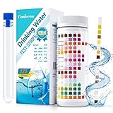
- 🌍 【16-in-1 Water Test Kit】- With Umlecoa water quality test kit, you may know level of Water Hardness, Free Chlorine, Iron, Copper, Lead, Nitrate, Nitrite, Mps, Total Chlorine, Fluoride, Cyanuric Acid, Ammonia Chloride, Bromine, Total Alkalinity, Carbonate, pH easily. Covers main influencing factors which pollute your swimming pool ,hot tub or drinking water quality.
- 🌍【Fast & Accurate Results】- Get accurate results in minutes in just 3 steps. ①Dip an testing strip into water for 2 sec. ②Remove it and hold horizontally for 30-60 sec (Please don't shake excess water off). ③Compare to color chart with up to 99% accuracy. It’s never been this easy to take a drinking water testing, even a child can do it, save your time and money from long trip to laboratory.
- 🌍 【Wide Applicability】- Umlecoa 16 in 1 water test strips can be applied to a wide range of water inspection, including drinking water, pool, hot tub, spa, pond, aquarium and industrial waste water and more water quality test, it is ideal for water testing at home, laboratory or school. For the health of you and your family, please use the professional water test strips to detect water quality standards.
- 🌍 【Home Test Kit】- Package includes: 125 test strips, test tube with cap (help with testing). Ready to use, for your convenience. All kits have safety measures to ensure the quality of your test strips. Economical 125pcs test strips for water in a handy bottle with color card, easy to carry to test anywhere according to your own needs (Tip: Be sure to tighten the cap after taking out the test strip).
- 🌍【Healthy Water & Happy Life】- We promise, we follow a strict quality control on each package and each batch, so you never need to worry about inconsistent or faulty readings on these test strips. If you have any concerns about our water test kit, please contact us now! Umlecoa after-sales service team is online 7*24 hours. Our expert team will provide an efficient and satisfactory solution.
Public access was built into the ecological plan
Visitors can encounter the system through trails, bridges, boardwalks, stepping stones and bird blinds. Educational opportunities are included so that the water and restored habitat remain visible subjects rather than invisible technical works. The routes provide multiple ways to enter and cross the corridor, while overlooks and bird blinds encourage slower observation.
ASLA’s 2016 Awards Jury wrote: “There are so many opportunities to enter and enjoy it. They succeed admirably in making this site feel natural. The materials used for the bridges and walks speak to the industrial past and are adroitly integrated into the park.” The comment identifies an important design balance: access is extensive, but the circulation elements also acknowledge the site’s industrial history through their material language.
The 2013 Awards Jury described the project this way: “The scale is astounding. What sets it apart, is the reality of the analysis. It is carefully considered, realistic, technically sound, and exciting. The rationality is clear and the design makes sense.” The statement points to the project’s central ambition—making ecological processes legible and usable at the scale of a new district.
What the published accounts say about results
Water quality
The 2013 ASLA project narrative reports that the watercourse improved canal water from Class V to Class III. It describes Class III as suitable for ecological restoration and recreation. This is a claim made in the award narrative. The published material does not include sampling dates, laboratory methods, locations, pollutant concentrations, seasonal comparisons or independent confirmation, so the result should not be presented as a verified long-term water-quality trend.
Wildlife
The 2016 award page says rarely seen local wildlife returned shortly after phase one was completed. The account does not name the species, provide a baseline, report population counts or explain a monitoring method. It is therefore best read as an early observation associated with the completed landscape, not proof of quantified or durable biodiversity recovery.
Free tools Windows power users keep installed
One-click scans. No signup required.
Rank #4

- Every test counts: Water insecurity can cause health problems, and having suffered from it myself, I am keenly aware that I do not want to see any more families affected. HEVEIS is committed to encouraging families in the United States to be aware of water quality issues and to take steps to test water quality regularly and resolve problems in a timely manner. To eliminate the physical effects of water quality. Small actions add up to a big difference, so take action now for the health of you and your family
- Complete and comprehensive: Water testing kits for drinking water offers the most extensive and comprehensive drinking water test kit, so if you want to test your drinking water quality quickly and comprehensively, it's all you need! Once you have it, you'll have peace of mind for the whole family
- Easy to use for everyone: No need to be a specialist, even a child can do it independently; results are obtained in 3 simple steps and the home water test kit is accompanied by clear graphic instructions
- Easy-to-read, real-time record: Still worried about the bottle's colorimetric difficulties and indicator results you can't remember? The water quality test kit is equipped with an independent color comparison chart and record card; by comparing the test strip with the color comparison chart, the results are instantly available and can be recorded on the record card immediately. The record card is also convenient for later analysis of water quality
- In-depth understanding of water quality: Based on actual test results and compared to the EPA standards book, you can clearly understand the meaning and implications of each indicator to help protect your and your family's health. The drinking water testing kit includes EPA standards and detailed descriptions of each indicator. Please contact us if you require a numerical description
Extent and phasing
Phase one covered 56 acres. The 2016 page says work on phase two was scheduled to begin “this year,” referring to the page’s 2016 setting. The available award accounts do not establish whether that later phase was completed, how the site is maintained today or whether the reported water and wildlife conditions have persisted.
Independent reader supportYour contribution helps us test, update, and keep practical guides available for everyone.What construction and planning teams can learn from Ningbo
Start with a systems survey, not a planting palette
The project team analyzed water movement, wetland conditions and water quality before fixing the design. A comparable brownfield project should map inflows, outfalls, standing-water zones, soil disturbance, contamination pathways, flood levels and existing habitat. Plant selection comes after those constraints are understood.
Make material reuse part of the performance brief
Ningbo’s hills and valleys demonstrate how excavation fill can become useful infrastructure. Reuse is not automatically safe: contaminated material requires characterization, separation and regulatory handling. Where testing permits reuse, the grading plan should state where material goes, what it supports and how it affects drainage, access and long-term settlement.
Give water more than one treatment opportunity
A single basin can fail when it clogs, bypasses or receives more flow than expected. Ningbo distributes functions across channels, ponds, marshes, valleys, bioswales, rain gardens and planted edges. A project brief should identify each element’s role—conveyance, detention, sediment settling, infiltration, aeration, habitat or public access—and define how those roles connect during ordinary storms and larger events.
Design habitat as structure, not decoration
Native plant communities are important, but the project also uses logs, perch trees, varied banks and wetland conditions. Designers should specify shelter, nesting or perching opportunities, seasonal water levels and maintenance access alongside planting quantities. Habitat claims are strongest when they are paired with a baseline and repeatable monitoring plan.
Best Value

- The Earth Force Low Cost Water Monitoring Kit can be used to test fresh, brackish, or saline aquatic environments.
- This complete kit includes a manual with step-by-step, diagrammed instructions; an easy-to-use laminated color chart, and all the necessary apparatus and non-hazardous TesTabs to test ten water samples (three samples for coliform).
- A popular, economical tool for learning the basics of water quality.
- Students will have fun analyzing sample water for eight different test factors.
Plan access around sensitive areas
Trails, bridges, boardwalks, stepping stones and bird blinds can turn restoration into a public asset, but routes should be located so visitors do not compact wetland soils or disturb breeding areas. The public realm should reveal the process while preserving refuges where wildlife can avoid people.
Separate award claims from post-occupancy evidence
Ningbo’s published award pages are valuable records of design intent, construction scope and early reported outcomes. They are not a substitute for post-occupancy data. A new project should budget for baseline sampling, seasonal water testing, sediment checks, vegetation survival surveys, wildlife observations, flood-event records and maintenance reporting, with dates and methods documented so results can be compared over time.
How to compare Ningbo with another urban restoration
Performance comparisons are meaningful only when projects are compared on equivalent evidence. Use the following framework:
Recommended Free Tools
| Comparison question | What to document |
|---|---|
| Starting condition | Industrial history, sewage or stormwater inputs, stagnant water, dumping and verified contamination |
| Water-treatment approach | Channels, wetlands, ponds, bioswales, rain gardens, soil processes, detention and discharge controls |
| Habitat strategy | Native communities, bank profiles, habitat structures, target species and protected refuges |
| Flood and stormwater function | Catchment size, design storms, storage volumes, conveyance routes and overflow behavior |
| Public use | Trail and bridge network, viewing areas, educational features, accessibility and conflict management |
| Scale and phase | Corridor length, restored area, construction phases and completion dates |
| Evidence quality | Baseline data, sampling protocol, monitoring duration, independent review and maintenance records |
On those criteria, Ningbo offers a strong example of integrated design, but the award accounts do not supply the comparative performance dataset needed to rank it against another restoration. The most defensible conclusion is narrower: the project demonstrates a coherent way to combine brownfield remediation goals with urban growth, while its long-term ecological performance remains insufficiently documented in the published material.
Why the Ningbo example still matters
The project’s lasting lesson is organizational as much as visual. Hydrology, grading, planting and circulation were conceived as one connected corridor for a new district. Polluted canals were not treated as an isolated environmental liability, and public space was not postponed until after engineering decisions. The design used development fill to shape land, reshaped water into a living sequence, planted the edges for treatment and habitat, and made the process accessible through paths and crossings.
For construction and landscape teams, that sequence provides a practical brief: diagnose the damaged system, keep water moving through a chain of treatment landscapes, reuse safe site materials, vary landform and habitat, and measure outcomes after opening. Ningbo’s ASLA award accounts report promising early changes, but responsible evaluation requires acknowledging exactly what those accounts do and do not establish.
Quick Recap
Product prices and availability are accurate as of the date/time indicated and are subject to change. Any price and availability information displayed on Amazon at the time of purchase will apply.

