Stop work in the disputed area, preserve both sets of evidence, and verify what each source actually proves. A utility map may be an old record drawing, while an on-site scan may show a geophysical response without proving a pipe’s depth, identity, or ownership. Treat the conflict as unresolved until the applicable 811 process, private-utility coverage, qualified investigation, and—where needed—nondestructive exposure establish a defensible location.
This guidance describes U.S. practice. One-call procedures, waiting periods, tolerance zones, marking rules, and legal duties vary by state and locality. A safety pause is prudent, but the sources cited here do not create one universal stop-work statute.
As an Amazon Associate I earn from qualifying purchases.
First response: pause, preserve, and define the conflict
Pause excavation or design decisions at the disputed point
Do not resolve conflicting evidence by automatically trusting the map or the scan. Keep people and equipment out of the area where the planned work could reach the utility until the conflict is investigated. If work must continue elsewhere, establish a clearly marked exclusion area and brief the crew on its limits.
Quick wins for a faster PC:
Fix the driver behind crashes, sound loss and screen glitchesFind Drivers →Repair Windows errors before they cause bigger problemsFix Now →Scan for outdated or missing drivers - takes under a minuteDriver Scan →Preserve the conditions that produced the disagreement. Photograph markings and visible features, record the date and weather or ground conditions, and retain the utility records, 811 ticket, responses, scan method, equipment settings if known, operator notes, and any survey files. A later investigator needs to know not only what was found, but how and when it was found.
#1 Best Overall
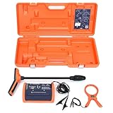
- PROFESSIONAL-GRADE UTILITY LOCATOR – Locate underground electrical lines, telecom cables, irrigation wires, and metallic pipes with precision over 1 mile (1.6 km) and depths up to 20 feet (6 m) with the 551 underground wire locator.
- DUAL FREQUENCIES + INTELLITRACK NOISE REJECTION – Simultaneously transmit two frequencies and eliminate AC interference with proprietary IntelliTrack digital filtering for accurate readings in noisy environments with the 551 cable locator.
- PEAK & NULL RECEIVER MODES – Choose between peak or null response to fine-tune your search and detect anomalies with confidence, even in complex underground environments with 551 buried wire locator.
- FLEXIBLE CONNECTION OPTIONS – Use direct wire connection , inductive clamp, or built-in antenna on 551 wire locator for maximum adaptability on active or inactive systems.
- BUILT FOR THE FIELD – Rugged, IP54-rated, and ergonomically designed with a lightweight receiver and durable case for reliable use in demanding job sites.
Confirm the request’s limits
Read the 811 ticket and each utility owner’s response. Check the exact address or stationing, work limits, requested start date, ticket expiration, and whether every owner in the area responded. A mark outside the ticket polygon, an expired ticket, or a facility owner that did not respond cannot be treated as a complete locate.
Ask the one-call center or utility owner what the response means in that jurisdiction. The legal duty to call 811 before digging remains separate from a design team’s decision to obtain better utility information.
Describe the mismatch precisely
Write down the disagreement in measurable terms: for example, the record drawing places a water main 2 feet east of the proposed trench, while the scan indicates a linear response 6 inches west; or a marked line has no corresponding manhole, valve box, or service connection. “The scan is different” is too vague for a re-locate request or an engineering scope.
Why maps and scans can disagree
Utility-location evidence is not a single category. A record drawing, a surface feature, a paint mark, a geophysical response, and an exposed utility answer different questions and carry different uncertainty.
| Evidence | What it can establish | Important limitation |
|---|---|---|
| Record drawing, as-built, or verbal recollection | Where someone believed a facility was installed, often useful for early planning. | It may be incomplete, outdated, or inaccurate. James H. Anspach, chair of ASCE 38, noted that “Record drawings are not always available or of sufficient detail for design purposes.” ASCE announcement, July 20, 2022 |
| Visible surface feature | A manhole, valve box, hydrant, pedestal, or service entry can help correlate a facility with records. | Features may be buried, moved, mislabeled, or connected to more than one facility. Underground lines can be omitted or plotted incorrectly. |
| Paint, flag, or electronic locate mark | A utility owner’s or locator’s indication of a horizontal path within the applicable locate tolerance. | It does not by itself prove depth, material, condition, ownership, or that every facility was detected. |
| Surface geophysical scan | With an appropriate method, it can indicate a utility’s existence and horizontal position. | Results depend on utility material, depth, soil, moisture, interference, access, instrument settings, and operator interpretation. A response is not automatically a verified identity or depth. |
| Nondestructive exposure | Directly confirms the utility’s actual position and allows measurements of type, size, material, condition, and elevation. | It is localized work that requires a suitable method, traffic and site controls, and proper survey documentation. |
The Federal Highway Administration (FHWA) describes subsurface utility engineering (SUE) as a process that combines records, engineering, surveying, geophysics, communication, and, when appropriate, nondestructive vacuum excavation. The point is not to declare one source infallible; it is to assemble evidence at a level appropriate to the risk.
Rank #2

- Extended trace range over the Leica DD120 with additional low frequencies (512Hz and 640Hz)
- Kit includes DD130 Locator, DA175 1 Watt Signal transmitter, and carry bag which offers a turn key Package for locating underground utilities
- Safely locate underground power, water, gas, and Cable lines
- Automatic pinpointing at depths up to 33 feet (With Sonde - not included) with power, radio, auto modes
- Health check and start up test each time you turn on the unit to ensure proper functionality
Check public locate coverage and private facilities
Repeat or correct the one-call request when necessary
Contact the applicable 811 center before digging and follow its local response and waiting rules. Request a re-locate when marks are missing, damaged, inconsistent with the ticket, or no longer visible; ask the center or utility owner how to handle a conflict rather than moving marks yourself. Keep the new ticket number and response records with the project file.
Do not assume 811 covers every line on private property
Public one-call services generally coordinate participating utility owners. Customer-owned or privately installed facilities—such as lines beyond a utility meter, private water or sewer services, irrigation, site lighting, or internal communications—may require a separate private locate.
The Tool Desk
Outbyte Driver Updater FREEScan for outdated or missing drivers - takes under a minuteDriver Scan →Outbyte PC Repair FREEClear out junk files and repair common Windows errorsFree Scan →Colorado 811 illustrates why local instructions matter: its residential guidance says public utility locates are free, directs people with private utilities to contact a private locate company after confirmation of the public ticket, and describes three business days and an 18-inch tolerance zone for that Colorado guidance. Those figures are not nationwide rules; verify the requirements for your state, municipality, facility type, and project.
When a map shows a private facility that the one-call response does not address, keep both facts in the plan: the public ticket may be complete while the private line remains unverified.
Choose the next step by consequence and uncertainty
Compare the available options against the actual conflict, not against a generic idea of accuracy. The relevant questions are the evidence source and quality level, horizontal and vertical certainty, how identity and ownership will be established, proximity to planned work, consequence if the location is wrong, utility types and area covered, exposure methods, local legal requirements, schedule, cost, and how results will be surveyed and documented.
Rank #3

- ACCURATE UNDERGROUND WIRE LOCATOR. Quickly isolate, trace the path and determine the depth of buried conductors (wires or metallic pipes) over distances of 4,000 feet (1.2 km) and depths of 7 feet (2.2 m) with the 501 underground wire locator.
- EASILY LOCATE AND TRACE Electrical lines, Communications cables, Electric dog fence cables, Fish tape and Metallic pipes, Invisible fence wires, Outdoor or Landscape lighting cables with 501 buried wire locator. Trace Electric, Power, Coax, Telephone, and Utility lines with the 501 underground wire locator.
- EFFICIENT: Save yourself hours to trace buried cables, wires, or pipes. With inductive signal detection, this cable and buried wire locator can be used on active or dead systems, making it quick and easy to trace the path and determine the depth of buried wires and trace metallic pipes.
- COMPLETE PORTABLE KIT: 501 buried wire locator comes with a transmitter assembly, receiver assembly, inductive coupler (clamp), built-in inductive antenna, two 8-foot (2.4 m) test leads with heavy-duty alligator clips, and a durable polyethylene case, making it a complete package for all your location needs.
- CONNECTION OPTIONS: Options for direct connection, inductive clamp, and inductive antenna allow active or dead systems location. Transmitter output and receiver sensitivity are fully adjustable for maximum accuracy.
| Situation | Reasonable next action | What the action does not guarantee |
|---|---|---|
| Marks are missing or the ticket limits are unclear | Correct or repeat the 811 request and obtain all owner responses. | A complete public locate does not identify every private facility. |
| Records and marks differ, but work is distant and consequences are low | Reconcile records with visible features and a qualified surface investigation; adjust the plan only after the conflict is documented. | Records or a scan alone do not establish depth or identity. |
| Planned excavation is close to a suspected line | Use a qualified locator or SUE provider and specify the conflict point, required horizontal and vertical information, and survey control. | A higher quality level is not a promise that every utility will be found. |
| Critical service, congested corridor, or uncertain crossing | Commission an engineered SUE investigation with targeted nondestructive exposure where the decision depends on exact position. | Exposure confirms the points investigated; it does not automatically map an entire route. |
| Design is complete but field evidence conflicts | Hold the affected work, issue a field clarification, and update plans and utility data after verification. | Design documentation does not replace local excavation-notification duties. |
FHWA says the highest information quality is generally most useful at likely conflict points rather than automatically along every foot of a route. Concentrating effort where a wrong assumption could damage a critical service or force redesign can provide a more defensible scope than applying the most intensive method everywhere.
Recommended Free Tools
Understand FHWA’s four SUE quality levels
FHWA presents four quality levels, from records-based information to precise nondestructive exposure. Use them as a way to define risk and scope, not as a guarantee that one instrument or one pass will find every facility. FHWA quality levels
QL-D: existing records and recollections
QL-D uses available utility records or verbal information. It is useful during early route or site planning when the team needs a preliminary picture, but FHWA describes these sources as typically unreliable and limited in accuracy and completeness. A QL-D line should not be treated as a field-verified excavation boundary.
QL-C: visible feature survey correlated with records
QL-C surveys visible features such as manholes or valve boxes and correlates them with records. This can expose obvious inconsistencies—for example, a valve box that does not align with the drawing—but FHWA cautions that underground utilities may still be omitted or incorrectly plotted.
QL-B: surface geophysics and survey
QL-B applies appropriate surface geophysical methods to determine a utility’s existence and horizontal position, then surveys the result to project control. This is often the useful middle step when a conflict is real but widespread excavation is not justified. The method must suit the suspected utility and site conditions; a scan result should not be promoted to a depth or identity claim that the method did not establish.
Free tools Windows power users keep installed
One-click scans. No signup required.
Rank #4

- COMPACT SONDE AND LINE LOCATOR: Perfect for SeeSnake cameras, remote transmitters, or flushable sondes; targets pipes, cables, and energized lines; use with SeeSnake inspection reels or other sondes
- MULTI-DIRECTIONAL TECHNOLOGY: The antenna detects signals from all directions, maximizing signal strength and eliminating false peaks or nulls, ensuring accurate target location
- ENHANCED DETECTION CAPABILITIES: Features 4 Sonde and 5 Line trace mode frequencies; the digital readout delivers real-time signal strength with no false peaks, ensuring fast, accurate locates
- PRECISE TARGETING: Micro-mapping verifies locate positions with on-screen markers for poles in front of and behind your target; depth calculations automatically display when directly over the target
- ALL-IN-ONE PACKAGE: Includes a carrying case for easy transport and protection, plus surface marker chips, an instructional video, an operator’s manual, and 4 C-cell batteries
QL-A: nondestructive exposure
QL-A nondestructively exposes the utility for precise plan and profile mapping. FHWA describes it as the highest level of accuracy presently available and says it can provide details such as type, size, condition, and material. Because it is localized, identify the exact conflict points and the measurements needed before authorizing the work.
Independent reader supportYour contribution helps us test, update, and keep practical guides available for everyone.A practical verification workflow
- Secure the area. Stop the affected excavation or design release, mark the disputed zone, and brief workers and subcontractors.
- Assemble the evidence. Place records, 811 tickets, owner responses, photos, markings, scan files, settings, operator notes, survey control, and site-condition notes in one controlled project record.
- Check coverage. Confirm the ticket limits, expiration, responding owners, and whether private facilities require a separate locate.
- Reconcile surface clues. Survey visible appurtenances and compare them with the record alignment. Do not infer a complete underground network from one feature.
- Define the information gap. State whether the decision needs horizontal position, depth or elevation, utility identity, ownership, size, material, condition, or all of these.
- Select the investigation level. Use targeted QL-B work for horizontal designation where appropriate; specify QL-A exposure where exact position or profile controls the design or excavation.
- Use qualified personnel. For consequential conflicts, engage a qualified SUE consultant, utility surveyor, or private locator and provide the conflict sketch, utility types, access constraints, and required deliverables.
- Survey and verify the result. Tie located or exposed points to project control, record elevations and attributes, photograph the exposure, and identify any assumptions that remain.
- Release work only under the applicable rules. Update drawings, field instructions, and the excavation plan; keep following local 811 notification, tolerance-zone, and communication requirements.
Document the resolution so the next project can use it
ASCE/UESI/CI 38-22, Standard Guideline for Investigating and Documenting Existing Utilities, provides a framework for standardized investigation and documentation. The ASCE publications page lists the current standard information: ASCE utility engineering publications.
Record the source and quality of every utility feature, the date and method of investigation, horizontal and vertical coordinates, identity and ownership confidence, exposed dimensions and condition, unresolved gaps, and the person or organization responsible for the observation. Distinguish an inferred alignment from a surveyed point and a surveyed point from a directly exposed point.
Companion ASCE 75-22 concerns recording and exchanging utility infrastructure data, including location and attributes for new or relocated utilities. Using a consistent format makes the information more useful to future designers, owners, locators, and contractors. The standards announcement describes both documents and their relationship: ASCE 38-22 and 75-22 announcement.
Common mistakes and how to correct them
Trusting the newest-looking source
A fresh scan can still be ambiguous, and an old drawing can still contain the only clue to ownership. Compare provenance and capability, not appearance. Ask what was measured, what was inferred, and what remains unknown.
Best Value

- Easy to Use
- Left / Right Arrows Guide You To Buried Utility
- Single Frequency Locator
- 1W Transmitter
- 1 Year Warranty
Treating a horizontal mark as a complete utility description
Paint or a geophysical line does not automatically establish depth, material, condition, or ownership. Obtain the specific verification needed for the planned work.
Assuming a public ticket includes private services
Check the property boundary and meter-side ownership. If a private line could be in the work area, obtain the separate private locate and retain its report.
Ordering the most intensive work everywhere
QL-A exposure along an entire route may add disruption without improving the decisions that matter. Target higher information quality at crossings, congested corridors, critical services, and other likely conflict points.
Do these 3 things before closing this tab:
1Clear out junk files and repair common Windows errors2Scan for outdated or missing drivers - takes under a minute3Repair Windows errors before they cause bigger problemsUpdating the plan without updating the record
A field fix that is not surveyed and documented becomes the next project’s hidden discrepancy. Close the loop with controlled drawings, coordinates, photographs, and a statement of residual uncertainty.
Design investigation is not a substitute for excavation duties
ASCE 38-22 and an SUE report help a project understand existing utilities; they do not remove statutory or contractual requirements to contact 811, wait the locally required period, respect tolerance zones, maintain marks, and communicate with utility owners. Before breaking ground, confirm the rules that apply to the project’s state, locality, facility owners, and type of work.
When the conflict remains consequential after a repeat locate, the safest professional decision is to keep the area on hold and obtain the level of engineering investigation that answers the unresolved question. Proceed only when the evidence, documentation, and local damage-prevention process support the planned activity.
Quick Recap
Product prices and availability are accurate as of the date/time indicated and are subject to change. Any price and availability information displayed on Amazon at the time of purchase will apply.

