The safest utility construction plan treats underground records, one-call marks and locator readings as evidence to verify—not as proof that a line is exactly where it appears. Start by mapping the entire work area, identifying every utility owner, and improving the information wherever a conflict, depth or elevation matters. Resolve avoidable conflicts in design, obtain the required construction-phase locate, expose lines by safe methods as excavation approaches, protect anything left exposed, and integrate trench, soil, water and atmospheric hazards into the same plan.
This guide is written for U.S. project owners, designers, construction managers and excavators. OSHA rules apply federally, while one-call procedures, ticket timing, tolerance zones, private-utility coverage and state-plan requirements vary by location. Confirm the rules governing your project before work begins.
As an Amazon Associate I earn from qualifying purchases.
What a complete underground-utility plan must accomplish
A plan is complete when the team can answer five practical questions before excavation starts:
PC Slower Than It Used to Be?
A free scan shows the junk files, broken settings and background clutter dragging Windows down - then fixes them in one click.Free scan · Windows 10 & 11Outdated Drivers Are Slowing You Down
One free scan finds every outdated or missing driver and matches the right update for your exact hardware.Free scan · exact hardware match- Which underground installations could be affected by excavation, grading, staging, boring or traffic control?
- Who owns or operates each installation, and how will that owner be contacted?
- How reliable are the horizontal and vertical locations, and what additional investigation is justified?
- What design change, protection, support or relocation will prevent a conflict?
- What will the crew do when the actual field condition differs from the record or surface mark?
OSHA’s excavation standard, 29 CFR 1926.651(b)(2), states: “Utility companies or owners shall be contacted within established or customary local response times, advised of the proposed work, and asked to establish the location of the utility underground installations prior to the start of actual excavation.” That construction-phase duty does not turn old drawings, design investigation or previous marks into a substitute for a current locate request.
#1 Best Overall
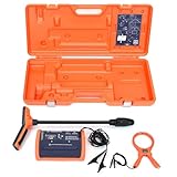
- PROFESSIONAL-GRADE UTILITY LOCATOR – Locate underground electrical lines, telecom cables, irrigation wires, and metallic pipes with precision over 1 mile (1.6 km) and depths up to 20 feet (6 m) with the 551 underground wire locator.
- DUAL FREQUENCIES + INTELLITRACK NOISE REJECTION – Simultaneously transmit two frequencies and eliminate AC interference with proprietary IntelliTrack digital filtering for accurate readings in noisy environments with the 551 cable locator.
- PEAK & NULL RECEIVER MODES – Choose between peak or null response to fine-tune your search and detect anomalies with confidence, even in complex underground environments with 551 buried wire locator.
- FLEXIBLE CONNECTION OPTIONS – Use direct wire connection , inductive clamp, or built-in antenna on 551 wire locator for maximum adaptability on active or inactive systems.
- BUILT FOR THE FIELD – Rugged, IP54-rated, and ergonomically designed with a lightweight receiver and durable case for reliable use in demanding job sites.
1. Define the full work area before collecting records
Draw the proposed excavation, trench, foundations, grading limits, bore or directional-drilling alignment, access roads, laydown areas and temporary work zones. Include places where equipment outriggers, spoil piles, dewatering, shoring, anchors or support vehicles could load the ground or restrict access to a utility.
Identify affected owners and facility types
Build an owner list for electric, gas, communications, water, wastewater, steam, district energy, petroleum and storm systems. Include municipal departments, transportation agencies, railroads, campuses, industrial owners and private facilities. Public one-call systems may not cover customer-owned lines beyond the meter, site lighting, irrigation, private water or sewer, or other privately installed facilities; ask the property owner and facility operators directly.
Collect records, as-builts and prior information
Request utility-owner records, as-built drawings, design plans, permits, survey control, previous pothole logs and available GIS data. Ask for the owner’s contact, emergency number, facility type, operating constraints and requirements for support, shutdown or access. Record the date, document version, stated accuracy and any area the owner could not verify.
Recommended Free Tools
FHWA guidance advises designers to obtain information on underground facilities within and near the project area. Treat those records as investigation inputs. Drawings may omit abandoned lines, show approximate alignments, use a different coordinate system or lack reliable depth. Preserve the original files and maintain a controlled utility base map so later markups do not overwrite the source.
2. Improve utility information where the risk or design requires it
Use Subsurface Utility Engineering (SUE) as a coordinated process, not as a single piece of equipment. FHWA describes SUE as a combination of engineering, surveying and geophysical methods that improves the utility information used to identify conflicts, plan around lines and decide whether relocation is necessary. FHWA references ASCE/UESI/CI 38-22 and 75-22 for utility-investigation and depiction practices; confirm the current editions for your contract and jurisdiction.
Rank #2

- Extended trace range over the Leica DD120 with additional low frequencies (512Hz and 640Hz)
- Kit includes DD130 Locator, DA175 1 Watt Signal transmitter, and carry bag which offers a turn key Package for locating underground utilities
- Safely locate underground power, water, gas, and Cable lines
- Automatic pinpointing at depths up to 33 feet (With Sonde - not included) with power, radio, auto modes
- Health check and start up test each time you turn on the unit to ensure proper functionality
Choose the investigation level by the decision you must make
| Project question | Information needed | Appropriate action |
|---|---|---|
| Could a line be somewhere in the project corridor? | Owner, facility type and approximate horizontal route | Collect owner records, compile available mapping and perform appropriate geophysical locating. |
| Will the proposed alignment, footing or trench intersect it? | More dependable horizontal position and facility identity | Coordinate SUE, survey control and targeted verification before finalizing the design. |
| Does grade, clearance or crossing order matter? | Actual elevation or depth at the conflict point | Use a survey and nondestructive test holes to expose and measure the facility. |
| Can the line be protected in place? | Material, size, condition, ownership and operational constraints | Have the owner review the exposure and approve support, protection, shutdown or relocation. |
| Is a trenchless route safe? | Continuous route awareness, crossing locations and verified depth | Perform route-specific review, field inspection and potholing before drilling. |
There is no universal cost threshold that selects one investigation method. Compare the consequence of a strike, the probability of an unknown line, the precision required by the design, available access, schedule and the ability to move the work. A relatively small number of targeted test holes can answer a critical elevation question, while a broad corridor with uncertain records may justify a larger SUE effort.
Use test holes when records are not enough
FHWA describes a test hole as a nondestructive exposure used to positively locate and identify a facility. Depending on conditions, methods can include hand excavation, vacuum trucks and air knives. Plan the excavation, spoil handling, traffic control and restoration before exposing the line. Survey the exposed point into the project coordinate system and record depth, size, material, direction and owner identification.
Do these 3 things before closing this tab:
1Repair Windows errors before they cause bigger problems2Fix the driver behind crashes, sound loss and screen glitches3Clear out junk files and repair common Windows errorsDo not assume a test hole at one point proves a straight or constant-depth alignment. Use enough verification points to support the design decision, especially where a line changes direction, crosses the proposed work, rises toward a structure or may sag between supports.
3. Resolve conflicts during design, not during excavation
Overlay the best available utility information on the proposed alignment, grades, structures, excavation footprints and temporary works. Mark confidence and uncertainty on the plan so reviewers can distinguish a surveyed exposure from an approximate record.
Options for a probable conflict
- Avoid it: shift the alignment, move a structure, alter the trench width or change the crossing location.
- Change geometry: revise depth, grade, bend locations, foundation type or excavation sequence while maintaining required clearances.
- Change method: evaluate a trenchless or staged installation only after verifying the route and constructability.
- Protect in place: define owner-approved support, bridging, isolation, temporary restraint and inspection requirements.
- Relocate: develop a written scope, outage or bypass plan, design responsibility, schedule and restoration requirements with the owner.
FHWA identifies avoidance and better utility information as ways to reduce conflict-driven redesign, delay and unexpected encounters. The sources do not establish a universal percentage saving, so do not present a numerical benefit without project-specific evidence.
Rank #3

- ACCURATE UNDERGROUND WIRE LOCATOR. Quickly isolate, trace the path and determine the depth of buried conductors (wires or metallic pipes) over distances of 4,000 feet (1.2 km) and depths of 7 feet (2.2 m) with the 501 underground wire locator.
- EASILY LOCATE AND TRACE Electrical lines, Communications cables, Electric dog fence cables, Fish tape and Metallic pipes, Invisible fence wires, Outdoor or Landscape lighting cables with 501 buried wire locator. Trace Electric, Power, Coax, Telephone, and Utility lines with the 501 underground wire locator.
- EFFICIENT: Save yourself hours to trace buried cables, wires, or pipes. With inductive signal detection, this cable and buried wire locator can be used on active or dead systems, making it quick and easy to trace the path and determine the depth of buried wires and trace metallic pipes.
- COMPLETE PORTABLE KIT: 501 buried wire locator comes with a transmitter assembly, receiver assembly, inductive coupler (clamp), built-in inductive antenna, two 8-foot (2.4 m) test leads with heavy-duty alligator clips, and a durable polyethylene case, making it a complete package for all your location needs.
- CONNECTION OPTIONS: Options for direct connection, inductive clamp, and inductive antenna allow active or dead systems location. Transmitter output and receiver sensitivity are fully adjustable for maximum accuracy.
Document the design decision
For every utility that could affect the work, show the source of location information, confidence level, planned clearance, crossing detail, responsible owner and trigger for additional verification. Add hold points before final design release and before excavation at each high-consequence crossing. If the design relies on an owner shutdown, support detail or relocation, obtain written confirmation rather than treating a meeting comment as authorization.
4. Complete the construction-phase one-call process
Before actual excavation, submit the required request through the local one-call center, commonly reached through 811, and separately contact owners whose facilities are not covered or whose procedures require direct notice. Verify the local rules for:
- minimum notice and response time;
- ticket life, renewal and refresh requirements;
- marking colors, tolerance zones and hand-digging limits;
- positive-response or no-response escalation;
- emergency work and after-hours contacts;
- private utilities and customer-owned facilities; and
- special requirements for boring, demolition, agricultural work or state transportation corridors.
Keep the ticket number, request polygon, submission time, owner responses, photographs and mark-out date in the project record. A design-stage locate or an old ticket does not satisfy the need for a current request tied to the work that will actually disturb the ground.
Interpret marks as approximate information
Walk the site with the plans and marks together. Look for meters, valve boxes, manholes, poles, hydrants, service risers, pavement patches, warning signs and building penetrations that indicate a facility the records do not show. If marks conflict with records, stop and escalate to the owner or qualified locator; do not average the two positions or choose the one that is more convenient.
5. Verify and expose utilities as excavation approaches
Establish the exact location by safe means before the excavation reaches the estimated utility position. The method depends on the facility, soil, depth, access and owner requirements. Hand excavation, vacuum excavation and air-knife methods can expose a facility without the impact of conventional mechanical digging. OSHA notes that hydro-vacuum methods can be acceptable when properly adjusted to avoid damaging the utility, with particular care around vulnerable electrical lines.
The Tool Desk
Outbyte Driver Updater FREEFix the driver behind crashes, sound loss and screen glitchesFind Drivers →Outbyte PC Repair FREEClear out junk files and repair common Windows errorsFree Scan →Rank #4

- COMPACT SONDE AND LINE LOCATOR: Perfect for SeeSnake cameras, remote transmitters, or flushable sondes; targets pipes, cables, and energized lines; use with SeeSnake inspection reels or other sondes
- MULTI-DIRECTIONAL TECHNOLOGY: The antenna detects signals from all directions, maximizing signal strength and eliminating false peaks or nulls, ensuring accurate target location
- ENHANCED DETECTION CAPABILITIES: Features 4 Sonde and 5 Line trace mode frequencies; the digital readout delivers real-time signal strength with no false peaks, ensuring fast, accurate locates
- PRECISE TARGETING: Micro-mapping verifies locate positions with on-screen markers for poles in front of and behind your target; depth calculations automatically display when directly over the target
- ALL-IN-ONE PACKAGE: Includes a carrying case for easy transport and protection, plus surface marker chips, an instructional video, an operator’s manual, and 4 C-cell batteries
Safe exposure sequence
- Review the current one-call response, owner instructions, drawings, marks and planned excavation limits at the pre-task meeting.
- Set out the tolerance zone and establish a controlled exclusion or hand-excavation area as required locally.
- Approach the estimated line using the approved method; do not swing a mechanical bucket into an unverified mark.
- Expose enough of the facility to determine its route, depth, size and condition for the immediate work. Obtain additional exposures where the line bends, changes elevation or crosses the excavation.
- Survey and photograph the exposure, identify the owner and update the utility plan and daily briefing.
- Install owner-approved support, shielding or protection before removing surrounding soil or placing loads nearby.
- Backfill and restore the exposure using the owner’s requirements, or maintain a controlled opening with barriers and inspection if the work sequence requires it.
Surface paint, flags, records and locator readings do not guarantee exact position or depth. OSHA specifically cautions that typical underground locators may not provide depth information. Never infer depth from signal strength alone.
Protect exposed installations
An exposed pipe, cable or conduit can fail because of loss of soil support, equipment contact, vibration, thermal movement or a load placed above it. Coordinate support and protection with the owner. Keep spoil, materials and vehicles outside the area where they could surcharge the line or collapse the excavation. If the facility is damaged, contacted, unsupported or found in a materially different location, stop work, secure the area and follow the owner’s emergency procedure.
6. Give horizontal directional drilling its own verification plan
HDD can reduce open excavation but does not remove utility-strike risk. The drill path may pass below a line that is not visible at the surface, and a locator’s indication may not establish depth. Before drilling, OSHA recommends a route-specific review that includes:
- checking the latest drawings and utility-owner information;
- contacting owners directly where possible;
- comparing records with one-call surface marks;
- walking the entire alignment for meters, manholes, valve boxes, service connections and other clues;
- inspecting entry, exit, staging and possible pullback areas; and
- potholing or using other precautions to verify hidden utilities and depth at crossings and risk points.
Set the drill profile from verified elevations, define allowable deviation and identify who can stop the operation. Include a response plan for an unexpected utility, loss of tracking, drilling-fluid return, damaged line or inability to maintain separation. Do not begin a bore because the surface appears clear.
Quick wins for a faster PC:
Scan for outdated or missing drivers - takes under a minuteDriver Scan →Clear out junk files and repair common Windows errorsFree Scan →7. Integrate excavation safety and changing conditions
Utility coordination is only one part of excavation planning. A competent person must evaluate soil conditions, protective systems and changes that could increase hazards. OSHA’s excavation guidance calls for inspections before work, daily before each shift, as needed during the shift and after events that increase hazards.
Best Value

- Easy to Use
- Left / Right Arrows Guide You To Buried Utility
- Single Frequency Locator
- 1W Transmitter
- 1 Year Warranty
Include these checks in the daily plan
- soil classification and the selected sloping, benching or shoring system;
- condition of protective systems, access and egress;
- water accumulation, pumping and potential loss of soil support;
- hazardous atmospheres where the excavation could contain contaminants, displace oxygen or accumulate gas;
- weather, vibration, traffic and nearby structures;
- utility support, clearance and protection as the excavation advances; and
- changes in crew, equipment, sequence or site conditions that require a new briefing.
Apply the current federal OSHA standard or applicable state-plan rule, plus the project safety plan and owner requirements. A competent-person inspection does not replace utility-owner coordination, and a utility locate does not replace trench-protection decisions.
8. Assign responsibilities and preserve the evidence
Put one person in charge of the utility coordination log, but assign actions to the people who control them. The owner or designer should define the investigation needed for design. The construction manager should confirm tickets, hold points and owner approvals. The excavator should brief the crew, maintain marks, verify exposures and stop when conditions differ. Utility owners should provide available records, mark facilities, approve protection and explain emergency contacts.
Maintain a location record that includes plans and revisions, owner correspondence, one-call tickets, mark-out photographs, SUE reports, test-hole coordinates and measurements, daily inspection forms, approvals, incidents and as-built updates. Give field crews the current version at the work face; a correct record stored only in the office cannot protect the excavation.
Free tools Windows power users keep installed
One-click scans. No signup required.
Common planning failures and the corrective action
| Failure | Why it fails | Corrective action |
|---|---|---|
| Relying on an old drawing | Records can be incomplete, approximate or outdated. | Obtain current owner information and verify critical locations in the field. |
| Using a design locate as the excavation ticket | Construction conditions, timing and legal requirements are different. | Submit a current one-call request and follow local renewal rules. |
| Assuming paint proves depth | Marks generally communicate approximate horizontal location; locators may not provide depth. | Use safe exposure and survey the facility where depth matters. |
| Calling only public owners | Private service lines may not be in the one-call database. | Ask property owners and facility operators about private lines and arrange direct locating. |
| Starting HDD after a surface walk | Hidden crossings and inaccurate depth can remain. | Review the full route and pothole at crossings and other risk points. |
| Leaving an exposed line unsupported | Loss of soil support or equipment contact can damage it. | Use an owner-approved support and protection detail before proceeding. |
| Continuing after a discrepancy | The plan no longer describes actual conditions. | Stop, secure the area, notify the responsible owner and revise the plan. |
Field-ready planning checklist
- Work limits include excavation, bore, staging, access and temporary works.
- Every public and private utility owner has been identified.
- Records and as-builts are dated, controlled and marked with uncertainty.
- SUE, survey or test holes have been selected where risk or design precision warrants them.
- Conflicts have an avoidance, redesign, protection or relocation decision.
- The construction-phase one-call request is current and local requirements are confirmed.
- Marks, records and field clues have been compared.
- Verification and exposure methods are approved before excavation approaches a line.
- Owner-approved support, protection and emergency contacts are available.
- HDD routes have verified crossings and depth information where needed.
- Soil, protective systems, water, atmosphere, access and inspection requirements are in the daily plan.
- Stop-work triggers and documentation responsibilities are understood by the crew.
Frequently Asked Questions
Does calling 811 guarantee that every underground line will be found?
No. One-call marks are approximate, and coverage may not include private or customer-owned facilities. Use the current ticket together with owner coordination, site clues and safe verification as excavation approaches.
When should a project use SUE instead of ordinary utility records?
Use SUE when records are uncertain, a proposed facility is close to an existing line, elevation or clearance controls the design, or the consequence of a conflict is high. It combines engineering, surveying and geophysical methods rather than relying on one locator reading.
What is potholing used for?
Potholing is a nondestructive test-hole method used to expose and positively locate and identify a facility. It can establish actual horizontal position and depth at a critical point so the design or crossing sequence can be adjusted.
Can a standard underground locator tell me how deep a utility is?
Not reliably in every situation. OSHA notes that typical locators may not provide depth information, so verify depth by an appropriate safe exposure method when elevation matters.
What’s actually slowing this PC down?
Pick the symptom - the matching free tool is one click away.
What should an excavator do when a utility is not where the plan or mark indicates?
Stop the affected work, keep people and equipment clear, secure the excavation, notify the responsible supervisor and utility owner, and obtain a revised location and protection decision before proceeding.
Quick Recap
Product prices and availability are accurate as of the date/time indicated and are subject to change. Any price and availability information displayed on Amazon at the time of purchase will apply.

