The Tool Desk
Outbyte Driver Updater FREEScan for outdated or missing drivers - takes under a minuteDriver Scan →Outbyte PC Repair FREEClear out junk files and repair common Windows errorsFree Scan →Make a park path more usable by first identifying the route type and local rules, then designing for a firm, stable surface, sufficient clear width, manageable running and cross slopes, passing spaces, rest intervals, and continuous maintenance. The U.S. Access Board’s federal benchmarks are useful for planning, but they are not universal: confirm the requirements adopted by the authority and jurisdiction governing your park before design or construction.
These features are intended to support people with disabilities. They will often make pushing a stroller easier too, but no standard guarantees that every stroller, wheelchair, season, or surface condition will work for every user.
As an Amazon Associate I earn from qualifying purchases.
Start by identifying what kind of path you are designing
Numbers are meaningful only after the route has been classified. A pedestrian route through a park may be regulated differently from a route connecting facilities or a general accessible route in another covered setting.
| Route category | Typical role | Why classification matters |
|---|---|---|
| Outdoor recreation trail | A pedestrian route developed primarily for outdoor recreation. | Trail provisions and outdoor-setting exceptions may apply. |
| Outdoor recreation access route (ORAR) | A route connecting accessible elements, spaces, and facilities within camping and picnic facilities, viewing areas, and trailheads. | The ABA Standards specify ORAR requirements for width, passing, slopes, cross slope, resting intervals, surfaces, and obstacles. |
| General accessible route | A route connecting accessible elements and spaces in other covered settings. | It has separate technical criteria and should not automatically be treated as an ORAR. |
The U.S. Access Board describes the current guidelines covered by its guidance as having been issued in 2004. Treat the dimensions below as technical requirements from the applicable standard, not as population statistics or universal design rules for every country. A new route, an alteration to an existing route, and a route in a different jurisdiction may each require a different review.
#1 Best Overall

- VERSATILE DIGITAL ANGLE GAUGE AND LEVEL: Measure angles, check relative angles with zero calibration feature, or use as a digital level with ease
- HIGH VISIBILITY AND AUTO-ROTATING DISPLAY: Reverse contrast display improves visibility in low light conditions and automatically rotates when upside-down for easy viewing
- STRONG MAGNETIC BASE: Attach to ferromagnetic surfaces like pipe, electrical conduit, miter saw blades for woodworking, vents, ducts, and more for convenient hands-free operation
- V-GROOVE EDGES: Ensure optimal alignment on conduits and pipes for bending and alignment tasks
- WIDE MEASUREMENT RANGE: Measure between 0-90, or 0-180 degrees - useful when accounting for springback when bending conduit
Build a project brief before choosing materials
Record the route’s purpose, endpoints, expected users, terrain, climate, drainage pattern, construction type, and maintenance resources. A path that is firm in dry weather but ruts after a storm is not a dependable accessible route between maintenance visits. Likewise, a route that meets a width target on paper may fail when signs, benches, railings, vegetation, snow, or maintenance equipment occupy the tread.
- Map every connection: parking, entrances, toilets, picnic tables, play areas, overlooks, trailheads, and other accessible features.
- Mark steep ground, culverts, bridges, retaining walls, stream crossings, roots, and locations where the route must narrow.
- Measure the existing running slope, cross slope, clear width, surface condition, and drainage before setting a design line.
- Identify the authority that adopted the requirements for the site and determine whether the work is new construction or an alteration.
- Set a maintenance interval and test whether the proposed surface remains firm and stable through expected weather and normal wear during that interval.
Choose a firm, stable surface that fits the site
“Firm” means the surface resists indentation. “Stable” means it withstands expected weather and normal wear between planned maintenance. Both qualities matter: a hard-looking path can still be unstable if loose aggregate migrates under wheels, while a smooth surface can become unusable when it softens or develops ruts.
The Access Board states that a firm and stable surface does not always mean concrete and asphalt. Highly developed areas may suit concrete or asphalt. Less developed settings may use crushed stone, fine crusher rejects, packed soil, soil stabilizers, or other natural materials when the completed surface performs adequately for the location. These are options to evaluate, not guarantees; suitability varies by soil, rainfall, freeze-thaw cycles, drainage, use, and maintenance.
Quick wins for a faster PC:
Fix the driver behind crashes, sound loss and screen glitchesFind Drivers →Clear out junk files and repair common Windows errorsFree Scan →Scan for outdated or missing drivers - takes under a minuteDriver Scan →| Surface approach | Where it may fit | Questions to resolve before approval |
|---|---|---|
| Concrete | Highly developed areas and routes needing a consistently hard tread. | Will joints, settlement, roots, or drainage create abrupt changes? Can the route be repaired without creating a lip? |
| Asphalt | Highly developed areas where a continuous paved surface is appropriate. | How will heat, cracking, edge breakup, and resurfacing affect firmness and cross slope? |
| Crushed stone or fine crusher rejects | Some less-developed settings where a compacted natural-looking finish is desired. | Will particles remain locked in place during rain and heavy use? Is edging or periodic replenishment needed? |
| Packed soil or soil stabilizer | Some natural-looking routes with suitable soil and a realistic maintenance plan. | Can the treated soil resist rutting, erosion, and soft spots through local weather? |
| Other natural materials | Sites where the material can meet the required performance without excessive maintenance. | Has the exact material been evaluated under the site’s expected conditions rather than assumed to be equivalent to a paved surface? |
Designers are encouraged by the Access Board to investigate options consistent with the site’s level of development and requiring as little maintenance as possible. Before opening the route, inspect for loose or displaced material, soft patches, ruts, ponding, erosion, and transitions that could catch a small caster or stroller wheel. Recheck after severe weather and at the interval specified in the maintenance plan.
Rank #2
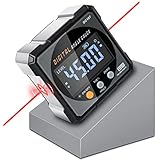
- Nivel Digital Level with Laser - (Class II laser, Output<5mW) L2.4in, W2.4in, H1.2in, portable pocket size with matching belt bag. ±0.2° precise microprocessor with automatic inversion when upside down. 4*90° measurement can be used at many angles and can be zeroed at any angle for comparison.
- Craftsman's Choice - Not only the baseboard, but also the strong magnetic upgrade at the four sides. Never slide on the table saw blade or any metal surface. Magnetic feature and lasers are great advantages for measuring, cutting, leveling in woodworking renovations and building furniture.
- Save time and effort hanging decorations - Dual lasers are great helper for horizontal and symmetrical installation. Furthermore, this digital leveler tool maybe a great gift for father's day, birthdays, Christmas.
- This inclinometer, digital angle finder comes complete with a USB-C charging cable for the internal 340mAH rechargeable battery. It also has dust-proof and IP67 waterproof performance with bright red backlight. Even in garage, with the door open and the sunshine pouring in, you can easily read the display.
- Technical Parameters - Material: aluminum alloy| Measuring range: 4*90°| Resolution: 0.05°| Accuracy: ±0.2°| Repeatability: 0.1°| Power supply: 3.7V lithium battery| Working temperature: 14-122℉
Provide enough width and places to pass
ORAR minimum and passing rule
For an ORAR, the federal ABA Standards require at least 36 inches of clear width. “Clear” means usable space, not the distance between nominal path edges. Measure around posts, signs, railings, vegetation, benches, and other obstructions that occupy the travel zone.
When an ORAR is narrower than 60 inches, provide a passing space at intervals no greater than 200 feet. A passing space may be a 60-by-60-inch area or a qualifying T-shaped space. At an intersection used as a T-shaped passing space, align the layout so wheelchair wheels remain in contact with the surface while turning rather than dropping into a gap or soft shoulder.
When to exceed the minimum
Sixty inches of continuous width can let two people pass without waiting for a widened bay. Consider it, or use more frequent passing spaces, on busy routes, boardwalks, elevated paths, routes serving popular overlooks, and paths where users cannot safely step aside. Count stroller traffic, mobility devices, walkers, maintenance access, and seasonal growth when estimating practical width; do not design only for an empty path on opening day.
Do not transfer ORAR dimensions to every route
General accessible routes have their own baseline: at least 36 inches of continuous clear width, with limited reductions to 32 inches at short points and additional clearance requirements at some turns and passing spaces. Those provisions are not a substitute for checking the standard that applies to your park route.
Rank #3

- FOUR SIDES STRONG MAGNETIC — Digital laser level has strong magnets on four sides that firmly adsorb on the measuring object, ensuring accuracy and not easily falling off. Three easily operated buttons can activate the built-in red laser line on both sides, hold the measured value, switch the unit of the measured value and zeroing function to realize relative measurement.
- THREE IN ONE — This tool has the functions of digital level, angle finder and laser lines(Class II, Output<5mW). Visible measurement value avoids staring at the bubbles in the traditional tube and quickly obtains the level status. Two built-in laser liners are convenient and effective to carry out the horizontal and symmetrical work of home decoration. The zero button can effectively realize absolute or relative angle measurement.
- PROVIDE ACCURACY & CONVENIENT — 360°/4×90° measure angle, the measured value on the display is automatically adjusted. The hold button can memorize the measured values is convenient for taking measurements in narrow spaces, inverted situations, and curved pipes. Display value flipped automatically when mounted upside down, with ±0.2° accuracy and 0.05° resolution to ensure accurate measurement every time.
- BACKLIGHT LCD DISPLAY — Digital angle finder with an easy-to-read display for clear measurement results in any lighting conditions. IP54. The palm-sized, compact design of the angle gauge is easy to carry with a black belt loop storage bag, no matter whether indoors or outdoors is convenient to use. 400mAh, rechargeable, ultra-long standby time, the power display for easy charging in time.
- PORTABLE & RELIABLE- Lightweight and heavy-duty digital angle finder tool is easy to carry and use, meets most woodworking, operation, home maintenance and decoration needs. Also a great gift for men at festivals. Coobeast tools have quality assurance, feel free to contact us if there are any problems with the product. We provide you with service for the first time.
Control running slope, cross slope, and drainage
Running slope is the uphill grade
Running slope is measured in the direction of travel. For an ORAR, a section at or below 5% may be any length. A section steeper than 5% and up to 8.33% may be no longer than 50 feet. A section steeper than 8.33% and up to 10% may be no longer than 30 feet. No ORAR segment may exceed 10% running slope.
| ORAR running slope | Maximum length | Design implication |
|---|---|---|
| 5% or less | Any length | Still verify drainage, surface stability, and transitions. |
| More than 5% to 8.33% | 50 feet | Plan a level or compliant resting interval at the top and bottom of the segment. |
| More than 8.33% to 10% | 30 feet | Use only where the site requires it and provide the required intervals. |
| More than 10% | Not permitted for an ORAR segment | Regrade, reroute, or investigate a narrowly applicable exception. |
A digital inclinometer or slope meter can help check grades against the selected criteria. It cannot establish accessibility by itself: surface, width, passing, rest areas, obstacles, route category, and local rules still require separate evaluation.
Cross slope is the side-to-side tilt
Cross slope allows water to leave the path but can make steering and braking difficult when it is excessive. For an ORAR, the general limit is 1:48. On a surface other than concrete, asphalt, or boards, a cross slope up to 1:20 is allowed when necessary for drainage. Use the least cross slope that achieves drainage and apply the rule for the actual surface and route type.
Keep grades measurable in the field
Survey the finished surface, not only the subgrade or a drawing. Check at the start and end of every steep section, through transitions, beside drainage structures, and after final compaction. A short steep spot created by settlement or a utility cover can change the compliance result even when the original profile was acceptable.
Rank #4

- Ultra Small Digital Level Box - Measuring only 35mm in length and width, 20mm in thickness, it's as compact as a half-dollar coin. Carry this convenient tool in your pocket or hang it on your keychain for optimal accessibility. Ideal for magnetic angle finder applications.
- Experience the powerful magnetic convenience of this digital level box. The button side contains powerful magnets, ensuring stable fixing to any metal surface. Perfect for table saw blade angle gauge and other woodworking tasks.
- Enjoy the Clear & Bright Display with backlit feature, providing better visibility in any lighting condition. Whether you're working indoors or outdoors, our digital leveler delivers remarkable precision.
- Embrace the innovative rechargeable technology of our sophisticated digital level box. With a 230mAh Long-Lasting battery and Automatic shutdown after 3 minutes of non-use, this hgh-class tool ensures uninterrupted performance. Convenient Type-C charging adds to its unparalleled convenience. Perfect for woodworkers and professionals seeking a top-tier level.
- With an accuracy of ± 0.2°, it delivers pristine measurements for your projects. Its unique IP67 Water Proof and Dust Proof design ensures reliable performance even in challenging environments. A Prestigious tool for machinists and those in search of unparalleled precision.
Add resting intervals where the grade requires them
For an ORAR, provide a resting interval at the top and bottom of every segment whose running slope exceeds 5%. Each interval must be at least 60 inches long. If it is within the route, it must be at least as wide as the widest adjacent route segment. If it is beside the route, it must be at least 36 inches wide.
The interval’s general slope limit is 1:48 in any direction. For a surface other than concrete, asphalt, or boards, the same drainage allowance up to 1:20 may apply when necessary. Keep the interval clear of posts, bins, interpretive panels, tree roots, and opening doors. Place it where a person can stop without blocking the route or being forced toward a drop-off, moving traffic, or an eroding edge.
Remove barriers beyond the main tread
Accessibility failures often occur at edges and details rather than in the middle of a path. Inspect the entire route for:
Recommended Free Tools
- Surface openings that could trap a small wheel. For ORARs, openings may not allow passage of a sphere greater than one-half inch.
- Vertical changes, lips, loose boards, and transitions. ORAR obstacles are limited to one-half inch in height, with an exception up to one inch for surfaces other than asphalt, concrete, or boards.
- Branches, signs, bollards, fence hardware, lighting bases, and other protruding objects.
- Pinch points at gates, bridges, culverts, retaining walls, and temporary work zones.
- Standing water, washouts, mud, ice, leaf buildup, and material migration after storms.
- Sharp turns or intersections where a user cannot see another person approaching or cannot maintain wheel contact while turning.
- Edges without adequate protection where a small deviation could lead to a drop-off or unstable shoulder.
Keep a record of defects, their location, severity, responsible party, and repair date. Temporary barricades should preserve a usable route or provide a clearly signed alternative rather than forcing users through grass, loose gravel, or a steep detour.
Best Value

- High Precision Measurement for Accurate Results: This digital angle finder delivers ultra-accurate readings with full coverage of 4×90°, allowing easy measurement of absolute or relative angles and inclinations in any situation. With an accuracy of ±0.2°, it’s perfect for precise tasks in woodworking, construction, and table saw operations, ensuring reliable results every time.
- LED Display: Equipped with a large, clear LED display, this angle gauge provides real-time data visibility even in daylight. This feature improves work efficiency for both indoor and outdoor tasks, eliminating struggles with hard-to-read measurements under varying light conditions.
- Powerful Magnetic Base: Magnetic design on all four sides for a solid attachment to metal surfaces - allows totally hands-free use and multi-angle alignment without slipping or moving.
- USB Rechargeable and Auto Shut-Off: Built-in rechargeable battery with USB charging capability ensures easy power replenishment on-site. It includes a data hold function and auto-shutoff after 3 minutes, extending battery life and facilitating continuous use during long work sessions, reducing the hassle of frequent battery replacements.
- Strong and Easy to Use Design: rugged outer shell resistant to impact and daily wear - simple operation with intuitive buttons: short press to turn on, long press to turn off, and ZERO button to reset the Angle.
Use exceptions only after other options are exhausted
Outdoor standards recognize that terrain, prevailing construction practices, or other site conditions can make a particular provision difficult. An exception is not a blanket waiver for a natural setting. Explore rerouting, retaining, bridging, regrading, widening, or changing the surface first. If only one portion is affected, the remaining portions still must meet the applicable requirements.
Document the affected location, the condition that prevents compliance, the alternatives considered, the provision that cannot be met, and the extent of the departure. Have the determination reviewed by the authority responsible for the project. Do not label an entire trail inaccessible merely because one segment is constrained; identify the exact reach, provide accurate user information, and preserve compliant connections where possible.
A practical design and construction workflow
- Define the route. Identify whether it is a trail, ORAR, or general accessible route; list its destinations; and confirm the governing jurisdiction and project type.
- Survey the existing conditions. Measure running and cross slopes, clear width, surface firmness, openings, obstacles, drainage, and potential rest locations. Photograph problem areas and record measurements by station.
- Set the alignment. Avoid unnecessary steep ground, sharp grade changes, drainage crossings, and narrow pinch points. A slightly longer route may produce a more usable grade and reduce retaining work.
- Choose the surface and edge treatment. Match the material to development level, climate, expected traffic, construction impact, and the maintenance interval. Specify compaction, stabilization, drainage, and repair standards rather than naming a material alone.
- Lay out width and passing. Maintain the required clear width after installing signs, rails, planting, lighting, and furniture. Add 60-by-60-inch or qualifying T-shaped passing spaces at the required spacing when an ORAR is under 60 inches wide.
- Resolve grades. Keep ORAR segments within the 5%, 8.33%, and 10% limits and their associated lengths. Add 60-inch-long resting intervals at the top and bottom of sections over 5%.
- Build drainage without creating barriers. Use the least cross slope needed for runoff, protect the tread from erosion, and detail grates, joints, and transitions so they do not create openings or abrupt lips.
- Inspect the finished route. Re-measure grades and width, check surfaces and openings, verify every passing and rest space, and correct construction defects before opening.
- Operate and maintain it. Schedule inspections after storms, freeze-thaw events, heavy visitation, and landscaping work. Repair rutting, settlement, displaced aggregate, vegetation growth, and damaged edges before they become continuous barriers.
Compare route options using the same decision criteria
| Decision factor | Questions for the design team | Evidence to retain |
|---|---|---|
| Route category and jurisdiction | Which standard applies, and has the local authority adopted additional requirements? | Route classification, governing standard, project type, approvals. |
| Running slope | Are steep sections within both the percentage and length limits? | Survey points, profile drawing, grade calculations. |
| Cross slope and drainage | What is the minimum cross slope that prevents ponding without making steering difficult? | Cross-slope readings, drainage details, post-rain inspection. |
| Surface performance | Will the selected material remain firm and stable through expected weather and normal wear? | Material specification, compaction or stabilization method, maintenance interval. |
| Width and passing | Is clear width maintained around all fixtures, and are passing spaces close enough for the expected use? | Dimensioned plan, field measurements, passing-space locations. |
| Construction impact | Will the route require tree removal, retaining walls, bridges, or substantial grading? | Alternatives analysis, environmental and drainage review, cost and maintenance implications. |
There is no universal best surface or alignment. A paved route may be appropriate at a busy, highly developed trailhead, while a stabilized natural surface may fit a less-developed loop if it remains firm and stable under local conditions. The correct choice is the one that meets the applicable requirements and can be maintained as designed.
What’s actually slowing this PC down?
Pick the symptom - the matching free tool is one click away.
Why these improvements help stroller users, with an important qualification
Strollers and wheelchairs share practical needs: a surface that does not swallow small wheels, a path wide enough to avoid collisions, grades that can be controlled while pushing, and rest locations where a caregiver can stop safely. Those overlapping needs explain why an accessible route often feels easier for families with strollers.
The standards cited here explicitly address accessibility for people with disabilities, not a certification that every stroller will perform on every route. Stroller wheel size, load, user strength, weather, and route conditions vary. Describe the route accurately, including surface type, steep portions, narrow points, and seasonal limitations, instead of promising universal stroller access.
Field inspection checklist before opening
- Route type and governing requirements are documented.
- Surface resists indentation and remains stable under expected weather and normal wear.
- Clear width is at least the applicable minimum after all fixtures and vegetation are installed.
- ORARs narrower than 60 inches have passing spaces no more than 200 feet apart.
- Passing spaces provide the required 60-by-60-inch or qualifying T-shaped geometry.
- ORAR running slopes, steep-section lengths, and the 10% maximum have been verified on the finished tread.
- Resting intervals are at the top and bottom of every ORAR segment over 5%, are at least 60 inches long, and have the required width.
- Cross slope meets the applicable limit and drainage does not depend on ponding or erosion.
- Openings, lips, obstacles, protruding objects, gates, and transitions meet the applicable limits.
- Edges, bridges, drop-offs, and temporary controls do not force users into an unsafe detour.
- A named owner, inspection frequency, storm response, and repair procedure are in place.
Bottom line for park owners and contractors
Accessible park paths are created by coordinated decisions, not by paving alone. Classify the route, confirm the local standard, select a surface that will stay firm and stable, preserve clear width and passing opportunities, control both kinds of slope, provide required resting intervals, remove small barriers, and fund the maintenance needed to keep those features working. Apply exceptions narrowly and document them. These steps give wheelchair users a more dependable route and can make many park trips easier for people pushing strollers without overstating what any standard can guarantee.
Quick Recap
Product prices and availability are accurate as of the date/time indicated and are subject to change. Any price and availability information displayed on Amazon at the time of purchase will apply.

