Quick wins for a faster PC:
Fix the driver behind crashes, sound loss and screen glitchesFind Drivers →Repair Windows errors before they cause bigger problemsFix Now →Scan for outdated or missing drivers - takes under a minuteDriver Scan →Start with your closing paperwork: review the preliminary title report or title policy, especially its easement exceptions or Schedule B. Follow each recording reference to the underlying easement document and recorded plat or map in the county land records. Assessor maps and GIS can help you find the parcel, but a blank map does not prove there are no easements.
Start with your closing documents
Look for the preliminary title report, final title policy, deed, and any survey or plat provided when you bought the property. The preliminary report is often a useful starting point, and the title policy’s Schedule B or exceptions may list recorded easements affecting the parcel. Marin County’s guidance and Pinal County’s FAQ both point property owners to title paperwork.
For each entry, note the easement holder or named utility, the document type, recording date, instrument or document number, book and page, and any plat or map reference. These details are the trail to the recorded source. A deed may refer to an easement without reproducing its terms, so do not stop at the deed if it points to a separate instrument or attachment.
Identify the parcel and legal description
Confirm the property’s parcel number and full legal description using the deed and county assessor information. An abbreviated tax description may be useful for finding the parcel, but it may omit the legal details or recording references needed to locate land records. King County’s recorded-documents guidance describes using assessor parcel tools to find legal descriptions and relevant numbers.
The Tool Desk
Outbyte Driver Updater FREEFix the driver behind crashes, sound loss and screen glitchesFind Drivers →Outbyte PC Repair FREERepair Windows errors before they cause bigger problemsFix Now →#1 Best Overall
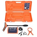
- PROFESSIONAL-GRADE UTILITY LOCATOR – Locate underground electrical lines, telecom cables, irrigation wires, and metallic pipes with precision over 1 mile (1.6 km) and depths up to 20 feet (6 m) with the 551 underground wire locator.
- DUAL FREQUENCIES + INTELLITRACK NOISE REJECTION – Simultaneously transmit two frequencies and eliminate AC interference with proprietary IntelliTrack digital filtering for accurate readings in noisy environments with the 551 cable locator.
- PEAK & NULL RECEIVER MODES – Choose between peak or null response to fine-tune your search and detect anomalies with confidence, even in complex underground environments with 551 buried wire locator.
- FLEXIBLE CONNECTION OPTIONS – Use direct wire connection , inductive clamp, or built-in antenna on 551 wire locator for maximum adaptability on active or inactive systems.
- BUILT FOR THE FIELD – Rugged, IP54-rated, and ergonomically designed with a lightweight receiver and durable case for reliable use in demanding job sites.
Assessor parcel maps and county GIS are useful for orientation and for confirming that you have the right parcel. They are not a complete inventory of easements. Nevada County notes that most private easements do not appear on assessor parcel maps, while Contra Costa County cautions that subdivision maps may omit other easements (Nevada County Assessor FAQs; Contra Costa County Maps & Records).
Search county land records using the references
Use each number or name from your title paperwork to search the county recorder, clerk-recorder, or register of deeds. Look for the referenced deed, separate easement instrument, and related filings. Easements may be recorded separately, included in a deed or its attachments, or depicted on a recorded plat.
Rank #2

- Extended trace range over the Leica DD120 with additional low frequencies (512Hz and 640Hz)
- Kit includes DD130 Locator, DA175 1 Watt Signal transmitter, and carry bag which offers a turn key Package for locating underground utilities
- Safely locate underground power, water, gas, and Cable lines
- Automatic pinpointing at depths up to 33 feet (With Sonde - not included) with power, radio, auto modes
- Health check and start up test each time you turn on the unit to ensure proper functionality
Search methods vary by county. Some indexes rely on grantor and grantee names rather than a street address or parcel number. For example, Marin County says its online index is searchable by name, covers records from 1973 through the previous business day, and does not provide full-document viewing online. Those limits describe Marin County’s system, not every county’s.
If you cannot view the document online, check the recorder’s instructions for ordering copies or requesting archive access. County staff can explain how to search or obtain records; that does not mean they interpret the easement’s legal effect.
Rank #3

- ACCURATE UNDERGROUND WIRE LOCATOR. Quickly isolate, trace the path and determine the depth of buried conductors (wires or metallic pipes) over distances of 4,000 feet (1.2 km) and depths of 7 feet (2.2 m) with the 501 underground wire locator.
- EASILY LOCATE AND TRACE Electrical lines, Communications cables, Electric dog fence cables, Fish tape and Metallic pipes, Invisible fence wires, Outdoor or Landscape lighting cables with 501 buried wire locator. Trace Electric, Power, Coax, Telephone, and Utility lines with the 501 underground wire locator.
- EFFICIENT: Save yourself hours to trace buried cables, wires, or pipes. With inductive signal detection, this cable and buried wire locator can be used on active or dead systems, making it quick and easy to trace the path and determine the depth of buried wires and trace metallic pipes.
- COMPLETE PORTABLE KIT: 501 buried wire locator comes with a transmitter assembly, receiver assembly, inductive coupler (clamp), built-in inductive antenna, two 8-foot (2.4 m) test leads with heavy-duty alligator clips, and a durable polyethylene case, making it a complete package for all your location needs.
- CONNECTION OPTIONS: Options for direct connection, inductive clamp, and inductive antenna allow active or dead systems location. Transmitter output and receiver sensitivity are fully adjustable for maximum accuracy.
Read the recorded instrument and map together
Retrieve the original easement document and any referenced subdivision plat, parcel map, or other recorded map. The instrument may identify the rights granted, the parties, the purpose, and a written or mapped description of the area. A plat may show a corridor’s dimensions or route. Compare the map with the instrument: a line on a map alone may not identify who holds the rights or what activities are allowed.
Check cross-references and older filings if the first document does not answer the question. Easements may not appear on the latest deed or a record map. San Mateo County specifically advises owners to check older records or contact the utility or other easement user; it also notes that a prescriptive easement may exist without a recorded document (San Mateo County’s easement guidance).
Rank #4

- COMPACT SONDE AND LINE LOCATOR: Perfect for SeeSnake cameras, remote transmitters, or flushable sondes; targets pipes, cables, and energized lines; use with SeeSnake inspection reels or other sondes
- MULTI-DIRECTIONAL TECHNOLOGY: The antenna detects signals from all directions, maximizing signal strength and eliminating false peaks or nulls, ensuring accurate target location
- ENHANCED DETECTION CAPABILITIES: Features 4 Sonde and 5 Line trace mode frequencies; the digital readout delivers real-time signal strength with no false peaks, ensuring fast, accurate locates
- PRECISE TARGETING: Micro-mapping verifies locate positions with on-screen markers for poles in front of and behind your target; depth calculations automatically display when directly over the target
- ALL-IN-ONE PACKAGE: Includes a carrying case for easy transport and protection, plus surface marker chips, an instructional video, an operator’s manual, and 4 C-cell batteries
Understand what the evidence does—and does not—show
- Title paperwork: A title report or policy is a strong starting point for recorded exceptions, but the underlying instrument and referenced map are needed to understand what the entry describes.
- Assessor maps and GIS: These can help identify the parcel and provide context, but an easement’s absence from a map does not establish that no easement exists.
- Visible infrastructure: A pole, cabinet, pipe, trench, or utility line can suggest that infrastructure is present. By itself, it does not establish who has legal rights, the precise corridor boundaries, or what the recorded easement permits.
- Recorded maps: A map is not necessarily a complete history of easements, and a map symbol should be read alongside the relevant instrument.
Choose the right help for the question
The next step depends on whether you need to find a recorded right, locate its physical corridor, or understand its legal effect.
- To find records: Contact the county recorder or a title professional if you lack closing documents or cannot resolve the recording references.
- To locate the corridor on the ground: Ask the named utility whether it has plans or records, and consider hiring a licensed surveyor to relate the easement description to your property boundaries and proposed work.
- To assess rights, title coverage, or a dispute: Consult a title professional for policy or title-search questions, or a land-use or real-estate attorney for legal interpretation and dispute advice.
This distinction matters before construction: records may establish that an easement exists without making its position on the ground clear enough for a project. A surveyor can help with location; legal questions about the rights or restrictions require qualified title or legal advice.
Quick Recap
Best Value

- Easy to Use
- Left / Right Arrows Guide You To Buried Utility
- Single Frequency Locator
- 1W Transmitter
- 1 Year Warranty
Product prices and availability are accurate as of the date/time indicated and are subject to change. Any price and availability information displayed on Amazon at the time of purchase will apply.