Do these 3 things before closing this tab:
1Fix the driver behind crashes, sound loss and screen glitches2Clear out junk files and repair common Windows errors3Scan for outdated or missing drivers - takes under a minuteStart with the project’s posted address and permit information, then verify the plans with your local planning or building office and the water, sewer, and stormwater utilities. Ask for grading and drainage drawings, utility connection or relocation plans, construction phases, stormwater controls, permits, public notices, and the project operator’s contact. EPA maps can identify likely providers and regulated facilities, but only the local utility and permitting agencies can confirm whether buried pipes, service interruptions, or drainage routes near your property are involved.
What a nearby project could change—and what distance alone cannot tell you
Construction can affect three different systems that are often confused:
As an Amazon Associate I earn from qualifying purchases.
| System | Possible construction pathway | What would establish an actual risk |
|---|---|---|
| Drinking water | A main, service connection, well, reservoir, treatment facility, or source-water area could be disturbed. Utility work can also require shutdowns, flushing, a boil-water notice, or a temporary source change. | The water provider’s plans and notices show that the project connects to, relocates, crosses, or operates near a relevant asset. |
| Sanitary sewer | Excavation or connections could touch a gravity sewer, force main, pump station, or service lateral. Dewatering or bypass work can create overflow, odor, or backup hazards if poorly controlled. | The sewer operator’s plans identify affected pipes or facilities, and the operator confirms the approved bypass, dewatering, and connection procedures. |
| Stormwater and drainage | Disturbed soil, altered grades, blocked inlets, temporary pumping, or new paved areas can change where water flows. Runoff may carry sediment, debris, concrete residue, fuel, or other chemicals into storm drains or surface water. | Approved grading, drainage, outfall, and erosion-control plans match the site conditions and show how runoff is detained, treated, and released. |
A project down the street does not automatically affect your tap water, sewer service, or property drainage. The decisive questions are whether the project shares a utility, drainage basin, outfall, easement, or source-water area with your property, and whether its approved work changes that connection. Construction runoff is a plausible route for water-quality impacts, but seeing muddy water near a site does not by itself prove that your drinking water was contaminated or that the project caused a backup.
Windows Errors? Fix Them Before They Spread
Repair common Windows errors and clear accumulated junk for a smoother, more stable PC - no reinstall needed.Free scan · no reinstallCrashes, No Sound, or Screen Glitches?
Random freezes, missing sound and display glitches usually trace back to one bad driver. Find and replace yours safely.Free scan · under a minuteStep 1: Identify the project before investigating its effects
Begin with information that lets an agency find the correct file. From a safe, lawful location, photograph the project sign and record:
#1 Best Overall
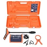
- PROFESSIONAL-GRADE UTILITY LOCATOR – Locate underground electrical lines, telecom cables, irrigation wires, and metallic pipes with precision over 1 mile (1.6 km) and depths up to 20 feet (6 m) with the 551 underground wire locator.
- DUAL FREQUENCIES + INTELLITRACK NOISE REJECTION – Simultaneously transmit two frequencies and eliminate AC interference with proprietary IntelliTrack digital filtering for accurate readings in noisy environments with the 551 cable locator.
- PEAK & NULL RECEIVER MODES – Choose between peak or null response to fine-tune your search and detect anomalies with confidence, even in complex underground environments with 551 buried wire locator.
- FLEXIBLE CONNECTION OPTIONS – Use direct wire connection , inductive clamp, or built-in antenna on 551 wire locator for maximum adaptability on active or inactive systems.
- BUILT FOR THE FIELD – Rugged, IP54-rated, and ergonomically designed with a lightweight receiver and durable case for reliable use in demanding job sites.
- Street address, parcel number if posted, and nearest cross streets.
- Project name, developer, contractor, and sponsoring public agency.
- Permit, case, subdivision, site-plan, or notice number.
- Observed work, such as excavation, utility trenching, grading, dewatering, demolition, or paving.
- Dates and hours when work or runoff was observed.
Search the city or county planning commission, building department, public works department, and utility project pages for the address and project name. Meeting agendas, zoning cases, subdivision approvals, road-improvement programs, and public-notice pages often contain the first references to utility relocations or drainage changes. If the online record is incomplete, ask the local clerk or records office how to request the project file and whether inspection reports or approved plan sets are available for public review.
Step 2: Ask for records that answer your specific concern
For drinking-water questions
Ask the water provider whether the project is near or working on a water main, service connection, reservoir, wellhead, source-water protection area, treatment plant, or distribution facility. Request confirmation of:
- Any planned shutdown, flushing, pressure change, boil-water notice, or temporary source change.
- Whether the contractor must submit a connection, disinfection, sampling, or abandonment plan.
- Which streets or customers would receive advance notice if service is interrupted.
- Who to call if water becomes discolored, loses pressure, or develops an unusual odor.
These are questions for the utility, not effects you should assume from the project’s location. A private well may be outside the public utility’s records, so ask the local health or environmental office about well-protection requirements as well.
Quick wins for a faster PC:
Fix the driver behind crashes, sound loss and screen glitchesFind Drivers →Repair Windows errors before they cause bigger problemsFix Now →Scan for outdated or missing drivers - takes under a minuteDriver Scan →For sewer questions
Contact the sanitary-sewer operator and ask whether the work touches a sewer main, force main, pump station, manhole, or private service lateral. Ask for the approved method for:
- Temporary bypass pumping and where bypass flows will go.
- Trench dewatering and discharge treatment.
- New connections, testing, plugging, or abandonment of old lines.
- Responding to a sewage backup, gurgling, odor, or manhole overflow during construction.
Federal compliance databases can identify wastewater facilities, but they do not map every neighborhood pipe or prove that a local backup came from a particular project. The sewer operator needs to compare your address, the project plans, and the system’s maintenance records.
Rank #2

- Extended trace range over the Leica DD120 with additional low frequencies (512Hz and 640Hz)
- Kit includes DD130 Locator, DA175 1 Watt Signal transmitter, and carry bag which offers a turn key Package for locating underground utilities
- Safely locate underground power, water, gas, and Cable lines
- Automatic pinpointing at depths up to 33 feet (With Sonde - not included) with power, radio, auto modes
- Health check and start up test each time you turn on the unit to ensure proper functionality
For drainage and flooding questions
Request the approved site, grading, drainage, erosion-and-sediment-control, and stormwater plans. Ask the stormwater or public-works authority:
- Where runoff from the site goes today and where the plan sends it during each construction phase.
- Which storm drains, ditches, culverts, detention facilities, streams, or outfalls receive flow.
- What controls protect inlets and slopes during clearing, excavation, and paving.
- Whether the project has a construction stormwater permit and a stormwater pollution prevention plan (SWPPP), and how those documents can be inspected or requested.
- Who investigates blocked inlets, sediment leaving the site, unauthorized discharges, or flooding.
EPA describes the mechanism this way: “As stormwater flows over the site, it can pick up pollutants like sediment, debris, and chemicals from that loose soil and transport them to nearby storm sewer systems or directly into rivers, lakes, or coastal waters.” That explains why runoff deserves prompt reporting, but it does not identify responsibility for a specific event.
Step 3: Determine which agency has authority
Do not assume that EPA issued the project’s permit. Under the National Pollutant Discharge Elimination System (NPDES), EPA administers permits in some jurisdictions, while authorized states administer them in many others. Certain federal and Tribal contexts also have separate permitting arrangements. The project’s location determines the issuing authority.
Use the local planning or building office to locate land-use and construction approvals, the water or sewer utility for service and buried assets, and the stormwater or environmental office for runoff complaints. If the local office refers you to a state environmental agency, ask for the permit number, inspection contact, and public-notice page. Keep the referral so you know which office is responsible for follow-up.
Federal construction-stormwater rules to use as context
EPA’s current construction-stormwater guidance says a Clean Water Act permit generally is required for stormwater discharges from construction that disturb one acre or more. A smaller site can also be covered when it is part of a common development plan that will ultimately disturb at least one acre. The one-acre figure is a federal permitting threshold, not a measurement of how likely your home is to be affected. State, county, and municipal rules may apply at smaller sizes or impose additional controls.
Rank #3

- ACCURATE UNDERGROUND WIRE LOCATOR. Quickly isolate, trace the path and determine the depth of buried conductors (wires or metallic pipes) over distances of 4,000 feet (1.2 km) and depths of 7 feet (2.2 m) with the 501 underground wire locator.
- EASILY LOCATE AND TRACE Electrical lines, Communications cables, Electric dog fence cables, Fish tape and Metallic pipes, Invisible fence wires, Outdoor or Landscape lighting cables with 501 buried wire locator. Trace Electric, Power, Coax, Telephone, and Utility lines with the 501 underground wire locator.
- EFFICIENT: Save yourself hours to trace buried cables, wires, or pipes. With inductive signal detection, this cable and buried wire locator can be used on active or dead systems, making it quick and easy to trace the path and determine the depth of buried wires and trace metallic pipes.
- COMPLETE PORTABLE KIT: 501 buried wire locator comes with a transmitter assembly, receiver assembly, inductive coupler (clamp), built-in inductive antenna, two 8-foot (2.4 m) test leads with heavy-duty alligator clips, and a durable polyethylene case, making it a complete package for all your location needs.
- CONNECTION OPTIONS: Options for direct connection, inductive clamp, and inductive antenna allow active or dead systems location. Transmitter output and receiver sensitivity are fully adjustable for maximum accuracy.
The federal requirements described by EPA include effective erosion and sediment controls, pollution-prevention measures, stabilization of idle disturbed areas when work will not resume for more than 14 days, managed dewatering, and restrictions on uncontrolled concrete washout, fuels and oils, and wash water. A permit or SWPPP shows what the operator promised to do; it does not guarantee that every field condition complies. Compare the approved controls with what you observe and report discrepancies.
What’s actually slowing this PC down?
Pick the symptom - the matching free tool is one click away.
Permit status is subject to change. EPA reported that a proposed 2027 Construction General Permit was published on August 3, 2026, with the comment deadline extended to September 17, 2026. The existing 2022 Construction General Permit is scheduled to expire on February 16, 2027. Those dates describe federal permit administration and do not determine which permit governs an individual project or whether a state-issued permit uses the same schedule. Confirm the current requirement with the project’s permitting authority.
Use federal tools for context, not as an impact determination
| Tool or record | Useful question | Important limitation |
|---|---|---|
| EPA Public Water System Service Areas map | Which public water provider is likely to serve the property? | Boundaries include modeled areas and some systems may be missing. EPA says local government is typically the most accurate source for a particular address; private wells and unmapped systems may not appear. |
| EPA DWMAPS | What drinking-water providers and potential contamination sources are in the broader source-water setting? | It does not display actual public-system intake locations and cannot show whether this project reaches your service line. |
| EPA ECHO | Are there regulated drinking-water, wastewater, or stormwater facilities and what compliance records are available? | A facility result is a lead for follow-up, not evidence that nearby construction caused a symptom. |
| NPDES permit maps and public notices | Which authority issued or noticed a construction-stormwater permit? | Maps and notices do not replace the approved local grading, utility, and drainage plans. |
EPA’s service-area page, last updated August 10, 2026, reports more than 44,000 community systems covering roughly 99% of the reported population served by community systems. That statistic describes the map dataset’s coverage, not the certainty of service at an individual address. Use the map to find a likely provider, then verify your connection with the local government or utility.
Compare the approved plans with what is happening on site
Organize your review around five comparisons:
- Asset: Is the concern about drinking-water distribution, sanitary sewer, or stormwater? A storm drain is not a drinking-water pipe, and a wastewater facility record does not reveal every local sewer lateral.
- Phase: Is the effect temporary during clearing, trenching, dewatering, or utility tie-in, or could the finished project permanently redirect runoff?
- Pathway: Is there direct utility work, or is the suspected route runoff over disturbed soil? Treat those as separate hypotheses.
- Plan versus field: Do inlet protections, sediment barriers, detention areas, outfalls, and utility alignments match the approved drawings?
- Authority: Which office can inspect or order a correction—the utility, municipal or county department, state environmental agency, or EPA?
Mark your address and the project on a local map, then trace the actual pipe, ditch, drainage basin, or outfall shown in the plans. “Nearby” is not a technical connection. A project may be physically close yet drain to another basin or connect to a separate water main; conversely, a project farther away may share a downstream outfall or pressure zone.
Document symptoms and report them promptly
If you observe a problem, create a contemporaneous record rather than relying on memory. Include:
Free tools Windows power users keep installed
One-click scans. No signup required.
Rank #4

- COMPACT SONDE AND LINE LOCATOR: Perfect for SeeSnake cameras, remote transmitters, or flushable sondes; targets pipes, cables, and energized lines; use with SeeSnake inspection reels or other sondes
- MULTI-DIRECTIONAL TECHNOLOGY: The antenna detects signals from all directions, maximizing signal strength and eliminating false peaks or nulls, ensuring accurate target location
- ENHANCED DETECTION CAPABILITIES: Features 4 Sonde and 5 Line trace mode frequencies; the digital readout delivers real-time signal strength with no false peaks, ensuring fast, accurate locates
- PRECISE TARGETING: Micro-mapping verifies locate positions with on-screen markers for poles in front of and behind your target; depth calculations automatically display when directly over the target
- ALL-IN-ONE PACKAGE: Includes a carrying case for easy transport and protection, plus surface marker chips, an instructional video, an operator’s manual, and 4 C-cell batteries
- Date and time, exact location, and weather or recent rainfall.
- What changed: muddy runoff, material entering a drain, water discoloration, pressure loss, odor, sewage backup, overflowing manhole, standing water, or new flooding.
- Photos or video from a safe location, with a wider image showing the road, drain, creek, or project boundary.
- The project name, address, contractor, and permit number if known.
- Who you contacted, when, what you reported, and the response or reference number.
Report water-service symptoms to the water provider, sewer symptoms to the sewer operator, and runoff or flooding to the local stormwater, public-works, or environmental-enforcement office. Send the same concise timeline to the permitting authority if the issue involves a permit condition. Use emergency services for immediate hazards such as an exposed utility, dangerous flooding, electrical risk, chemical release, or an unsafe roadway.
Do not enter a work zone, open a manhole, sample an unknown discharge, or confront workers. Keep children and pets away from pooled water that may contain sewage, sediment, or construction chemicals. A water test can identify selected properties, but it cannot by itself establish that construction caused the result; the utility or environmental agency must interpret it with system records and sampling controls.
Independent reader supportYour contribution helps us test, update, and keep practical guides available for everyone.How to interpret common findings
The project has no utility connection near your property
If the utility confirms separate mains, service areas, and drainage routes, a direct effect on your buried service is less likely. Continue to report observed runoff or flooding because a downstream outfall or altered grade can still matter even without a direct connection.
The plans show a connection, relocation, or shutdown
Ask for the work date, affected addresses, notice procedure, flushing or disinfection steps, and after-work verification. For sewer work, request the bypass and dewatering contact. Keep the utility’s written response with your project file.
Runoff controls are shown but missing or failing
Photograph the condition without entering the site and report it to the stormwater authority and permit contact. Note whether controls failed after rainfall, whether sediment reached a drain or waterbody, and whether the discharge is continuing. Agencies can decide whether an inspection, corrective action, or sampling is warranted.
Best Value

- Easy to Use
- Left / Right Arrows Guide You To Buried Utility
- Single Frequency Locator
- 1W Transmitter
- 1 Year Warranty
You cannot find a permit or project file
Ask the city or county records office to search by parcel, address, developer, and public-agency sponsor, not only by the sign’s project name. Ask whether the work is covered by a state general permit, a municipal separate storm-sewer-system program, a road or utility authorization, or an exemption. Absence from one online database is not proof that no authorization exists.
A practical contact script
When you call or write, provide the address and ask one agency-specific question at a time:
- Planning or building office: “Please identify the approved site, grading, drainage, and utility plans for [project address], and tell me how to request the permit file and inspection records.”
- Water utility: “Does this project connect to, cross, relocate, or operate near the water facilities serving [your address]? Are any shutdown, flushing, pressure, or boil-water notices planned?”
- Sewer utility: “Does the work affect a sewer main, force main, pump station, manhole, or service lateral? What is the bypass, dewatering, and backup-reporting procedure?”
- Stormwater or environmental office: “Where does this site discharge during construction and after completion? Is there a construction-stormwater permit or SWPPP, and where should I report sediment, blocked inlets, or flooding?”
Request a written reply when possible. Written answers reduce misunderstandings about which agency is responsible and give you a reference number for later follow-up.
What you can conclude—and what you cannot
You can establish whether the project has identified utility work, which agency issued the relevant approval, where runoff is designed to go, and whether observed conditions match the approved controls. You generally cannot establish causation from distance, a single photograph, a map search, or a one-time home water test. No published statistic in the cited federal materials estimates the chance that an unspecified nearby project will affect a particular home’s water, sewer, or drainage, so do not convert the one-acre permit threshold or map coverage percentage into a household-risk probability.
The most reliable path is a documented chain: identify the project, obtain the plans and permits, verify the responsible utility, compare the plans with field observations, and report specific symptoms through the correct channel. That process distinguishes a real service or drainage connection from a coincidence and gives the agencies enough detail to investigate.
Quick Recap
Product prices and availability are accurate as of the date/time indicated and are subject to change. Any price and availability information displayed on Amazon at the time of purchase will apply.

