Choose a check-dam site only after confirming that a small, concentrated-flow channel, its drainage area, and its expected storm flows fit the governing local standard. The best location has a surveyed slope that permits practical spacing, a stable bed and banks that can be keyed into, and a protected center overflow path that will not flood upstream or scour the channel below.
Use slope, flow, soil and regulatory checks together. A handheld inclinometer can support a preliminary screen, but it cannot replace a survey, hydrologic and hydraulic analysis, or professional design.
As an Amazon Associate I earn from qualifying purchases.
What a suitable check-dam site looks like
A check dam is a small structure placed across a swale, ditch or other concentrated-flow channel to reduce water velocity and limit channel erosion. It is not automatically appropriate for every drainage feature. Begin with the channel and drainage area, then test whether the proposed location can pass high flows safely and hold the structure in place.
What’s actually slowing this PC down?
Pick the symptom - the matching free tool is one click away.
The U.S. Environmental Protection Agency’s December 2021 Stormwater Best Management Practice: Check Dams fact sheet gives examples of channels draining 10 acres or less where velocity exceeds 4 feet per second during a 2-year, 24-hour storm. The California Department of Transportation’s SC-4 guidance describes small open channels draining 10 acres or less and steep channels with velocities above 5 feet per second. These are agency-specific examples, not a universal eligibility rule. Your state, municipality, watershed authority or project permit may use different limits.
#1 Best Overall

- VERSATILE DIGITAL ANGLE GAUGE AND LEVEL: Measure angles, check relative angles with zero calibration feature, or use as a digital level with ease
- HIGH VISIBILITY AND AUTO-ROTATING DISPLAY: Reverse contrast display improves visibility in low light conditions and automatically rotates when upside-down for easy viewing
- STRONG MAGNETIC BASE: Attach to ferromagnetic surfaces like pipe, electrical conduit, miter saw blades for woodworking, vents, ducts, and more for convenient hands-free operation
- V-GROOVE EDGES: Ensure optimal alignment on conduits and pipes for bending and alignment tasks
- WIDE MEASUREMENT RANGE: Measure between 0-90, or 0-180 degrees - useful when accounting for springback when bending conduit
Check dams are most defensible where a channel is not yet vegetated or where a permanent lining is infeasible. An established vegetated channel can be damaged by ponding, construction traffic or loss of its existing flow pattern. A live stream or other regulated waterway requires authorization before installation; do not treat a ditch that connects to a stream as an unregulated construction feature.
Screen the drainage area and channel before measuring details
Confirm the contributing area
Draw the drainage boundary that sends runoff to the candidate cross-section. Include upstream roofs, roads, lots, disturbed ground, culverts and neighboring swales that can combine during a storm. Record the area in the units used by the local standard. A small area on a plan can produce a concentrated, fast flow if the contributing surface is steep or heavily impervious.
Identify the channel type
Document whether the feature is a temporary construction swale, roadside ditch, agricultural drain or natural channel. Note its ordinary flow, evidence of previous high-water marks, bank undercutting, existing lining and connection to downstream waterways. A check dam intended for construction runoff should not be assumed suitable as a permanent grade-control structure.
Recommended Free Tools
Check vegetation and existing uses
Map established grass, shrubs, trees, wetlands, utilities, access roads and adjacent structures. Ponding behind a dam can drown vegetation and can redirect water toward a foundation, roadway or property boundary. Construction access must allow installation, inspection and eventual removal or repair without destabilizing the banks.
Use the longitudinal slope to determine whether spacing is feasible
Survey the profile, not just one slope reading
Take elevations along the channel centerline at each likely dam, at abrupt grade changes, at culvert inlets and outlets, and at the downstream discharge point. A single inclinometer reading describes only a short segment; it cannot reveal a convex or concave profile that changes the backwater pattern. Tie the profile to a known benchmark or a consistent project datum so candidate locations can be compared.
Calculate the grade for each reach as the elevation change divided by horizontal distance, and record the direction of flow. Also measure cross-sections wide enough to show bank tops, the ordinary bed and any low points where water could bypass the structure. Keep the field notes, stationing and photographs with the design record.
Lay out a series by elevation
For a series of dams, place each downstream crest at approximately the same elevation as the toe of the dam immediately upstream. This creates a stepped water-surface profile rather than isolated barriers. Verify the relationship with the surveyed elevations and the backwater calculation required by the applicable manual; visual alignment alone is unreliable.
Do these 3 things before closing this tab:
1Scan for outdated or missing drivers - takes under a minute2Clear out junk files and repair common Windows errors3Fix the driver behind crashes, sound loss and screen glitchesRank #2
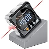
- Nivel Digital Level with Laser - (Class II laser, Output<5mW) L2.4in, W2.4in, H1.2in, portable pocket size with matching belt bag. ±0.2° precise microprocessor with automatic inversion when upside down. 4*90° measurement can be used at many angles and can be zeroed at any angle for comparison.
- Craftsman's Choice - Not only the baseboard, but also the strong magnetic upgrade at the four sides. Never slide on the table saw blade or any metal surface. Magnetic feature and lasers are great advantages for measuring, cutting, leveling in woodworking renovations and building furniture.
- Save time and effort hanging decorations - Dual lasers are great helper for horizontal and symmetrical installation. Furthermore, this digital leveler tool maybe a great gift for father's day, birthdays, Christmas.
- This inclinometer, digital angle finder comes complete with a USB-C charging cable for the internal 340mAH rechargeable battery. It also has dust-proof and IP67 waterproof performance with bright red backlight. Even in garage, with the door open and the sunshine pouring in, you can easily read the display.
- Technical Parameters - Material: aluminum alloy| Measuring range: 4*90°| Resolution: 0.05°| Accuracy: ±0.2°| Repeatability: 0.1°| Power supply: 3.7V lithium battery| Working temperature: 14-122℉
Recognize when the grade is too steep for practical spacing
Steeper or more erosion-prone swales require closer spacing. Idaho Transportation Department SC-2 guidance notes that on slopes typically greater than 3H:1V, dams may need to be so close together that a slope drain should be considered instead. This is a caution about constructability and performance, not a universal prohibition at one numerical slope. If the required intervals would leave no room for safe overflow, inspection or maintenance, compare an approved slope drain or another grade-control practice with the local engineer.
Evaluate flow, overflow and downstream consequences
Define the design event and expected velocity
Identify the storm event required by the permit or design standard and estimate peak discharge and velocity at the proposed cross-section. The EPA and Caltrans examples use different velocity thresholds and contexts, so do not merge them into one rule. A qualified designer may need watershed calculations, a hydraulic model or a field measurement campaign, especially where the channel receives runoff from multiple surfaces.
Make the center the intended overflow path
The crest should direct high flows over its center rather than around an end. Check that the crest elevation, width and downstream protection are sized for the expected flow under the governing standard. A dam that blocks the center and leaves a low bank at one side invites an end-around jet that can rapidly cut the bank.
Check upstream capacity and flooding
Because a dam raises the local water surface and reduces channel capacity, calculate or otherwise verify the upstream water level for the design event. Look for driveways, building pads, utility crossings, culvert entrances and property lines that could be flooded by the added ponding. A location is unsuitable if safe overflow depends on water entering an area that cannot tolerate it.
Protect the downstream bed and banks
Flow passing over a dam becomes turbulent and can scour immediately below it. Inspect the bed material and grade at the proposed outfall, and provide the downstream protection required by the local standard. Extend the review far enough downstream to find where the jet could strike a bank, culvert or unprotected bend. A dam that slows water locally but transfers erosion to the next reach has not solved the problem.
Check for bypass and emergency routes
Walk both banks during and after rainfall when safe. Identify low saddles, animal paths, tire ruts, roots and cracks that could become a bypass channel. Confirm that an exceedance flow has a stable route and cannot cut around the structure, overtop a bank or erode a neighboring property.
Verify soil, bed and bank stability
Inspect the foundation zone
Expose or probe the proposed bed and bank contact areas enough to identify loose fill, soft organic material, voids, buried debris, piping, groundwater seepage and seasonal saturation. The structure must be keyed into the sides and bottom so water cannot travel beneath or around it. A foundation that looks firm when dry can weaken when saturated.
Rank #3

- FOUR SIDES STRONG MAGNETIC — Digital laser level has strong magnets on four sides that firmly adsorb on the measuring object, ensuring accuracy and not easily falling off. Three easily operated buttons can activate the built-in red laser line on both sides, hold the measured value, switch the unit of the measured value and zeroing function to realize relative measurement.
- THREE IN ONE — This tool has the functions of digital level, angle finder and laser lines(Class II, Output<5mW). Visible measurement value avoids staring at the bubbles in the traditional tube and quickly obtains the level status. Two built-in laser liners are convenient and effective to carry out the horizontal and symmetrical work of home decoration. The zero button can effectively realize absolute or relative angle measurement.
- PROVIDE ACCURACY & CONVENIENT — 360°/4×90° measure angle, the measured value on the display is automatically adjusted. The hold button can memorize the measured values is convenient for taking measurements in narrow spaces, inverted situations, and curved pipes. Display value flipped automatically when mounted upside down, with ±0.2° accuracy and 0.05° resolution to ensure accurate measurement every time.
- BACKLIGHT LCD DISPLAY — Digital angle finder with an easy-to-read display for clear measurement results in any lighting conditions. IP54. The palm-sized, compact design of the angle gauge is easy to carry with a black belt loop storage bag, no matter whether indoors or outdoors is convenient to use. 400mAh, rechargeable, ultra-long standby time, the power display for easy charging in time.
- PORTABLE & RELIABLE- Lightweight and heavy-duty digital angle finder tool is easy to carry and use, meets most woodworking, operation, home maintenance and decoration needs. Also a great gift for men at festivals. Coobeast tools have quality assurance, feel free to contact us if there are any problems with the product. We provide you with service for the first time.
Assess bank geometry and erosion
Record bank height, side slope, cracks, sloughing, roots and evidence of previous overtopping. A narrow, collapsing bank may not provide enough embedment for the ends. If the banks are already eroding, stabilize the channel or relocate the crossing before placing a dam.
Do not rely on a soil label alone
Clay, silt, sand, gravel and fill behave differently when wet, but the cited EPA, Caltrans and Idaho manuals do not establish one universally suitable soil class or a single soil-strength cutoff. Soil type is one input to spacing and foundation design, not a pass/fail answer by itself. Where the structure is permanent, near a road or building, or founded on fill, obtain the geotechnical or civil review required by the project.
A field procedure for screening candidate locations
- Map the catchment. Delineate the drainage area, identify upstream diversions and estimate where concentrated flow begins.
- Classify the channel. Record whether it is a swale, ditch or natural channel; note vegetation, ordinary flow, lining and downstream waterway connections.
- Confirm authorization. Check the current construction BMP, stormwater permit, floodplain rules and waterway permits before disturbing the bed or banks.
- Survey the profile and sections. Measure centerline elevations, bank tops, bed width, low points, culverts and grade breaks. Use repeat readings to catch instrument errors.
- Estimate the design flow. Use the event and method required by the local standard. Document the drainage area, assumed runoff conditions, peak flow and velocity or the reason a professional calculation is required.
- Mark potential crests. Place trial locations where the banks are stable and access is possible. Check that each downstream crest can align approximately with the upstream toe elevation.
- Test spacing and ponding. Sketch or model the backwater between locations. Reject intervals that require impractical construction, inundate a road or property, or leave no inspection access.
- Check overflow and bypass. Trace the center overflow path, both ends and the downstream receiving reach for scour, flooding and weak points.
- Review soil and embedment. Confirm that the bed and banks can accept the required key and that seepage, piping or soft layers will not undermine the structure.
- Document the decision. Keep the survey, photographs, assumptions, calculations, permit determination and maintenance plan. Obtain design approval before construction.
Compare candidate sites with the same criteria
Use one worksheet for every location so a visually attractive site does not win simply because it was inspected first.
| Comparison factor | Record | Favorable indication | Warning or required action |
|---|---|---|---|
| Drainage area and channel | Area, channel type, upstream surfaces and waterway connections | Concentrated flow within the applicable local practice | Area or channel falls outside the standard; obtain a different design |
| Longitudinal slope | Profile, grade breaks and cross-section elevations | Spacing can follow the required crest-to-toe relationship | Intervals become too close to build or maintain; compare a slope drain or other approved control |
| Design flow | Storm event, peak discharge and velocity | Center overflow can pass the design event without upstream flooding | Uncertain hydrology, excessive velocity or inadequate capacity; require hydraulic review |
| Bed and banks | Material, saturation, cracks, undercutting and embedment depth | Stable foundation and enough bank width for keyed ends | Soft fill, piping, active erosion or bypass risk; improve the foundation or relocate |
| Downstream reach | Bed grade, bends, culverts and scour-sensitive features | Stable receiving reach with approved outlet protection | Turbulence would strike an unprotected bed, bank or structure |
| Vegetation and property | Existing plants, wetlands, roads, utilities and buildings | Temporary ponding and access do not damage protected features | Established vegetation would be harmed or ponding would flood an asset |
| Construction and maintenance access | Equipment route, inspection points and removal plan | Safe access in wet and dry conditions | Access would require destabilizing a bank or entering a regulated area |
| Permitting | Applicable agency, permit and inspection requirements | Written authorization and standard details are available | Live-stream or waterway work lacks approval; stop and obtain it |
Translate a promising screen into a preliminary layout
Once a location passes the screen, lay out the series from the downstream control point upstream. Set each crest and toe from the surveyed elevations, then verify the water-surface profile for the required flow. Do not simply divide the channel length by an arbitrary number of dams; slope, roughness, soil and discharge determine the workable interval.
Detail the center crest as the controlled overflow route and key both ends into competent banks. Seal the bed contact against underflow using the approved material and embedment specified by the project standard. Provide downstream energy dissipation or lining where the standard requires it. The design should show cross-sections, profile, elevations, materials, embedment, access, inspection points and the removal or conversion plan.
Quick wins for a faster PC:
Scan for outdated or missing drivers - takes under a minuteDriver Scan →Repair Windows errors before they cause bigger problemsFix Now →“Check dam dimensions depend on slope and expected flow velocities.” — U.S. Environmental Protection Agency, 2021 fact sheet
That statement is a design boundary: dimensions cannot be selected from a generic sketch without the site slope and flow inputs. Where calculations indicate that a check dam would reduce capacity or create unsafe turbulence, select another approved practice instead.
Rank #4

- Ultra Small Digital Level Box - Measuring only 35mm in length and width, 20mm in thickness, it's as compact as a half-dollar coin. Carry this convenient tool in your pocket or hang it on your keychain for optimal accessibility. Ideal for magnetic angle finder applications.
- Experience the powerful magnetic convenience of this digital level box. The button side contains powerful magnets, ensuring stable fixing to any metal surface. Perfect for table saw blade angle gauge and other woodworking tasks.
- Enjoy the Clear & Bright Display with backlit feature, providing better visibility in any lighting condition. Whether you're working indoors or outdoors, our digital leveler delivers remarkable precision.
- Embrace the innovative rechargeable technology of our sophisticated digital level box. With a 230mAh Long-Lasting battery and Automatic shutdown after 3 minutes of non-use, this hgh-class tool ensures uninterrupted performance. Convenient Type-C charging adds to its unparalleled convenience. Perfect for woodworkers and professionals seeking a top-tier level.
- With an accuracy of ± 0.2°, it delivers pristine measurements for your projects. Its unique IP67 Water Proof and Dust Proof design ensures reliable performance even in challenging environments. A Prestigious tool for machinists and those in search of unparalleled precision.
Know the common failure modes before approving a site
Water goes around an end
Cause: The bank is low, the end was not keyed in, or the crest is lower at one side. Response: Recheck cross-section elevations, extend the key into stable material and restore the intended center overflow. If the bank cannot provide embedment, relocate the structure.
Water cuts beneath the structure
Cause: Loose or saturated bed material, inadequate embedment or seepage paths. Response: Investigate the foundation, remove unsuitable material where authorized and install the approved cutoff or key. A surface patch will not correct internal piping.
Free tools Windows power users keep installed
One-click scans. No signup required.
Upstream flooding increases
Cause: The dam reduces channel capacity or is spaced too closely for the design event. Response: Recalculate the backwater, lower or relocate the control only under the engineer’s direction, and protect nearby roads, buildings and utilities.
Downstream scour worsens
Cause: Turbulent overflow discharges onto an unprotected bed, bank or bend. Response: Provide the specified outlet protection, lengthen the stable receiving reach or choose a different grade-control method.
Vegetation dies behind the dam
Cause: Prolonged ponding, buried stems or construction disturbance. Response: Avoid established vegetated channels where possible and remove or modify the temporary control when the construction phase ends, subject to permit conditions.
Situations that call for another practice
- The feature is a live stream or regulated waterway and approval has not been obtained.
- The channel is already stable and vegetated, while ponding would damage that vegetation or adjacent assets.
- The required spacing on a steep slope is so close that dams would be difficult to build, inspect or maintain; an approved slope drain may be more appropriate.
- Hydrology or hydraulic capacity is uncertain and no qualified designer is available to verify safe overflow.
- Banks cannot provide a stable key, or the bed is subject to piping, undermining or persistent groundwater seepage.
- The downstream reach cannot accept turbulent discharge without unacceptable scour.
Use an inclinometer as a screening aid, not a design substitute
A handheld digital inclinometer can quickly identify grade changes and compare candidate reaches. Calibrate it according to the manufacturer’s procedure, hold it consistently on a straightedge or survey rod, and take readings in both flow directions. Repeat each reading and note the measurement length, surface condition and weather.
Use the readings to decide where a survey crew should establish profile points. Do not use an inclinometer reading alone to set dam elevations, calculate design discharge, certify a permit drawing or approve construction. The device does not measure drainage area, storm flow, soil strength, backwater or downstream scour.
Best Value

- High Precision Measurement for Accurate Results: This digital angle finder delivers ultra-accurate readings with full coverage of 4×90°, allowing easy measurement of absolute or relative angles and inclinations in any situation. With an accuracy of ±0.2°, it’s perfect for precise tasks in woodworking, construction, and table saw operations, ensuring reliable results every time.
- LED Display: Equipped with a large, clear LED display, this angle gauge provides real-time data visibility even in daylight. This feature improves work efficiency for both indoor and outdoor tasks, eliminating struggles with hard-to-read measurements under varying light conditions.
- Powerful Magnetic Base: Magnetic design on all four sides for a solid attachment to metal surfaces - allows totally hands-free use and multi-angle alignment without slipping or moving.
- USB Rechargeable and Auto Shut-Off: Built-in rechargeable battery with USB charging capability ensures easy power replenishment on-site. It includes a data hold function and auto-shutoff after 3 minutes, extending battery life and facilitating continuous use during long work sessions, reducing the hassle of frequent battery replacements.
- Strong and Easy to Use Design: rugged outer shell resistant to impact and daily wear - simple operation with intuitive buttons: short press to turn on, long press to turn off, and ZERO button to reset the Angle.
Apply the governing standard and local approvals
EPA’s 2021 check-dam fact sheet, Caltrans SC-4 and Idaho Transportation Department SC-2 illustrate how agencies address applicability, spacing and installation, but they are not interchangeable. Confirm which edition is adopted for your project and whether a municipal detail overrides a state manual. Requirements may differ for public roads, private construction, agricultural drains and permanent waterways.
Before work begins, ask the authority having jurisdiction whether the channel is a regulated water, whether a stormwater permit covers the activity, and whether notification, inspection or post-construction removal is required. EPA specifically advises against installing check dams in streams or other waterways without approval from the appropriate regulatory agency.
Why watershed maps cannot replace a site investigation
Geospatial suitability studies can help prioritize reconnaissance, but their percentages are local. A 2021 study of the Debre Berhan region of Ethiopia classified 16.6% of its mapped area as poor suitability, 41.63% as low, 29.61% as moderate, 8.88% as high and 3.28% as very high. The authors characterized that study area as having low-to-moderate suitability for storage locations. Those values describe that watershed’s data and criteria; they cannot be applied to a different state, country or project.
Windows Errors? Fix Them Before They Spread
Repair common Windows errors and clear accumulated junk for a smoother, more stable PC - no reinstall needed.Free scan · no reinstallCrashes, No Sound, or Screen Glitches?
Random freezes, missing sound and display glitches usually trace back to one bad driver. Find and replace yours safely.Free scan · under a minuteUse maps to locate possible channels, then verify slope, flow, soil, access and regulation in the field. Local conditions and the current governing standard take precedence over a regional suitability class.
Plan inspection and maintenance from the start
Assign responsibility for checking the series after installation and after the design storm specified by the permit. Inspect the crest, center overflow, keyed ends, bed contact, upstream ponding and downstream scour. Look for fresh rills, exposed edges, settlement, clogged flow paths, debris accumulation and bank cracking.
Remove debris only when it can be done without entering unsafe water or weakening the structure. Repair damage with the approved detail, not by piling loose material against an eroded end. Record inspection dates, rainfall or storm triggers, observed water levels and corrective work. Keep checking until the disturbed drainage area is stabilized and the temporary controls can be removed or formally converted under the project’s approved plan.
Decision rule
Proceed only when all four core tests are positive: the channel and drainage area fit the applicable standard; the surveyed slope allows practical crest-to-toe spacing; the design flow has a stable center overflow with no unacceptable upstream flooding or downstream scour; and the bed and banks can support a keyed structure. If any test fails or remains unknown, pause construction and obtain the survey, hydraulic, geotechnical or regulatory review needed to resolve it.
Quick Recap
Product prices and availability are accurate as of the date/time indicated and are subject to change. Any price and availability information displayed on Amazon at the time of purchase will apply.

