Recommended Free Tools
You usually do not need full BIM for a small renovation. Start with the least complex workflow that controls the project’s measurable risks: a disciplined, measured 2D CAD set for straightforward room alterations; a registered point cloud plus CAD when existing geometry or records are unreliable; selective 3D when clearances and coordination justify it; and full BIM only when multi-discipline coordination, quantities, phasing, asset data, handover, or an authority requirement makes a model contractually useful.
The right choice is not “CAD versus BIM” in the abstract. It is the cheapest dependable record of existing conditions and proposed work, with enough information to prevent wrong dimensions, clashes, rework, and approval problems.
As an Amazon Associate I earn from qualifying purchases.
What “alternative to BIM” means on a small renovation
Building information modeling is a data-rich, object-based workflow. A wall can carry geometry, materials, fire ratings, quantities, and other properties that remain connected as the design changes. That capability is valuable, but creating and maintaining it has a cost in survey work, software, staff skill, coordination, and quality control.
The Tool Desk
Outbyte PC Repair FREERepair Windows errors before they cause bigger problemsFix Now →Outbyte Driver Updater FREEScan for outdated or missing drivers - takes under a minuteDriver Scan →For an existing building, the first question is not whether the project can be modeled. It is whether the model will reduce a risk that matters on this job. A measured drawing may be the best answer for a small bathroom alteration with reliable dimensions. A point cloud may be more valuable than a detailed model when the building is old, crooked, or poorly documented. A selective 3D model can resolve a tight stair, roof connection, or services zone without turning every existing surface into a classified BIM object.
#1 Best Overall

- 【Industrial-Grade Accuracy】Achieve single-frame accuracy up to 0.03 mm and volumetric accuracy of 0.03 mm + 0.05 mm x L(m), faithfully reproducing the finest surface details and complex geometries with exceptional consistency. Full-Field Structured Light accuracy reaches 0.08 mm; VCSEL mode delivers 0.10 mm @ 300-500 mm and 0.20 mm @ 500-800 mm. Engineered to meet the demanding requirements of 3D printing, reverse engineering, and precision modeling applications.
- 【Ultra-Fast Scanning & Robust Frame Rate】Multi-line Laser mode delivers up to 105 fps with NVIDIA GPU acceleration. Full-Field Structured Light mode achieves up to 5,000,000 points/s. The high frame rate ensures a smooth, uninterrupted scanning experience, especially suited for rapidly capturing large objects and complex scenes, significantly boosting overall workflow efficiency.
- 【AI-Powered & Photo-Grade Retopology】 AI object segmentation (Windows only) identifies your target in one click, tracks it throughout the scan, and auto-filters background noise — delivering clean data and streamlining post-processing. The patented 3D Gaussian Splatting converts point cloud and RGB data into true-to-life 1:1 photorealistic models; import photos from your phone or camera to apply real textures, then export in splat format for gaming, animation, and VR.
- 【All-Weather Outdoor Scanning】Multi-line Laser mode operates reliably up to 50,000 lux; with an outdoor filter attached, scanning remains stable in lighting conditions of up to 100,000 lux; VCSEL mode operates reliably in up to 100,000 lux ambient light. Designed to overcome lighting challenges, it provides consistent all-weather performance for construction sites, archaeological digs, and industrial fieldwork.
- 【5 Scanning Modes】NIR band supports Full-Field HD Scanning (markerless, fine structured light), Hybrid HD Scanning (dual projectors, fast high-quality modeling), and VCSEL Rapid Scanning (high-density pattern, fast markerless capture). Blue light band supports 30-Cross Laser Lines Scanning (handles high-reflectivity metals & dark objects) and Single-Line Deep Hole Scanning (captures from deep holes & narrow grooves). Five modes for comprehensive indoor and outdoor coverage.
Ohio Facilities Construction Commission describes the industry’s direction as moving “from traditional 2D documentation toward fully integrated, data-driven digital models.” That is a description of a capability range, not a requirement that every small renovation use the most advanced end of it.
Quick comparison of practical workflows
| Workflow | Best fit | Core deliverables | Main trade-off |
|---|---|---|---|
| Measured 2D CAD | Simple scope, reliable dimensions, one primary design discipline | Plans, elevations, sections, details, survey notes and tolerances | Fast and low-overhead, but the drawing is not a live object database |
| 2D CAD plus registered point cloud | Suspect drawings, irregular geometry, or modest coordination risk | CAD sheets, registered scan or photogrammetry point cloud, control and photographs | Preserves measurable evidence while limiting modeling; capture and registration still require expertise |
| Selective 3D or massing model | Tight clearances, visual communication, or a few areas needing spatial coordination | Focused 3D geometry, views, and stable 2D sheets for trades | Improves coordination without full BIM, but requires clear rules about what is simplified or unverified |
| Point-cloud-first documentation | Highly irregular, historic, or heritage fabric where classification would consume disproportionate effort | Registered scan, photographs, control information, annotated views, and 2D or 3D intervention drawings | Creates an auditable existing-condition record, while designers interpret only the parts being changed |
| Full BIM with open exchange | Repeated architecture, structure and MEP coordination; quantities; sequencing; asset data; facilities handover; or a mandated model | Coordinated discipline models, schedules or quantities, asset information, and an agreed exchange format such as IFC | Highest setup and maintenance burden, justified only when the information will be used |
1. Measured 2D CAD: the default for a straightforward scope
What the workflow includes
A measured CAD workflow starts with a field survey, not with tracing an old plan. Establish a control baseline or coordinate reference, measure the rooms and relevant elevations, and record openings, levels, wall thicknesses, visible structure, and retained services. Produce the plans, elevations, sections, and details needed for design, permitting, pricing, and construction.
The drawing should state the survey date, units, coordinate reference, and tolerances. Keep field notes, photographs, and check measurements with the CAD file. Those records let another person distinguish a measured dimension from an assumption.
Do these 3 things before closing this tab:
1Scan for outdated or missing drivers - takes under a minute2Clear out junk files and repair common Windows errors3Fix the driver behind crashes, sound loss and screen glitchesWhen it is enough
- The renovation has one main discipline or limited interaction between disciplines.
- The geometry is regular enough that a short field survey can establish dependable dimensions.
- Permit reviewers and trades need conventional sheets rather than an object-rich model.
- Quantities, construction sequencing, and facilities data are not contractual deliverables.
What it cannot do automatically
A 2D line does not know that it represents a wall, nor does it automatically update related views when a dimension changes. Coordination is therefore a human checking task. Use dimension strings, section callouts, layer standards, and a drawing checklist to catch inconsistencies. If a wall is visibly out of plumb or a floor slopes, show the measured variation or define the level used for design instead of silently “cleaning” the geometry.
2. Hybrid 2D CAD plus a registered point cloud
Why add a point cloud
Laser scanning and photogrammetry capture the building as measured points. Registration combines individual scans into one coordinate system; the resulting cloud can be viewed, sectioned, and measured without converting every surface into a BIM object. This is useful when old drawings are missing or suspect, walls are crooked, slabs are uneven, or retained mechanical, electrical, and plumbing systems leave little clearance.
The National Institute of Building Sciences gives “Capture Conditions using Laser Scanning with Point Cloud Registration to Update Site Model in IFC format” as an example method and also lists UAV photogrammetry as a capture approach. For a small renovation, the practical adaptation is to retain the registered cloud as evidence and draft only the sheets or 3D areas the project needs.
Rank #2
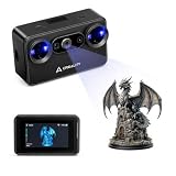
- Pocket-Sized & Wireless Freedom: At only 260g and 1006035mm, Pika fits in your palm. Features Wi-Fi 6 wireless PC mode, 3-inch HD touchscreen (500 nit), dual swappable 3350mAh batteries for extended sessions, and supports outdoor scanning up to 110,000 lux - scan anywhere, anytime without cables
- Dual-Mode Scanning with Blue Laser & NIR Structured Light: Switch between 7-line blue laser mode for fine detail capture and NIR structured light mode for full-body scanning with 24-bit true color. Scan objects from 101010mm to 200020002000mm - from tiny miniatures to life-size body scans - all with one device
- Ultra-High Precision 0.03mm Accuracy: Equipped with 7 parallel blue laser lines, Creality Pika delivers up to 0.03mm scanning accuracy and 0.1mm 3D resolution, capturing intricate details on small parts, figurines, mechanical components, and collectibles with professional-grade precision for 3D printing and reverse engineering
- AI-Powered Smart Features: Built-in AI Body Completion generates full-body 3D models from just a face scan and photos in as little as 10 seconds (10 faster). AI Retexturing maps real photo textures onto scanned models for lifelike results. AI Hole Filling automatically repairs incomplete scans for cleaner, print-ready output
- Scan Black & Metal Without Spray and Multi-Platform Export: Directly scans dark and metallic surfaces without scanning spray. Exports STL/OBJ/PLY/ASC formats compatible with all major 3D printing and CAD software. Works with Windows, macOS, iOS, and Android via CrealityScan app. Includes tripod, turntable, calibration board, and full accessories
Specify the capture before anyone scans
A scan is not automatically complete because a scanner was on site. The brief should define:
Quick wins for a faster PC:
Scan for outdated or missing drivers - takes under a minuteDriver Scan →Clear out junk files and repair common Windows errorsFree Scan →Fix the driver behind crashes, sound loss and screen glitchesFind Drivers →- Registration method and the control points or targets used to tie scans together.
- Coordinate system, project origin, units, and any required transformation.
- Point density or resolution appropriate to the decisions being made.
- Coverage, including roof spaces, plant rooms, service routes, and concealed areas that are accessible.
- Photographic coverage and whether colorized imagery is required.
- Occlusions, inaccessible zones, reflective or transparent surfaces, and other exclusions.
- File format, naming, viewer requirements, and how the cloud will be archived.
When the hybrid approach pays back
Use it when the cost of a wrong assumption about a crooked wall, slab level, structural connection, or existing service exceeds the cost of capture, registration, and cleanup. USIBD guidance is intended to help teams decide whether laser scanning benefits a project and evaluate a Building Documentation Professional. That makes the operator’s process and deliverables as important as the scanner itself.
For a single small, regular room with clear access and reliable dimensions, buying or commissioning a scan may add work without reducing a meaningful risk. For a building with many rooms, repeated clearances, or uncertain geometry, the same registered dataset can support design revisions, contractor questions, and later maintenance.
3. Selective 3D or massing: model only what needs coordination
Choose the areas with a decision attached
A lightweight model can include the rooms, roof, openings, structure, or MEP zones where a three-dimensional view changes a decision. Examples include checking a stair and headroom, fitting ductwork through a low ceiling, testing a kitchen layout against existing windows, or showing a roof junction to a client and trades.
Do not imply that a selective model is a complete as-built BIM. Label modeled elements, proxies, and unverified areas. Keep the point cloud or survey record available so users can inspect the underlying evidence.
What’s actually slowing this PC down?
Pick the symptom - the matching free tool is one click away.
Keep outputs useful to the site team
Export coordinated views, dimensions, sections, and details as stable 2D sheets or PDFs for trades. Name model versions and record the date of the geometry used. If an object is simplified, state the simplification—for example, a services zone shown as a clearance envelope rather than individual pipes. This prevents a visually convincing model from being mistaken for fabrication-level information.
Rank #3

- Wireless Scanning & Interactive Streaming: Built-in WiFi 6.0 enables on-the-go, structured light mobile scanning or real-time PC-to-mobile interactive scan streaming for seamless remote operations and more flexibility.
- Scan Challenging Surfaces Without Scanning Spray: Easily capture details on reflective or dark surfaces with 11 infrared laser lines, no scanning spray needed.
- Dual Scanning Modules: Boost scanning efficiency with INSPIRE 2's infrared structured light and multi-line laser scanning modes, making it easy to handle different materials, sizes, and environments.
- Accurate Models & Advanced Calibration: Create highly detailed models with an accuracy of up to 0.05 mm and precision of up to 0.03 mm. A high-precision calibration board boosts point cloud accuracy by 75%, ensuring consistent, precise data for 3D printing, reverse engineering, and detailed modeling.
- Outdoor Scans & Lightweight Design: Scan in outdoor environments with up to 20,000 lux lighting, ensuring reliable performance in shaded or semi-bright conditions. At only 190g, the INSPIRE 2 is lightweight, and its aerospace-grade aluminum alloy front panel offers increased durability and portability.
4. Point-cloud-first documentation for irregular or heritage buildings
Some buildings contain curved, settled, layered, or highly ornamented fabric. Classifying every ceiling, finish, and irregular surface into a full object database can consume more time than the intervention warrants. A point-cloud-first package keeps the registered scan, photographs, control information, and annotated views as the primary existing-condition record. CAD or selective 3D is then produced for the proposed work.
This approach is especially defensible when the project must show what was actually observed, when future investigators may need to revisit the evidence, or when the design affects only a small portion of a complex building. Separate raw evidence from interpretation: preserve the original scans and photographs, then issue cleaned derivatives and design drawings as separate files.
5. When full BIM is justified
Coordination across several disciplines
Full BIM earns its overhead when architecture, structure, and MEP must coordinate repeatedly and changes in one discipline create consequences in the others. A shared model can expose clashes and maintain coordinated views more reliably than a collection of unrelated drawings, provided the team agrees on modeling responsibility, issue procedures, and information levels.
Free tools Windows power users keep installed
One-click scans. No signup required.
Quantities, phasing, and asset information
If the client needs model-derived quantities, construction sequencing, asset registers, or a facilities handover, those requirements should be defined before modeling starts. Otherwise the team may build geometry that looks complete but lacks the properties, classifications, identifiers, or maintenance data needed at handover.
Mandated model exchange
Some owners or authorities specify a model deliverable. Agree on the required native format, model uses, validation rules, and exchange milestones in the contract. If different software will be used, request an open exchange requirement where appropriate.
buildingSMART defines IFC as “an open international standard for sharing Building Information Model (BIM) data.” Its specification covers a conceptual schema and exchange file format for information shared among construction and facility-maintenance participants. The Library of Congress notes that IFC can carry geometry, properties, quantities, materials, costs, schedules, and geospatial positions. IFC is therefore a useful future-interoperability path, but exporting an IFC file does not by itself prove that the model contains the data an owner needs. Test a sample exchange and inspect the required properties before committing to the workflow.
Rank #4

- Industrial-Grade Accuracy: Flawlessly capture intricate geometric details with up to a 0.01 mm single-frame precision and 0.015 + 0.04 mm x L (m) volumetric accuracy. Powered by advanced blue laser technology, the MetroY Ultra produces 3D is ideal for tight tolerance measurement, reverse engineering, and industrial inspection.
- 5 Versatile Scanning Modes: Handle every scenario, from small parts to medium-sized objects, with Metro Ultra's 5 scanning modes: 34 laser cross-lines for rapid scans, 15 parallel lines for fine details, a single-line mode for deep holes, full-field blue structured light for marker-free scans, and one-click automatic turntable scanning.
- Ultra-Fast 90 FPS Scanning Speed: Get scans done fast at up to 90 fps (NVIDIA GPU) or 60 fps (CPU). MetroY Ultra's 34-laser cross-line mode enables quick, large-area scans, reducing data acquisition time and boosting productivity without compromising data quality.
- No-Spray Scanning for Dark or Shiny Surfaces: Scan black, high-gloss, and metallic industrial components directly without scanning spray. Protect delicate parts from spray, save prep time, and keep a clean, professional inspection environment for sensitive equipment.
- Scan Outdoors: Capture industrial parts even in harsh sunlight up to 100,000 lux with MetroY Ultra's powerful laser-scanning modes.
How to choose: a project-specific decision rule
- Simple scope, reliable dimensions, one design discipline: use measured 2D CAD with explicit survey tolerances.
- Missing or suspect drawings, but modest coordination: capture a registered scan or photogrammetry dataset and draft the required 2D sheets.
- Crooked geometry, tight clearances, retained MEP, or repeated clash checks: use a point cloud plus selective 3D in the risk-heavy areas.
- Multi-discipline coordination, phased work, quantities, asset data, or mandated exchange: use full BIM and define an agreed IFC or other exchange requirement.
Compare each candidate on six questions: What survey accuracy and tolerance are needed? How much coordination risk crosses discipline boundaries? What deliverables will the authority, owner, and trades accept? Do the team’s software and skills support repeatable production? What is the total cost of capture, registration, drafting or modeling, revisions, and handoff? How likely is the information to be reused later?
Implementation checklist for a small existing-building renovation
- Define decisions and tolerances. List the dimensions, clearances, levels, and service locations that the design must trust. A survey without a decision target can collect either too little or unnecessarily dense information.
- Test the existing drawings. Perform a short field survey and compare critical dimensions before selecting CAD, scanning, or a hybrid. Treat discrepancies as evidence about drawing reliability.
- Write a capture specification if scanning. State registration, control, coordinate system, density, coverage, photographs, exclusions, file format, and acceptance checks.
- Separate evidence from interpretation. Store raw photos, scans, field notes, and control information separately from cleaned clouds, CAD, and design models.
- Declare model status. Identify elements that are measured, modeled, simplified, assumed, or unverified. Include the survey date and the source of critical dimensions.
- Issue stable construction information. Provide coordinated plans, sections, details, and views in the formats trades can use without specialized authoring software.
- Preserve future reuse. Retain the registered point cloud and, where a model handoff is likely, an agreed open exchange such as IFC. Document units, coordinates, versions, and required properties.
- Add a field-verification note. State that scans and drawings document observed conditions at a stated date; they do not remove the contractor’s duty to verify conditions before work.
Costs, staffing, and the break-even question
There is no authoritative universal price or time threshold at which BIM, scanning, CAD, or lightweight 3D becomes cheaper for every small renovation. Total cost includes field capture, registration and cleanup, drafting or modeling, software and training, coordination meetings, revisions, quality checks, and handoff—not just the scan or license.
Make the comparison project-specific. Estimate the consequence of a wrong assumption: demolition, a late structural change, a rerouted service, a failed inspection, or a return visit to measure inaccessible work. Then compare that exposure with the cost of obtaining better evidence or coordinating the affected area in 3D. Record the assumptions so the client understands why a workflow was chosen.
A 3D laser scanner is a reasonable equipment category when point-cloud capture is required, but a scanner is not automatically economical for a small room. Operator competence, registration quality, control, coverage, and deliverable management determine whether the result is usable. Existing-building laser scanning, scan-to-CAD, and scan-to-BIM are service categories to evaluate when the team lacks those capabilities. IFC-capable CAD and viewer software can support later interoperability when an open handoff matters.
Common failure modes and corrections
Using an old plan as truth
Symptom: dimensions close on paper but walls, openings, or services do not align on site. Correction: field-check critical dimensions, mark discrepancies, and issue a dated measured set rather than silently editing the old plan.
PC Slower Than It Used to Be?
A free scan shows the junk files, broken settings and background clutter dragging Windows down - then fixes them in one click.Free scan · Windows 10 & 11Outdated Drivers Are Slowing You Down
One free scan finds every outdated or missing driver and matches the right update for your exact hardware.Free scan · exact hardware matchScanning without a defined deliverable
Symptom: a large cloud arrives, but nobody knows its coordinate system, coverage, registration quality, or intended use. Correction: specify control, density, exclusions, naming, formats, and acceptance checks before capture.
Best Value

- Wireless Scanning & Interactive Streaming: Built-in WiFi 6.0 enables on-the-go, structured light mobile scanning or real-time PC-to-mobile interactive scan streaming for seamless remote operations and more flexibility.
- Scan Challenging Surfaces Without Scanning Spray: Easily capture details on reflective or dark surfaces with 11 infrared laser lines, no scanning spray needed.
- 【AI-Powered & Photo-Grade Retopology】 AI object segmentation (Windows only) identifies your target in one click, tracks it throughout the scan, and auto-filters background noise — delivering clean data and streamlining post-processing. The patented 3D Gaussian Splatting converts point cloud and RGB data into true-to-life 1:1 photorealistic models; import photos from your phone or camera to apply real textures, then export in splat format for gaming, animation, and VR.
- Dual Scanning Modules: Boost scanning efficiency with INSPIRE 2's infrared structured light and multi-line laser scanning modes, making it easy to handle different materials, sizes, and environments.
- Accurate Models & Advanced Calibration: Create highly detailed models with an accuracy of up to 0.05 mm and precision of up to 0.03 mm. A high-precision calibration board boosts point cloud accuracy by 75%, ensuring consistent, precise data for 3D printing, reverse engineering, and detailed modeling.
Treating a cloud as a finished design
Symptom: designers or trades assume every visible point is verified or that hidden services are represented. Correction: distinguish captured surfaces from interpretation, note occlusions, and keep unverified areas conspicuous.
Over-modeling existing fabric
Symptom: effort goes into classifying finishes and irregular surfaces that will not affect the intervention. Correction: retain the point cloud as evidence and model only the rooms, systems, or interfaces tied to a decision.
Issuing only a model to trades
Symptom: site teams lack dependable dimensions or cannot open the authoring file. Correction: issue stable 2D plans, sections, details, and views, with revision control and field-verification notes.
Assuming IFC guarantees interoperability
Symptom: an exchange file opens, but required properties, quantities, classifications, or relationships are missing. Correction: define the information requirements, export a test file, inspect it in the receiving software, and validate the required data before handover.
Bottom line for a small renovation
Choose measured 2D CAD when the scope is simple and the survey can be trusted. Add a registered point cloud when uncertainty in the existing building is the main risk. Add selective 3D where spatial coordination changes decisions. Reserve full BIM for projects that will repeatedly use coordinated data, quantities, phasing, asset information, facilities handover, or a mandated model exchange. In every case, document tolerances, preserve the evidence, state what is unverified, and require field verification before construction.
Quick Recap
Product prices and availability are accurate as of the date/time indicated and are subject to change. Any price and availability information displayed on Amazon at the time of purchase will apply.

