Free tools Windows power users keep installed
One-click scans. No signup required.
City of Vincent approved a Local Development Plan (LDP) covering the Charles Hotel and nearby North Perth properties in August 2024. That approval sets a planning framework for possible mixed-use development; it does not mean the pub is about to be demolished or that a final building design has been approved.
What council approved in August 2024
The City of Vincent unanimously approved an LDP for 11 sites across parts of Charles, Carrington and Eton streets. The proposal had first been lodged in January 2023, according to PerthNow. The council minutes list the covered addresses as 501, 503, 503B, 505–509 and 511–513 Charles Street, 4 Carrington Street, and 118–122 Eton Street, North Perth (City of Vincent council minutes, 20 August 2024).

PerthNow described the area as 11.3 hectares and reported that the sites were owned by Bridgeton Pty Ltd. Those are claims in its August 2024 report, not confirmation of current ownership or a separately verified area measurement.
What the framework allows—and what it does not decide
PerthNow reported that potential uses include housing, accommodation, restaurants or cafes, offices, bars and childcare. These are uses contemplated by the planning framework, not a confirmed schedule for a particular building or a final construction proposal.
#1 Best Overall
A City of Vincent transport assessment describes a mixed-use redevelopment concept with six development parcels, each potentially including a tower building. That concept-level assessment is not a final design or evidence of a construction timetable (Charles Hotel site, North Perth: Transport Impact Assessment, August 2023).
The Western Australian Planning Commission’s City of Vincent Local Planning Strategy separately identifies the Charles Hotel site, nearby vacant lots and a car park as a strategic development site. That designation provides wider planning context; it is not approval of a specific project (City of Vincent Local Planning Strategy).
Rank #2
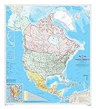
- 34 x 39 inches. Laminated. Flat map, tubed for shipping.
- This map shows North America at a scale of 1: 10 000 000. The map is a general reference map giving detailed coverage of populated places, transportation routes and the drainage network. Land areas are colored to represent individual countries and dependencies. The map sheet has three inset maps showing the Aleutian Islands (Alaska), Hawaii and the North America relief with significant mountain elevations. There is also a table of road mileages between major cities.
- Scale 1:10,000,000
Is the Charles Hotel about to be demolished?
The August 2024 LDP approval does not establish demolition approval, a detailed development approval, construction commencement or a confirmed redevelopment schedule. At the time, PerthNow quoted hotel owner Chris Angelkov saying there was “still a way to go” and that there were no plans to demolish the hotel “at the moment.” That was his reported position on 22 August 2024, not a statement of the owner’s current intentions.
Independent reader supportYour contribution helps us test, update, and keep practical guides available for everyone.What is known about the status now
The records cited here establish the City’s LDP approval in August 2024. They do not establish whether a later site-specific application has been lodged or approved, whether ownership has changed, or whether demolition or construction arrangements have since been made. Current council or state application records would be needed to determine those later developments.
The Tool Desk
Outbyte PC Repair FREEClear out junk files and repair common Windows errorsFree Scan →Outbyte Driver Updater FREEScan for outdated or missing drivers - takes under a minuteDriver Scan →Rank #3

- Large Print for easy reading
- Major Geographical features
- All counties and their capitals
- Size 36"W x 18"H inches (paper or laminated)
- Made/printed in U.S.A. 2022
It is therefore more accurate to describe the site as covered by an approved planning framework than as a confirmed or imminent redevelopment. “Boutique neighbourhood centre” is wording in PerthNow’s 2024 headline, not a formally established project name.
Quick Recap
Best Value

- Laminated durable tear resistant 24x28 HD Poster. Bold & vivid colors.
- Printed on high quality 24lb photo gloss paper. Heat sealed Lamination for years of protection.
- Ships same day it is purchased (weekdays)
- 100% Satisfaction guaranteed or full money back refund
- Poster Tags: Political Map North America Political Wall Map
Rank #4

- Country of Origin : United States
- The Package Height of the Product is 3.5 inches
- The Package Length of the Product is 24.5 inches
- The Package Width of the Product is 18.5 inches
Product prices and availability are accurate as of the date/time indicated and are subject to change. Any price and availability information displayed on Amazon at the time of purchase will apply.




