Reality capture measures the physical site, BIM structures project information, and a digital twin connects an asset record to current operational data. They are not competing names for the same deliverable. On a substantial construction project, they usually form a sequence: capture what exists, organize and coordinate it in BIM, then connect the completed asset to operations when ongoing decisions justify that investment.
The difference in one view
| Question | Reality capture | BIM | Digital twin |
|---|---|---|---|
| Primary purpose | Observe and measure physical conditions | Coordinate and manage structured project information | Monitor, analyze and operate the physical asset through connected data |
| Time reference | A capture event or survey epoch | Planned, current or as-built information set | Continuously or periodically refreshed operational state |
| Typical outputs | Point cloud, mesh, imagery, measurements and orthophoto | Objects, geometry, properties, relationships and documents | Asset model or graph linked to sensor, maintenance and event data |
| Main users | Surveyors, field engineers, VDC teams and inspectors | Designers, contractors, fabricators, owners and facility teams | Owners, operators, maintenance, energy, reliability and asset teams |
| Key uncertainty | Registration, coverage, occlusion, instrument and processing error | Missing properties, coordination errors and stale revisions | Data latency, sensor quality, identity mapping and model drift |
| Decision enabled | What exists, what changed and whether work matches conditions | What to build, how parts coordinate and what information to deliver | What is happening now, what may happen next and what action to take |
The terms describe different information layers. A point cloud is evidence collected from the site; it is not a BIM model. A coordinated as-built BIM is a structured information set; it is not automatically a digital twin. A twin needs a defined connection to ongoing asset information, although organizations use the term with different boundaries.
As an Amazon Associate I earn from qualifying purchases.
What reality capture does
Reality capture is the measurement and documentation layer. A field team records existing or as-built conditions with terrestrial or mobile laser scanning, photogrammetry, photographs, drones, 360-degree imagery or related sensors. The deliverable might be a registered point cloud, textured mesh, orthophoto, panoramic image set, measurement package or another set of observations.
Crashes, No Sound, or Screen Glitches?
Random freezes, missing sound and display glitches usually trace back to one bad driver. Find and replace yours safely.Free scan · under a minutePC Slower Than It Used to Be?
A free scan shows the junk files, broken settings and background clutter dragging Windows down - then fixes them in one click.Free scan · Windows 10 & 11The questions it answers
- What is physically present?
- Where is each visible feature, and how large is it?
- What changed since the previous survey?
- Does installed work match the drawings or the required location?
That makes capture particularly useful for existing-condition surveys, renovation, progress verification, clash investigation, quantity checks and handover evidence. It can expose a beam, service route or opening that differs from the record before the discrepancy becomes a fabrication or installation problem.
#1 Best Overall
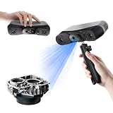
- 【Industrial-Grade Accuracy】Achieve single-frame accuracy up to 0.03 mm and volumetric accuracy of 0.03 mm + 0.05 mm x L(m), faithfully reproducing the finest surface details and complex geometries with exceptional consistency. Full-Field Structured Light accuracy reaches 0.08 mm; VCSEL mode delivers 0.10 mm @ 300-500 mm and 0.20 mm @ 500-800 mm. Engineered to meet the demanding requirements of 3D printing, reverse engineering, and precision modeling applications.
- 【Ultra-Fast Scanning & Robust Frame Rate】Multi-line Laser mode delivers up to 105 fps with NVIDIA GPU acceleration. Full-Field Structured Light mode achieves up to 5,000,000 points/s. The high frame rate ensures a smooth, uninterrupted scanning experience, especially suited for rapidly capturing large objects and complex scenes, significantly boosting overall workflow efficiency.
- 【AI-Powered & Photo-Grade Retopology】 AI object segmentation (Windows only) identifies your target in one click, tracks it throughout the scan, and auto-filters background noise — delivering clean data and streamlining post-processing. The patented 3D Gaussian Splatting converts point cloud and RGB data into true-to-life 1:1 photorealistic models; import photos from your phone or camera to apply real textures, then export in splat format for gaming, animation, and VR.
- 【All-Weather Outdoor Scanning】Multi-line Laser mode operates reliably up to 50,000 lux; with an outdoor filter attached, scanning remains stable in lighting conditions of up to 100,000 lux; VCSEL mode operates reliably in up to 100,000 lux ambient light. Designed to overcome lighting challenges, it provides consistent all-weather performance for construction sites, archaeological digs, and industrial fieldwork.
- 【5 Scanning Modes】NIR band supports Full-Field HD Scanning (markerless, fine structured light), Hybrid HD Scanning (dual projectors, fast high-quality modeling), and VCSEL Rapid Scanning (high-density pattern, fast markerless capture). Blue light band supports 30-Cross Laser Lines Scanning (handles high-reflectivity metals & dark objects) and Single-Line Deep Hole Scanning (captures from deep holes & narrow grooves). Five modes for comprehensive indoor and outdoor coverage.
What a capture does not provide by itself
Raw observations do not define design intent, object responsibility, classification, procurement status, maintenance procedures or operating limits. A scan can show a pipe and its position; it does not automatically identify the pipe’s system, specification, owner, inspection interval or replacement history. Those facts must be interpreted and structured in a model or connected information system.
Equipment choices
A 3D laser scanner is the clearest fit when the required product is a survey-grade point cloud for existing conditions or scan-to-BIM. Photogrammetry can derive measurements and models from overlapping photographs, while drones can cover roofs, facades and large sites efficiently where flight permissions, control and local regulations permit. A 360-degree construction camera provides rapid visual documentation and useful context, but it should complement—not be assumed to replace—survey-grade scanning when dimensional accuracy matters.
What BIM does
Autodesk defines BIM as “the holistic process of creating and managing information for a built asset” across planning, design, construction and operations. buildingSMART describes building information modelling as the use of “a shared digital representation of an asset to facilitate design, construction and operation processes to form a reliable basis for decisions.” In practical terms, BIM combines geometry with objects, relationships, classifications, properties, quantities, documents and agreed information exchanges.
How teams use BIM
- Design coordination: Federate architectural, structural and building-services models and check interfaces before work reaches site.
- Constructability and fabrication: Develop coordinated geometry and required properties for procurement, prefabrication and installation.
- Planning and control: Connect model elements to sequencing, packages, quantities or cost information where the project requires it.
- Commissioning and handover: Deliver asset information, documents and approvals in a form the owner can use.
BIM can represent an existing facility, a proposed design or an as-built condition. Its value comes from structured, governed information, not from the fact that the model is three-dimensional. A visually impressive model with missing identifiers, inconsistent classifications or unapproved revisions can still be an unreliable project record.
Rank #2
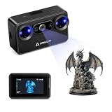
- Pocket-Sized & Wireless Freedom: At only 260g and 1006035mm, Pika fits in your palm. Features Wi-Fi 6 wireless PC mode, 3-inch HD touchscreen (500 nit), dual swappable 3350mAh batteries for extended sessions, and supports outdoor scanning up to 110,000 lux - scan anywhere, anytime without cables
- Dual-Mode Scanning with Blue Laser & NIR Structured Light: Switch between 7-line blue laser mode for fine detail capture and NIR structured light mode for full-body scanning with 24-bit true color. Scan objects from 101010mm to 200020002000mm - from tiny miniatures to life-size body scans - all with one device
- Ultra-High Precision 0.03mm Accuracy: Equipped with 7 parallel blue laser lines, Creality Pika delivers up to 0.03mm scanning accuracy and 0.1mm 3D resolution, capturing intricate details on small parts, figurines, mechanical components, and collectibles with professional-grade precision for 3D printing and reverse engineering
- AI-Powered Smart Features: Built-in AI Body Completion generates full-body 3D models from just a face scan and photos in as little as 10 seconds (10 faster). AI Retexturing maps real photo textures onto scanned models for lifelike results. AI Hole Filling automatically repairs incomplete scans for cleaner, print-ready output
- Scan Black & Metal Without Spray and Multi-Platform Export: Directly scans dark and metallic surfaces without scanning spray. Exports STL/OBJ/PLY/ASC formats compatible with all major 3D printing and CAD software. Works with Windows, macOS, iOS, and Android via CrealityScan app. Includes tripod, turntable, calibration board, and full accessories
Why IFC and property governance matter
IFC4.3 is an open international standard for exchanging BIM data across building and infrastructure software. Its scope includes project, physical, spatial, process, resource, control, actor and context information across lifecycle phases. Using IFC does not remove the need to agree which properties, classifications and exchange responsibilities apply to a particular project.
ISO 23386:2020 sets rules for defining and maintaining properties in interconnected data dictionaries so construction stakeholders can share information consistently. ISO reported that the 2020 edition was reviewed and confirmed current in 2025. A project should still state its chosen dictionaries, naming rules, required fields and approval process in its information requirements.
What a digital twin adds
A digital twin is an operational system built around a digital representation of a physical asset and connected to current or historical asset data. Depending on the owner’s definition, that data can include sensor readings, equipment states, maintenance records, alarms, energy measurements, inspections and performance events. A “data point” is a reading from a physical device or sensor in the terminology used by operational digital-twin documentation.
Free tools Windows power users keep installed
One-click scans. No signup required.
The practical test
Ask whether the system can receive, contextualize and use ongoing information about the physical asset. If it only stores a handover model and documents, it is more precise to call it an as-built BIM or asset information model unless the owner has explicitly defined “digital twin” more broadly.
Rank #3

- Wireless Scanning & Interactive Streaming: Built-in WiFi 6.0 enables on-the-go, structured light mobile scanning or real-time PC-to-mobile interactive scan streaming for seamless remote operations and more flexibility.
- Scan Challenging Surfaces Without Scanning Spray: Easily capture details on reflective or dark surfaces with 11 infrared laser lines, no scanning spray needed.
- Dual Scanning Modules: Boost scanning efficiency with INSPIRE 2's infrared structured light and multi-line laser scanning modes, making it easy to handle different materials, sizes, and environments.
- Accurate Models & Advanced Calibration: Create highly detailed models with an accuracy of up to 0.05 mm and precision of up to 0.03 mm. A high-precision calibration board boosts point cloud accuracy by 75%, ensuring consistent, precise data for 3D printing, reverse engineering, and detailed modeling.
- Outdoor Scans & Lightweight Design: Scan in outdoor environments with up to 20,000 lux lighting, ensuring reliable performance in shaded or semi-bright conditions. At only 190g, the INSPIRE 2 is lightweight, and its aerospace-grade aluminum alloy front panel offers increased durability and portability.
Decisions a twin can support
- Monitoring equipment condition or environmental performance.
- Diagnosing abnormal behavior by relating events to asset identity and location.
- Planning predictive or condition-based maintenance.
- Supporting remote operations and performance reviews.
- Testing what-if changes against current asset information.
The connection can be continuous or periodic. A twin does not become useful merely because more sensors are installed; each data point should support a named operational decision, have an owner and be refreshed at a frequency that decision requires.
How the three layers connect on a project
- Capture existing conditions. Collect scans, photographs, drone imagery or 360-degree imagery. Record the capture date, coordinate reference, coverage and expected uncertainty.
- Register and quality-check the data. Align and georeference scans or images, clean unusable data, check against survey control and document instrument, software, processing method, tolerances and areas not captured.
- Run scan-to-BIM when a structured model is needed. Interpret the point cloud and translate relevant geometry into BIM objects. Scan-to-BIM is not a one-click conversion: someone must decide which elements to model, the appropriate level of detail, required properties and acceptable deviation.
- Coordinate design and construction in BIM. Federate discipline models, check interfaces, attach required properties and exchange information through the agreed common data environment and approval workflow.
- Verify and update the as-built record. Use repeat capture checkpoints to compare installed work with the coordinated model. Update the information set with approved deviations, asset identifiers, documents and commissioning information.
- Connect operations when the use case warrants it. Link identifiers to commissioning data, sensors, maintenance systems and operational events. Define who owns each connection, how often data refreshes and what happens when a source is unavailable.
Scan-to-BIM in practical terms
Scan-to-BIM begins with a measured point cloud and ends with selected, structured model elements. The workflow normally includes survey planning, control, capture, registration, cleaning, segmentation, interpretation, modelling, validation and approval.
Before capture
- Set the coordinate system and control points that design and construction teams will use.
- Define the areas, elements and tolerances required for the intended decisions.
- Plan around occlusion: concealed or inaccessible surfaces cannot be recovered from a line-of-sight scan without another evidence source.
- Decide file formats, naming, security and the location for the authoritative data.
During processing and modelling
- Register stations or image sets and check residuals against control.
- Separate noise and irrelevant objects without deleting evidence needed for later review.
- Model only the elements and properties required by the agreed information requirements.
- Keep a link to the source capture so a modeller’s interpretation can be audited.
At acceptance
- Check model geometry against the point cloud or independent control.
- Verify object identifiers, classifications, property completeness and revision status.
- Record tolerances, confidence, date, author, instrument, software and exclusions.
- Obtain the responsible party’s approval before the model becomes the project record.
Choosing where to start
| Project problem | Start with | Reason |
|---|---|---|
| Uncertain renovation geometry or undocumented services | Reality capture | You need evidence of existing conditions before reliable design or coordination. |
| Multidisciplinary clashes, constructability or sequencing | BIM | The central need is structured coordination and shared information. |
| Progress verification or installation-location disputes | Reality capture linked to the BIM record | Repeatable observations can test work against the approved model. |
| Structured quantities, procurement or fabrication | BIM | Objects, properties and relationships must be managed consistently. |
| Energy, equipment or maintenance decisions after handover | Digital-twin planning | Operational data and asset identity must be connected to the record. |
Most substantial projects use all three, but not at the same intensity. Capture may be concentrated at survey and verification milestones; BIM may govern the whole delivery process; the twin may begin with a small set of high-value assets and expand only when operational decisions demonstrate a need.
What’s actually slowing this PC down?
Pick the symptom - the matching free tool is one click away.
Information quality and governance
Keep three quality questions separate. Reality-capture quality concerns measurement error, registration, coverage and occlusion. BIM quality concerns correct interpretation, coordination, properties, classifications and revision control. Digital-twin quality concerns identity mapping, sensor reliability, latency, continuity and whether the data still represents the physical asset.
Rank #4

- Industrial-Grade Accuracy: Flawlessly capture intricate geometric details with up to a 0.01 mm single-frame precision and 0.015 + 0.04 mm x L (m) volumetric accuracy. Powered by advanced blue laser technology, the MetroY Ultra produces 3D is ideal for tight tolerance measurement, reverse engineering, and industrial inspection.
- 5 Versatile Scanning Modes: Handle every scenario, from small parts to medium-sized objects, with Metro Ultra's 5 scanning modes: 34 laser cross-lines for rapid scans, 15 parallel lines for fine details, a single-line mode for deep holes, full-field blue structured light for marker-free scans, and one-click automatic turntable scanning.
- Ultra-Fast 90 FPS Scanning Speed: Get scans done fast at up to 90 fps (NVIDIA GPU) or 60 fps (CPU). MetroY Ultra's 34-laser cross-line mode enables quick, large-area scans, reducing data acquisition time and boosting productivity without compromising data quality.
- No-Spray Scanning for Dark or Shiny Surfaces: Scan black, high-gloss, and metallic industrial components directly without scanning spray. Protect delicate parts from spray, save prep time, and keep a clean, professional inspection environment for sensitive equipment.
- Scan Outdoors: Capture industrial parts even in harsh sunlight up to 100,000 lux with MetroY Ultra's powerful laser-scanning modes.
Minimum provenance for every update
- Capture or update date and responsible author.
- Instrument, sensor, software and processing method.
- Coordinate reference and registration or control information.
- Revision, approval status and intended use.
- Confidence, tolerance and known exclusions.
A BIM Execution Plan should set information requirements, model uses, roles, exchange formats, naming, approval, quality checks and handover responsibilities before production begins. It should also state which system is authoritative for geometry, asset identity, maintenance data and operational events.
Independent reader supportYour contribution helps us test, update, and keep practical guides available for everyone.Common mistakes and how to avoid them
Calling a point cloud BIM
A point cloud records observations; BIM adds interpreted objects, relationships and properties. Describe the point cloud as capture data and explain what modelling or classification has been performed.
Calling every handover model a digital twin
A handover model becomes a twin only under a definition that includes an operational connection. State the connected data sources and the decisions they support.
Buying equipment before defining the deliverable
Choose scanner, camera, drone or photogrammetry workflow after setting coverage, tolerance, control, access and output requirements. A fast visual record and a survey-grade point cloud solve different problems.
Best Value

- Wireless Scanning & Interactive Streaming: Built-in WiFi 6.0 enables on-the-go, structured light mobile scanning or real-time PC-to-mobile interactive scan streaming for seamless remote operations and more flexibility.
- Scan Challenging Surfaces Without Scanning Spray: Easily capture details on reflective or dark surfaces with 11 infrared laser lines, no scanning spray needed.
- 【AI-Powered & Photo-Grade Retopology】 AI object segmentation (Windows only) identifies your target in one click, tracks it throughout the scan, and auto-filters background noise — delivering clean data and streamlining post-processing. The patented 3D Gaussian Splatting converts point cloud and RGB data into true-to-life 1:1 photorealistic models; import photos from your phone or camera to apply real textures, then export in splat format for gaming, animation, and VR.
- Dual Scanning Modules: Boost scanning efficiency with INSPIRE 2's infrared structured light and multi-line laser scanning modes, making it easy to handle different materials, sizes, and environments.
- Accurate Models & Advanced Calibration: Create highly detailed models with an accuracy of up to 0.05 mm and precision of up to 0.03 mm. A high-precision calibration board boosts point cloud accuracy by 75%, ensuring consistent, precise data for 3D printing, reverse engineering, and detailed modeling.
Ignoring hidden or inaccessible conditions
Document occluded areas and avoid presenting inferred geometry as measured fact. Use photographs, drawings, targeted investigation or another capture method where the decision requires evidence.
Letting the model drift from the asset
Assign responsibility for updates, establish verification events and define what happens when equipment is replaced, sensors fail or a maintenance system changes an identifier.
Questions to settle before procurement
- Which decisions must the information support, and who will make them?
- What accuracy, coverage, level of detail and property completeness are required?
- Which coordinate system, classifications, exchange formats and common data environment apply?
- Who owns capture data, the coordinated model, asset identifiers and operational connections?
- How will deviations, approvals, revisions and exclusions be recorded?
- For a twin, which data points are needed, at what frequency, from which systems and with what fallback when data is late or missing?
Bottom line
Use reality capture to establish trustworthy evidence of the physical site. Use BIM to turn that evidence and the design into a coordinated, governed information record. Use a digital twin when the owner needs that record connected to live or historical operational data for monitoring, diagnosis, maintenance or performance decisions. The strongest workflow is not choosing one label; it is defining the information decision first and building only the layer needed to make it reliably.
Do these 3 things before closing this tab:
1Scan for outdated or missing drivers - takes under a minute2Clear out junk files and repair common Windows errors3Fix the driver behind crashes, sound loss and screen glitchesFrequently Asked Questions
Is reality capture the same as BIM?
No. Reality capture produces observations such as point clouds, imagery and measurements. BIM interprets and organizes information as objects with properties, relationships and documents.
Do I need a digital twin if I already have a BIM model?
Only if ongoing operational decisions require connected asset data. A BIM handover model can remain the authoritative as-built record without becoming a digital twin.
What equipment do I need for an as-built site?
The choice depends on the deliverable. A 3D laser scanner suits survey-grade point clouds and scan-to-BIM; photographs, 360-degree cameras, photogrammetry and drones can add context or cover particular areas, subject to access, control and local rules.
What is the biggest risk in scan-to-BIM?
Treating interpreted model geometry as if every element were directly measured. Record the source capture, modelling assumptions, tolerances, occlusions and approval status.
Quick Recap
Product prices and availability are accurate as of the date/time indicated and are subject to change. Any price and availability information displayed on Amazon at the time of purchase will apply.

