Recommended Free Tools
A vacant mall site is suitable for redevelopment only when a specific, lawful reuse can be delivered at an acceptable cost and risk. The same parcel may work for housing, employment space or a mixed-use district yet fail for a large retail scheme because of planning policy, contamination, access, infrastructure capacity, market demand or abnormal costs. Assess the proposed use—not the empty mall in isolation—through a staged review of control and planning, physical and environmental conditions, access and utilities, demand, financial viability and delivery.
Start with a use-specific decision, not a generic site score
“Is this vacant mall suitable?” is incomplete until you define what you want to build and what decision the assessment must support. An early screen for an acquisition needs less evidence than a planning application, while a site being considered for a plan allocation may require a different level of certainty again.
As an Amazon Associate I earn from qualifying purchases.
Define the decision stage
- Early screen: identify fatal constraints and plausible uses before spending on specialist surveys.
- Acquisition: establish control, access, major liabilities, demand and a credible value range before agreeing price or conditions.
- Plan allocation: test whether the site can contribute to the local development strategy, infrastructure network and place-making objectives.
- Planning application: provide the technical reports, design information, consultation evidence and mitigation commitments required by the local authority.
Develop a short list rather than assuming the mall should reopen as retail. Possible scenarios include a mixed-use neighbourhood, housing, employment space, community or institutional facilities, leisure, a smaller retail role, or a phased combination. Include a no-development or interim-use scenario where it is realistic. A feature that helps one use can hinder another: a large floor plate may suit storage or entertainment but create daylight, servicing and residential design problems. The U.S. Environmental Protection Agency’s reuse guidance states, “Keep in mind that an opportunity for one land use could be a constraint for another.”
Free tools Windows power users keep installed
One-click scans. No signup required.
Screen ownership, control and the planning framework
Confirm that the site can actually be controlled
Map the legal parcel and verify who owns each part of the former mall, car parks, service yards, access roads and adjoining development land. Review leases, restrictive covenants, easements, rights of way, ransom strips, options, charges, management-company arrangements and any ongoing occupation. A scheme cannot be delivered on land that cannot be assembled or accessed, even when its planning prospects look strong.
#1 Best Overall

- 📏【9999.11 Maximum Capacity】– U.S. Measuring units, Measures in feet and inches. Measure distance wheel against a usual tape measure and it will be the same measurements. Whether private or industrial purposes, the measurement of straight line and curve line is easy.
- 📏【Zozen Measuring Wheel】– One key reset, Larger bracket, Redesigned joints, Threaded TPR tires, Increased friction, Original location marker, Exquisite zozen tape measure and backpack. The handle features a large for more comfort.
- 📏【Portable & Accurate】– Through 2 tims folds can be folded to 16 inches into a backpack(included) for easy carrying and transport. Unfolded it extends to 40”. Adopts a precise gear structure design with an accuracy of±0.5%. the forward count increases, and the backward count decreases, effectively avoiding errors.
- 📏【Who Uses It】– The surveying wheel is great for indoor, outdoor projects, also ideal for real estate appraisers, law enforcement, construction workers landscaping workers and homeowners to measure your boundary lines of your property. Versatile enough to use on a variety of indoor and outdoor projects, this tool is ideal for real estate appraisers, law enforcement, construction or landscaping workers and homeowners alike.
- 📏【Different Environments】 – With sturdy, durable rubber, walking roller wheel is equipped for all environments – grass, concrete, gravel, dirt and more! STURDY – Walking wheels are great for professional work projects or school activities. Extremely accurate makes it extremely useful to measure the boundary lines of your property and neighborhood.
Check whether the mall building, parking areas or infrastructure are subject to separate ownership. Confirm rights to connect to roads and utilities and identify obligations to maintain shared structures. Obtain title information and a measured survey; a measuring wheel can help with an initial field estimate, but it does not establish a legal boundary or reliable development area. Use a qualified land surveyor when area, boundaries or levels affect a transaction or design.
Read the current local rules
Review the adopted development plan, zoning or equivalent controls, supplementary policies, designations, local-centre strategy, area-specific plans, heritage policies, nature protections and infrastructure requirements. Record the policy status and date of every relevant document. Ask the planning authority for a written view on the principle of each shortlisted use, the likely application route and any policy tests that will apply.
Planning tests are jurisdiction-specific. In England, the National Planning Policy Framework directs plan-makers to consider vacant and underused land, infrastructure availability, local market conditions, connectivity and place quality. Its town-centre policies give priority to considering suitable vacant centre sites before expanding boundaries and apply sequential and impact tests to certain retail and town-centre proposals. Those tests do not automatically govern a site elsewhere. Toronto, for example, uses regeneration-area and secondary-plan mechanisms in some locations. Treat these as illustrations of why the live local plan and regulations must be checked, not as portable rules.
Identify approvals beyond planning permission
- Building regulation, demolition and fire-safety approvals.
- Highway, access, traffic and public-transport approvals.
- Flood-risk, drainage, watercourse and environmental permits.
- Heritage consent, tree or landscape permissions and ecological licences.
- Utility diversions, easements and agreements with infrastructure operators.
- Environmental assessment, retail-impact or other sector-specific studies where local law requires them.
Ask the authority which studies are proportionate at each stage. Do not treat a pre-application conversation as a permission or as a substitute for a formal assessment.
Inspect the existing mall and the whole site
Record the physical baseline
Prepare a measured plan showing the parcel, buildings, structures, levels, access points, parking, service routes, plant areas, drainage assets, retaining walls and neighbouring uses. Record the building’s age, construction system, floor-to-floor heights, spans, loading capacity, roof condition, façade, fire compartmentation, lifts, stairs, mechanical and electrical plant, asbestos risk and any water or vandalism damage. Establish which elements can be reused, adapted or demolished.
Reuse is not automatically cheaper than demolition. A deep-plan mall may require major openings, new façades, shafts, sprinklers, acoustic treatment, insulation and vertical circulation to become housing or offices. Conversely, a sound structure with useful servicing and access may reduce programme and embodied-carbon impacts. Obtain an intrusive condition survey before relying on a reuse premium or a demolition saving.
Screen ground and environmental conditions
Start with a desktop review of historical mapping, environmental records, former fuel or chemical uses, waste storage, underground tanks, made ground, nearby industrial activity and regulatory notices. Follow with a site walkover looking for staining, distressed vegetation, vents, sumps, odours, damaged drainage and fly-tipping. The EPA reuse framework calls for site-characteristic analysis, environmental-condition analysis and land-use assessment; it also describes a market study as an evaluation of the economic viability of potential redevelopment options.
Rank #2

- 📏【Portable & Accurate】Through 2 times folds can be folded to 16 inches into a backpack(included) for easy carrying and transport. Unfolded it extends to 40 inches. Adopts a precise gear structure design with an accuracy of±0.5%. the forward count increases, and the backward count decreases, effectively avoiding errors.
- 📏【ZOZEN RED MEASURING WHEEL】Our measure wheel unique features: the red theme makes it easier to see the wheel, One key reset, Stronger bracket, Perfect joints, Threaded TPR tires, Increased friction, Original location marker, Exquisite Zozen backpack. The handle features a large for more comfort.
- 📏【10,000 FEET CAPACITY】 U.S. Measuring units, Measures in feet/ inches. Measure distance wheel against a usual tape measure and it will be the same measurements. Whether private or industrial purposes, the measurement of straight line and curve line is easy.
- 📏【Who Uses It】– The surveying wheel is great for indoor, outdoor projects, also ideal for real estate appraisers, law enforcement, construction workers landscaping workers and homeowners to measure your boundary lines of your property. Versatile enough to use on a variety of indoor and outdoor projects, this tool is ideal for real estate appraisers, law enforcement, construction or landscaping workers and homeowners alike.
- 📏【Different Environments】 – With sturdy, durable rubber, walking roller wheel is equipped for all environments – grass, concrete, gravel, dirt and more! STURDY – Walking wheels are great for professional work projects or school activities. Extremely accurate makes it extremely useful to measure the boundary lines of your property and neighborhood
Desktop work and a walkover identify issues; they do not certify that contamination is absent. Commission proportionate phase-one and, where indicated, intrusive contamination, geotechnical, asbestos, ecology, flood, drainage and heritage investigations. Consider vapour, groundwater, gas, buried obstructions, unstable fills, settlement, radon where relevant, protected species and archaeological potential. Match the investigation to the proposed use: residential development generally needs a more demanding human-health and garden-soil assessment than a sealed warehouse, while a school or care use may require additional safeguards.
Map constraints and opportunities spatially
Place every constraint on a single plan with a confidence rating and an owner for resolving it. Include flood zones, surface-water flow paths, wetlands, watercourses, trees, habitats, heritage assets, rights of way, easements, steep slopes, noise sources, odour, air quality, neighbouring hazards and existing services. Mark opportunities such as a transit stop, an intact structural grid, a high-capacity substation or a serviceable district-heating connection. A constraint is not fatal until its effect on the selected use, mitigation, cost and programme are understood.
Test access, transport and infrastructure capacity
Assess movement at the site boundary and beyond it
Measure the capacity and geometry of every vehicular access, junction, service route, fire appliance route, pedestrian connection and cycle link. Check ownership and adoption status, visibility, gradients, turning, bridge limits and rights to alter the highway. Analyse existing traffic, collision history, public-transport frequency, walking catchments, cycle networks, parking controls and delivery patterns. A large former car park does not prove that a dense scheme has adequate transport capacity.
Consider construction traffic separately from operational traffic. Identify haul routes, crane positions, neighbour interfaces, temporary closures and requirements for a construction logistics plan. For a phased scheme, ensure the first phase does not remove the access or utilities needed by later phases.
The Tool Desk
Outbyte PC Repair FREERepair Windows errors before they cause bigger problemsFix Now →Outbyte Driver Updater FREEScan for outdated or missing drivers - takes under a minuteDriver Scan →Verify utilities and drainage with providers
Request capacity and connection information for potable water, foul sewer, surface-water drainage, electricity, gas where relevant, heat networks and digital connectivity. Confirm the location, ownership, easements, remaining capacity, connection point, lead time and reinforcement cost. Include off-site networks: a pipe or cable visible at the boundary may not have capacity for the proposed intensity.
Test drainage hierarchy, discharge rates, attenuation volume, exceedance routes, water-quality treatment and maintenance responsibility. Site-specific costs may include access roads, sustainable drainage, utilities, green infrastructure and decentralised energy. Existing plant may be obsolete, contaminated or legally unavailable to a new owner. Obtain written provider responses and allow for design development, connection charges and programme risk.
Use a capacity schedule
| System | Evidence to obtain | Typical decision |
|---|---|---|
| Roads and junctions | Geometry, ownership, traffic data, upgrade requirements | Can the proposed scale be safely served? |
| Public transport | Stops, frequency, capacity, walking and cycle connections | Can travel demand be accommodated without an unrealistic mode split? |
| Water and sewer | Point of connection, hydraulic capacity, reinforcement and lead time | Is the use deliverable, and what off-site work is required? |
| Surface water | Flood maps, infiltration tests, discharge limits, storage and exceedance routes | Can drainage meet policy and climate allowances? |
| Electricity and heat | Available capacity, substation condition, connection cost and programme | Can the building’s loads and decarbonisation strategy be supported? |
| Digital connectivity | Existing ducts, providers, resilience and upgrade needs | Can the intended occupiers receive adequate service? |
Prove demand for each reuse option
Build a market question before commissioning a report
Ask what evidence would show that a particular use can attract users, occupiers or buyers at the assumed value. A market study should address population and economic conditions, competing supply, vacancy, rents or sales, achievable lease-up or absorption, potential users, employment or housing demand and the site’s role in the wider town or district.
Rank #3

- 📏【Zozen Green Measuring Wheel】One key reset, Larger bracket, Redesigned joints, Threaded TPR tires, Increased friction, Original location marker, Exquisite Zozen backpack. The handle features a large for more comfort.
- 📏【Portable & Accurate】Through 2 tims folds can be folded to 16 inches into a backpack(included) for easy carrying and transport. Unfolded it extends to 40 inches. Adopts a precise gear structure design with an accuracy of±0.5%. the forward count increases, and the backward count decreases, effectively avoiding errors.
- 📏【9999.11 Maximum Capacity】U.S. Measuring units, Measures in feet and inches. Measure distance wheel against a usual tape measure and it will be the same measurements. Whether private or industrial purposes, the measurement of straight line and curve line is easy.
- 📏【Who Uses It】The surveying wheel is great for indoor, outdoor projects, also ideal for real estate appraisers, law enforcement, construction workers landscaping workers and homeowners to measure your boundary lines of your property. Versatile enough to use on a variety of indoor and outdoor projects, this tool is ideal for real estate appraisers, law enforcement, construction or landscaping workers and homeowners alike.
- 📏【Different Environments】With sturdy, durable rubber, walking roller wheel is equipped for all environments – grass, concrete, gravel, dirt and more! STURDY – Walking wheels are great for professional work projects or school activities. Extremely accurate makes it extremely useful to measure the boundary lines of your property and neighborhood.
For housing, test tenure, unit sizes, affordability, pipeline supply, sales rates, rents, household growth and competing schemes. For employment, examine sector demand, floor-plate requirements, rents, incentives, vacancy, labour access, servicing and broadband. For leisure or community uses, identify operator requirements, catchment population, travel patterns, competing facilities, opening hours, noise and parking. For retail, assess existing-centre health, shopping patterns, trade draw, vacancy, tenant demand and the effect of a new scheme on nearby centres.
PC Slower Than It Used to Be?
A free scan shows the junk files, broken settings and background clutter dragging Windows down - then fixes them in one click.Free scan · Windows 10 & 11Outdated Drivers Are Slowing You Down
One free scan finds every outdated or missing driver and matches the right update for your exact hardware.Free scan · exact hardware matchUse evidence that matches the decision
- Early screen: local statistics, planning pipeline, property listings, comparable rents or sales and interviews with potential users.
- Acquisition: independent demand and competition analysis, operator testing, absorption scenarios and sensitivity to incentives and vacancy.
- Planning: a documented catchment, trade or employment analysis and the methodology required by the local authority.
Do not infer demand from the mall’s former popularity. Shopping patterns, household needs, work patterns and leisure preferences may have changed substantially. A proposed use must have a credible route to occupation, not merely a visually attractive concept.
Build a transparent viability model
Separate value, cost and risk
For each scenario, estimate development value and development costs with the source and date of every assumption. Costs should cover acquisition, demolition or adaptation, construction, abnormal ground and contamination work, infrastructure and access upgrades, professional fees, surveys, planning obligations, finance, taxes where applicable, marketing, phasing and the required developer return. Include landowner premium or existing-use considerations where relevant.
A simple residual structure is:
Residual land value = development value − total development costs − finance − policy obligations − required developer return − risk allowance.
This is a decision model, not a valuation conclusion. Development value should reflect achievable rents, sales, yields, incentives, vacancy and timing. Construction costs must reflect the actual form, specification, abnormal works and market date. A low asking price does not prove viability, and a high asking price does not prove that the scheme can support it.
Make uncertainty visible
Do not hide unknowns inside one contingency. Create a risk register stating the issue, probability, cost range, programme effect, mitigation, responsible party and investigation needed. Run sensitivities for sales values or rents, build cost inflation, interest rates, remediation, utility reinforcement, planning obligations, absorption, phasing and exit yield. Use downside cases that combine correlated risks, such as slower take-up alongside higher finance costs.
Compare options on a consistent basis
| Assessment axis | Evidence to assemble | Decision it informs |
|---|---|---|
| Planning and legal | Current plan or zoning, designations, ownership, leases, easements and approvals | Is the use allowed, controlled and accessible? |
| Physical and environmental | Building condition, contamination, flood, ecology, heritage and geotechnical findings | Can constraints be mitigated for this use, at what cost and in what time? |
| Infrastructure and access | Utility capacity, roads, transit, drainage, digital access and upgrade requirements | Can the site support the intended intensity? |
| Market | Demand, vacancy, rents or sales, competition and absorption | Is there a credible occupier or buyer market? |
| Financial | Development value, construction and abnormal costs, obligations, land value and return | Does the option work under realistic assumptions? |
| Delivery | Phasing, ownership, approvals, funding, capability and dependencies | Can it be built within a realistic programme? |
Plan phasing and delivery, not just the end state
Test a sequence that can operate safely
Set out enabling works, demolition, remediation, infrastructure, first phase, later phases and final public-realm works. Identify which roads, drainage, substations, fire routes and temporary facilities must be delivered before occupation. Check whether an early phase generates enough value or activity to fund later work, and whether the scheme remains usable if a later phase is delayed.
Rank #4

- 📏【Adjustable and Easy to Use】The Zozen 6-Inch Measuring Wheel has 3 adjustable sections of rods that can be fixed to any length, with a one-key reset, stronger bracket, perfect joints, TPR tires, and an original location marker. It comes with an exquisite carrying bag for easy transport and storage, making it lightweight and portable.
- 📏【10,000 FT Capacity】 U.S. Measuring units, Measures in feet/ inches. Measure distance wheel against a usual tape measure and it will be the same measurements. Whether private or industrial purposes, the measurement of straight line and curve line is easy.
- 📏【Portable & Lightweight】Through 2 tims stretch can be stretch to 17 inches into a backpack(included) for easy carrying and transport. Unfolded it extends to 37”. Versatile enough to use on a variety of indoor and outdoor projects. Flexible telescopic pole allows you to use it in higher terrain.
- 📏【Accurate & Flexible】Adopts a precise gear structure design with an accuracy of±0.5%. the forward count increases, and the backward count decreases, effectively avoiding errors. And Zozen Use duodecimal number system, Make it easier for you to read data.
- 📏【Who Uses It】– The surveying wheel is great for indoor, outdoor projects, also ideal for real estate appraisers, law enforcement, construction workers landscaping workers and homeowners to measure your boundary lines of your property. Versatile enough to use on a variety of indoor and outdoor projects, this tool is ideal for real estate appraisers, law enforcement, construction or landscaping workers and homeowners alike.
Consider meanwhile uses—such as community, cultural, storage or temporary commercial activity—only where they are lawful, safe, insured and compatible with construction. They may improve security and place quality, but they can also create relocation obligations, lease complications and additional fit-out costs.
Assign responsibility for dependencies
Create a delivery schedule naming the landowner, developer, authority, utility operator, highway authority and prospective operators for every dependency. Record the approval, evidence, cost, lead time and decision date. A scheme that relies on an unconfirmed junction upgrade, land transfer or utility reinforcement is not ready for an unconditional conclusion.
Distinguish fatal constraints from solvable problems
Potentially fatal constraints
- No realistic control of the land or legally usable access.
- A proposed use prohibited by the current plan with no credible policy or plan-making route.
- Unacceptable flood, ecological, heritage, safety or contamination impacts that cannot be mitigated.
- Infrastructure or highway requirements that are unavailable, legally impossible or disproportionate to site value.
- No evidenced market for any plausible use.
- A persistent viability gap after realistic costs, obligations, finance and return are included.
Usually mitigable constraints
- Contamination with a defined remediation strategy and cost range.
- Obsolete structures that can be adapted or selectively demolished.
- Weak pedestrian connections that can be improved through an agreed public-realm scheme.
- Drainage or utility shortfalls with a funded reinforcement route.
- Phasing, design or mix issues that can be changed without undermining demand.
Label each issue as fatal, mitigable or unresolved. “Unresolved” means evidence is missing; it is not permission to assume the favourable outcome.
Use a decision gate before committing more money
- Gate 1—control and policy: confirm ownership, access, designations and the planning route. Stop or redesign if the intended use has no credible legal path.
- Gate 2—site risk: complete desktop and walkover screening. Commission intrusive studies only for options that survive the first gate.
- Gate 3—infrastructure: obtain provider and highway responses, including off-site works, cost and lead time.
- Gate 4—market: test demand, competition, achievable values and absorption for each surviving option.
- Gate 5—viability: model value, all costs, obligations, finance, return, phasing and downside sensitivities.
- Gate 6—delivery: agree a land, approval, funding and construction programme with named responsibilities.
- Gate 7—decision: proceed, proceed subject to named evidence, change the use or phase, hold for a defined trigger, or reject the site.
The appropriate conclusion may be “promising subject to a phase-two intrusive survey, utility confirmation and a revised market test,” rather than an unconditional yes or no. State exactly what must be proved, who will prove it and by when.
Common assessment mistakes and how to avoid them
Scoring the parcel without specifying a use
A generic high score conceals conflicts between uses. Score each scenario separately, then explain which physical features change from asset to constraint.
Assuming existing infrastructure is usable
Verify capacity, ownership, condition and connection rights. A visible pipe, road or substation may be too small, privately controlled or due for replacement.
Do these 3 things before closing this tab:
1Clear out junk files and repair common Windows errors2Fix the driver behind crashes, sound loss and screen glitches3Repair Windows errors before they cause bigger problemsTreating desktop evidence as a clean bill of health
Historical records and a walkover guide investigations; they do not replace contamination, geotechnical, ecological, flood, heritage or building surveys where risk warrants them.
Best Value
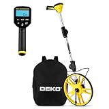
- 📏【Professional & Precision】The DEKOPRO digital measuring wheel is a rare high-precision distance measuring wheel on the market. Its measurement units can be switched between feet and meters at any time. Featuring a precision gear structure design, it is suitable for professional use. Forward counting increments and backward counting decrements effectively prevent errors.
- 📏【Portable & Premium Materials】The digital measuring wheel folds twice to a compact 15.5 inches, fitting easily into the included backpack for convenient carrying and transport. When extended, it reaches up to 40 inches. Featuring a reinforced frame, seamless joints, and premium TPR tires for enhanced traction, it displays data on a clear LCD screen.
- 📏【Powerful Features】Unit Conversion: Switch between metric and imperial units anytime; Pause Function: Prevents measurement errors; Data Storage: Stores up to 5 readings with instant recall; Clear Function: One-touch reset to zero; Backlit Display: Enables nighttime operation. All buttons feature IP54 waterproof and dustproof protection.
- 📏【Multi-Scene Applications】The measuring wheel is suitable for various indoor and outdoor projects such as highways, runways, and lawns. This rolling measuring wheel is an ideal choice for real estate appraisers, law enforcement officers, construction or landscaping workers, and homeowners.
- 📏【What You Get】1x Digital Display Measuring Wheel, 1x Instruction Manual, 1x Data Cable, 1x Storage Pouch, 1x Paper Box Packaging. This rolling distance measuring wheel can measure any type of distance. Simply walk with this measuring wheel device, and the entire measurement process becomes fun and easy.
Using a residual land value to conceal missing costs
List abnormal works, obligations, professional fees, finance, phasing and return separately. Show sensitivity ranges and the investigation that would narrow each range.
Relying on former retail performance
Past footfall does not establish present demand. Test current catchment conditions, competing supply, vacancy, rents, user requirements and absorption.
Transferring another jurisdiction’s policy test
England’s town-centre and viability guidance, U.S. EPA reuse framework and Toronto’s planning mechanisms answer different legal questions. Use them as assessment concepts only after checking the current local law and plan for the site.
What’s actually slowing this PC down?
Pick the symptom - the matching free tool is one click away.
What the final feasibility pack should contain
- A location plan, legal-boundary plan and ownership or control schedule.
- A policy and approvals register with document dates and unresolved questions.
- Existing-condition, measured-survey and building-reuse or demolition findings.
- Environmental, flood, drainage, ecology, heritage and geotechnical risk summaries.
- Access, transport and utility capacity plans, including off-site upgrades.
- A market report for every shortlisted use, with demand, competition, vacancy, values and absorption.
- Concept plans showing achievable scale, servicing, public realm, phasing and retained or demolished structures.
- A cost plan with abnormal items, assumptions, exclusions, contingencies and dates.
- A viability model with development value, finance, obligations, land value, return and sensitivity cases.
- A risk register and delivery programme naming dependencies and responsible parties.
- An option comparison and a decision statement identifying fatal, mitigable and unresolved constraints.
Keep an audit trail for every material assumption. Market values, construction costs, utility capacity and physical conditions change over time, so date the pack and set a review trigger before acquisition or application.
How to reach a defensible conclusion
Call the site suitable only for a defined scheme whose planning route, land control, physical condition, infrastructure, demand, financial case and delivery path are all credible. Call it unsuitable when a fatal constraint or durable market or viability failure remains after reasonable alternatives have been tested. If important evidence is incomplete, use a conditional conclusion with specific studies, approvals, cost limits and decision dates.
The cited English planning pages available for this framework show 2026 versions, while the EPA reuse material is older and should be checked for later agency updates before project reliance. Regardless of location, confirm the live plan and regulations, infrastructure-provider responses, environmental records, market evidence and cost assumptions for the actual parcel.
Quick Recap
Product prices and availability are accurate as of the date/time indicated and are subject to change. Any price and availability information displayed on Amazon at the time of purchase will apply.
Quick wins for a faster PC:
Scan for outdated or missing drivers - takes under a minuteDriver Scan →Clear out junk files and repair common Windows errorsFree Scan →
