Some links on this page are affiliate links: if you buy through them we may earn a commission, at no extra cost to you.
Google Earth can give you a useful preliminary roof-area estimate: draw a polygon around each visible roof plane, record its area, then adjust for roof pitch if you know it. The result is a horizontal, plan-view measurement—not automatically the true sloped surface area or a field-verified material takeoff. Google warns that measurements are estimates, may not be fully accurate, and do not account for elevation changes. Google Earth measurement guidance
What you need before measuring
- The property address and a clear satellite view of the roof.
- Google Earth on a computer, either the web version or Google Earth Pro.
- A calculator or spreadsheet to total roof planes and apply pitch factors.
- The roof pitch, if available from plans, a previous report, or an onsite measurement.
- Notes about trees, shadows, additions, and other areas the imagery does not show clearly.
Check the imagery date if it is available. An image can be clear but outdated, or recent but obscured. Confirm that you have the right building by comparing its driveway, orientation, lot, and neighboring structures.
Measure a roof in Google Earth on the web
- Open Google Earth on a computer and search for the property.
- Switch to the satellite basemap and get a straight-down, top-down view. Avoid measuring from a tilted 3D view; Google recommends top-down viewing for the best measurement results.
- Zoom in until roof edges are distinguishable, while keeping the whole roof easy to interpret.
- Click Measure. Google Earth switches to a top-down view if needed.
- Click around the outline of one roof plane. Add a point wherever the edge changes direction rather than forcing an irregular outline into a few broad corners.
- Close the shape by connecting to the first point, or double-click the last point and select Done. Read the area in the measurement panel.
- Use the unit dropdown beside the result, or go to Settings → Formats and units, to choose the units you need. For a U.S. roofing estimate, use square feet.
- Drag points to refine the outline. Select Start New to measure another plane.
For the full current workflow and its limitations, see Google’s measurement instructions.
Recommended Free Tools
Measure in Google Earth Pro
- Open Google Earth Pro and navigate to the property.
- Select Tools → Ruler, then choose Polygon.
- Click around the roof plane. Close the shape to display its area.
- Choose Save if you want to keep the measurement under Places; name it so you can identify the plane later.
- To revisit a saved measurement, open it under Places. Right-click and choose Properties on Windows or Get Info on Mac to inspect or edit it.
To change units, use Tools → Options → Units of measurement on Windows or Google Earth → Preferences → Units of measurement on Mac. Google Earth Pro offers a desktop workflow and saved measurements; it does not make the result a verified roof takeoff or automatically resolve pitch. See Google’s Pro measurement instructions.
#1 Best Overall

- EASY-TO-USE: This laser measure features a simple, user-friendly layout with two-button operation: one for measuring, one for rounding
- ACCURATE: This laser measuring tool features long range measuring with extreme accuracy. It measures distances up to 100 feet to within 1/16 inch, in meters, feet, inches, with fractions or decimals
- DISPLAY: BOSCH Blaze laser measure features a backlit display with large icons that allows measurements to be easily read, even in dark areas. It is brighter than its predecessor, the GLM20
- PORTABLE: This compact laser measurement tool is easy to carry and fits in your pocket
- ROUNDING BUTTON: On this digital measuring tool, the button allows users to easily round the measurement result from 1/2 inch up to 1/32 inch
Trace the roof planes, not just the house footprint
On a simple roof, trace the visible outside roof edge—not the walls—if the eaves and overhang are clear. A gable roof may look like one rectangle from above, but it has two sloping planes divided by a ridge. If the ridge is visible, measure the two sides separately so you can account for their pitches independently.
For a roof with additions, dormers, a garage, porch, or different roof levels, make separate polygons for the visible sections. Name each one—for example, “Main front plane,” “Garage,” or “Porch”—and check that every section is included once, with no gaps or overlap. Do not draw one large polygon over the entire building if ridges, valleys, or different elevations separate the roof into distinct planes.
Google Earth may show only part of a plane. Trees, shadows, roof overlap, image stitching, and blurred edges can hide boundaries. Do not guess the hidden portion and treat it as measured. Mark it as uncertain and get another measurement method if it affects the estimate materially.
Do these 3 things before closing this tab:
1Scan for outdated or missing drivers - takes under a minute2Repair Windows errors before they cause bigger problems3Fix the driver behind crashes, sound loss and screen glitchesRank #2

- ★ HIGH ACCURACY & UNIT SWITCHABLE ★ With unique 2 Bubble Levels, providing more precise measurement compared to one bubble;With laser precision technology, accuracy ups to ±1/16inch, measuring distance extends to 328 feet; Switchable among M/In/Ft for free adjustment
- ★ LCD BACKLIGHT & MUTE SETTING ★ Large backlight screen provides you with a better visibility in dark areas; Mute setting allows you turn on or off the measure beep at your will, suitable for using in library, classroom and other quite places,the laser level is ideal for home, construction and industries, especially in large areas such as rooms, apartments, buildings, real estates, factories, warehouses, etc
- ★ MULTIPLE MEASUREMENT FEATURES ★ Area, distance, length, volume, continuous measurement, Pythagorean method-three points; Addition and subtraction; Low battery indication; 20 groups data memory; Manually delete data; Auto shut down after 150s without any operation to save power
- ★ DURABLE AND HANDY DESIGN ★ IP54 waterproof level and dust-proof function protect the laser distance measure to the maximum extent; Portable size provides a good grip; Wrist strap lets you hold the meter steady and carry easily
- ★ WHAT YOU GET ★ Rockseed Laser Measuring Device 328Ft; 1.5V AAA Batteries; User Manual; Hand Strap; Package Box; (Ideal thanksgiving gifts and christmas gifts for family and friends)All ROCKSEED products are certified by international standards including CE, FCC, and ROHS, with an IP54 rating (splash and dust resistant). We provide 2 years of technical support and after-sales service for laser measuring tools in the United States.
Plan area is not sloped roof area
Google Earth’s standard polygon measurement gives the area of the outline projected onto the map. It does not account for changes in elevation, so a sloped plane’s actual surface is larger than its horizontal projection. A low-slope roof may be close to the plan-view result; a steeper roof can differ substantially.
If you know the pitch, use this factor to estimate the sloped area:
Pitch factor = √[1 + (rise ÷ run)²]
Roof pitch is commonly written as rise over 12 inches of horizontal run. For example, a 6/12 pitch rises 6 inches for every 12 inches of run. Multiply the plane’s Google Earth plan area by its pitch factor:
Rank #3

- POCKET-SIZED LASER MEASURE: This laser distance measure fits into a pocket or tool belt, and the blaze pro measurer still has 165 ft. range, a backlit display, multiple measuring features and a 10-measurement storage capability
- EASY-TO-READ BACKLIT DISPLAY: This laser distance meter illuminates numbers with distinct resolution, allowing work in low-light or no-light conditions
- DEFAULT REAL-TIME MEASUREMENT MODE: This laser distance measuring tool immediately provides accurate measurement that automatically adjusts closer to or farther from the target
- ADD/SUBTRACT MEASUREMENTS: This laser measurement tool allows the user to add or subtract measurements
- MULTIPLE MEASURING FEATURES: BOSCH Blaze laser measure calculates distance, square footage, volume and indirect measurements
Estimated sloped area = plan area × pitch factor
| Pitch | Approximate factor |
|---|---|
| 0/12 | 1.000 |
| 2/12 | 1.014 |
| 3/12 | 1.031 |
| 4/12 | 1.054 |
| 5/12 | 1.083 |
| 6/12 | 1.118 |
| 7/12 | 1.158 |
| 8/12 | 1.202 |
| 9/12 | 1.250 |
| 10/12 | 1.302 |
| 12/12 | 1.414 |
These are mathematical factors, not pitch readings from Google Earth. For example, a 1,800-square-foot plan area at 6/12 is approximately 1,800 × 1.118 = 2,012 square feet of sloped surface, before any material waste allowance.
Do not apply one factor to the whole roof if planes have different pitches. Calculate each plane separately and add the adjusted areas: (plane 1 area × its factor) + (plane 2 area × its factor) + so on. Google Earth is not a reliable general-purpose roof-pitch detector. Check plans or an existing roof report, or have pitch verified by a qualified person. An elevation profile in Google Earth Pro shows elevation and distance along a path; it is not an automatic measurement of an individual roof plane’s pitch.
Convert the estimate to roofing squares
In U.S. roofing terminology, one roofing square is 100 square feet. Divide the estimated sloped roof area by 100 to convert it to squares. In the example above, 2,012 square feet is 20.12 squares before waste.
Rank #4
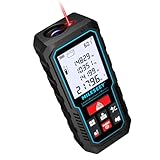
- [Reliable and Efficient] Upgraded electronic level with accuracy up to +/-0.3°and laser tape measure with accuracy up to +/-2mm, MILESEEY D5 delivers more accurate and faster measurements of angle and distance than bubble level meters. And with real-time display of electronic angle, it is much easier for users to find the horizontal direction, which guarantees high-accuracy measure results
- [UNIQUE FUNCTIONS] The high precision laser head component can be measured quickly and accurately in 0.5s, Auto-Level: Only measure the hypotenuse, the horizontal distance and vertical height will be calculated automatically; Auto-height: Only measure 2 hypotenuses, the vertical height will be calculated automatically; Fast measurement: automatic calculation of area and volume with one button operation
- [PRACTICAL MULTIPLE Measurements] 70M laser distance measure accuracy +/-1/16 inch (+/-2mm), and it offers automatic calculation of area, volume and distance, continuous measurement, pythagorean method-3points to meet your different measuring needs.; good laser measuring device for covering large area:home decoration, especially in large areas such as apartments, buildings, real estates, factories, warehouses, construction and industries
- [UNITS SWITCH & 30 DATA RECORDS & Energy-saving Design] freely switch the units in M/ FT/IN/ft+in; 30 data records and recall function which are useful for reviewing and calculating; portable Pocket-sized, non-slip design; 180s of automatic shutdown to save the power, can work up to 5000 times
- [24 MONTHS+ INTERNATIONAL CERTIFICATE] 1 x digital measure laser, 2 x 1.5 V AAA, 1 x user manual, 1 x portable bag, 1 x portable bracelet; CE / FDA / ROHS/ WEEE certification, IP54(splash-proof and dust-proof), We always provide 2-year assurance and technical support for laser measurement tool
Do not treat that number as a final order quantity. Waste depends on roof shape, hips and valleys, dormers, cuts, material dimensions, penetrations, starter strips, eaves and rakes, and packaging or delivery requirements. A simple roof and a cut-up roof do not necessarily need the same allowance. Get the material-specific allowance from the contractor or supplier rather than applying a universal percentage.
Independent reader supportYour contribution helps us test, update, and keep practical guides available for everyone.Measure ridges, valleys, eaves, and gutters
Use a line or path measurement for approximate ridge, valley, eave, rake, or gutter-run lengths. Google Earth Pro’s ruler supports paths as well as polygons; Google’s measurement guide describes its measurement and elevation-profile tools.
Outdated Drivers Are Slowing You Down
One free scan finds every outdated or missing driver and matches the right update for your exact hardware.Free scan · exact hardware matchPC Slower Than It Used to Be?
A free scan shows the junk files, broken settings and background clutter dragging Windows down - then fixes them in one click.Free scan · Windows 10 & 11A line drawn on the map is not automatically the true length along a sloped roof. Roof edges may be blurred or hidden, and the visible edge may not be the gutter line. Use these measurements for early planning, not as the sole basis for ordering gutters or flashing.
Best Value

- ★ HIGH ACCURACY & UNIT SWITCHABLE ★ With unique 2 Bubble Levels, providing more precise measurement compared to one bubble;With laser precision technology, accuracy ups to ±1/16inch, measuring distance extends to 165 feet; Switchable among M/In/Ft for free adjustment
- ★ LCD BACKLIGHT & MUTE SETTING ★ Large backlight screen provides you with a better visibility in dark areas; Mute setting allows you turn on or off the measure beep at your will, suitable for using in library, classroom and other quite places,the laser level is ideal for home, construction and industries, especially in large areas such as rooms, apartments, buildings, real estates, factories, warehouses, etc
- ★ MULTIPLE MEASUREMENT FEATURES ★ Area, distance, length, volume, continuous measurement, Pythagorean method-three points; Addition and subtraction; Low battery indication; 20 groups data memory; Manually delete data; Auto shut down after 150s without any operation to save power
- ★ DURABLE AND HANDY DESIGN ★ IP54 waterproof level and dust-proof function protect the laser distance measure to the maximum extent; Portable size provides a good grip; Wrist strap lets you hold the meter steady and carry easily
- ★ WHAT YOU GET ★ Rockseed Laser Measuring Device 165Ft; 1.5V AAA Batteries; User Manual; Hand Strap; Package Box; (Ideal thanksgiving gifts and christmas gifts for family and friends)All ROCKSEED products are certified by international standards including CE, FCC, FDA, and ROHS, with an IP54 rating (splash and dust resistant). We provide 2 years of technical support and after-sales service for laser measuring tools in the United States.
Record your assumptions
Keep a simple worksheet so another person can follow the estimate. Save a screenshot of the polygons and note the address, measurement date, imagery date if shown, unit, assumed pitch, factor, and areas you could not see clearly. Google Earth Pro can store named measurements under Places.
| Section | Plan area | Pitch | Factor | Adjusted area | Notes |
|---|---|---|---|---|---|
| Main front plane | |||||
| Main rear plane | |||||
| Garage | |||||
| Porch or addition | |||||
| Total |
If the measurement looks wrong
- The roof outline is distorted: Return to a straight-down view and use satellite imagery.
- The polygon will not close or the area is missing: Connect the final point to the first point; if needed, restart the measurement and trace it again.
- The units are unfamiliar: Change them in the measurement result dropdown or the settings path for your version.
- Points are misplaced: Zoom in and drag the polygon points to visible corners and direction changes.
- Trees, shadows, snow, or blur hide edges: Do not invent the boundary. Check another available image if useful, or get a professional or onsite measurement.
- The roof has multiple levels or pitches: Split it into planes and calculate each separately.
- The image may be outdated: Confirm that visible additions and roof features match the property as it exists now.
Google recommends a top-down view and cautions that 3D terrain or buildings can reduce accuracy. Its measurements are estimates, not substitutes for onsite or survey-grade measurements. Google Earth measurement documentation
When a Google Earth estimate is not enough
Google Earth is a reasonable first pass for a simple, unobstructed roof, early budgeting, or comparing approximate roof sizes. Use professional aerial measurement or onsite verification when the roof is complex, hidden by vegetation, has unknown pitch, or the result will drive a substantial material order, contract, insurance documentation, structural work, permitting, or detailed solar design.
Free tools Windows power users keep installed
One-click scans. No signup required.
Professional report services and contractor platforms—including EagleView, HOVER, Roofr, RoofSnap, and GAF tools—vary by location, product, and workflow. Compare what each report includes, coverage, turnaround, and cost; do not assume that a vendor’s advertised accuracy claim is independently verified. For a high-stakes estimate, verify critical dimensions and pitch rather than relying on any single image-based measurement.
Quick Recap
Product prices and availability are accurate as of the date/time indicated and are subject to change. Any price and availability information displayed on Amazon at the time of purchase will apply.


Leave a Reply